
Payl:2007 01 23 - Stringtown@121@355@270 - WB 2.JPG

Gidak-on ning maong paunang tan-aw: 800 x 600 ka mga piksel. Uban pang mga resoluyon: 320 x 240 ka mga piksel | 640 x 480 ka mga piksel | 1,024 x 768 ka mga piksel | 1,280 x 960 ka mga piksel | 2,592 x 1,944 ka mga piksel.
Tibuok resolusyon (2,592 × 1,944 pixels, size sa payl: 1.33 MB, MIME type: image/jpeg)
| Deskripsyon |
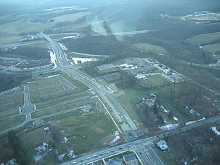
English: Stringtown Road runs from through the center from the bottom to the interchange near the top, where it continues on as MD 121 (Clarksburg Road) to the horizon. MD 121 splits toward the center-right, generally hidden behind trees. These roads interchange with I-270, which runs left to right, toward the top. The left-right roadway at the bottom is MD 355. Clarksburg, MD, USA
|
||||
| Petsa | |||||
| Gigikanan | Kaugalingong trabaho | ||||
| Tagsulat | Andrew Bossi | ||||
| Pagtugot (Paggamit pag-usab niini nga file) |
Own work, share alike, attribution required (Creative Commons CC-BY-SA-2.5) |
I, the copyright holder of this work, hereby publish it under the following license:
This file is licensed under the Creative Commons Attribution-Share Alike 2.5 Generic license.
- Libre ka:
- sa pagsabwag – sa pagkopya, pag-apod-apod ug pagsabwag sa hinimo
- sa pag-remix – sa pag-adap sa binuhat
- Ubos sa mosunod nga mga kondisyon:
- atribusyon – Kinahanglan nimo nga hatagan ang angay nga kredito, maghatag usa ka link sa lisensya, ug ipakita kung adunay mga pagbag-o. Mahimo nimo kini buhaton sa bisan unsang makatarunganon nga paagi, apan dili sa bisan unsang paagi nga nagsugyot nga gi-endorso ka sa licensor o ang imong paggamit.
- share parehas – Kung imong gi-remix, gibag-o, o gibase sa materyal, kinahanglan nimo nga iapod-apod ang imong mga kontribusyon sa ilawom sa parehas o katugma nga lisensya sama sa orihinal.
Kaagi sa payl
I-klik ang petsa/oras aron makit-an ang hulagway sa payl niadtong panahona.
| Petsa/Takna | Thumbnail | Mga dimensyon | Tiggamit | Komento | |
|---|---|---|---|---|---|
| kasamtangan | 23:18, 15 Nobiyembre 2007 | | 2,592 × 1,944 (1.33 MB) | Thisisbossi | {{Information |Description={{en|Stringtown Road runs from through the center from the bottom to the interchange near the top, where it continues on as MD 121 (Clarksburg Road) to the horizon. MD 121 splits toward the center-right, generally hidden behind |
Mga paggamit sa payl
Ang mosunod nga mga panid misumpay niining payl:
Global nga paggamit sa payl
Kining ubang wiki naggamit ning maong payl:
- Paggamit sa ar.wikipedia.org
- Paggamit sa azb.wikipedia.org
- Paggamit sa ca.wikipedia.org
- Paggamit sa en.wikipedia.org
- Paggamit sa es.wikipedia.org
- Paggamit sa eu.wikipedia.org
- Paggamit sa fa.wikipedia.org
- Paggamit sa it.wikipedia.org
- Paggamit sa ky.wikipedia.org
- Paggamit sa lld.wikipedia.org
- Paggamit sa pl.wikipedia.org
- Paggamit sa pt.wikipedia.org
- Paggamit sa sh.wikipedia.org
- Paggamit sa sr.wikipedia.org
- Paggamit sa tt.wikipedia.org
- Paggamit sa uk.wikipedia.org
- Paggamit sa ur.wikipedia.org
- Paggamit sa uz.wikipedia.org
- Paggamit sa www.wikidata.org
- Paggamit sa zh-min-nan.wikipedia.org
- Paggamit sa zh.wikipedia.org