
Payl:LIRR map.svg

Size of this PNG preview of this SVG file: 512 x 304 ka mga piksel. Uban pang mga resoluyon: 320 x 190 ka mga piksel | 640 x 380 ka mga piksel | 1,024 x 608 ka mga piksel | 1,280 x 760 ka mga piksel | 2,560 x 1,520 ka mga piksel.
Tibuok resolusyon (SVG nga payl, nominally 512 × 304 pixels, size sa payl: 370 KB)
Mubong sugid:
| Deskripsyon |
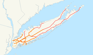
English: This is a map of the rail network currently owned by the Long Island Rail Road. Orange lines are freight-only, and are operated by the New York and Atlantic Railway. Thin black lines have been abandoned. A yellow highlight indicates electrification.
The following GIS data was used:
Deutsch: Karte des Streckennetzes der Long Island Rail Road auf der gleichnamigen Insel.
|
| Petsa | 13 Disyembre 2006 (original upload date) |
| Gigikanan | No machine-readable source provided. Own work assumed (based on copyright claims). |
| Tagsulat | No machine-readable author provided. NE2 assumed (based on copyright claims). |
Pagtugot
| I, the copyright holder of this work, release this work into the public domain. This applies worldwide. In some countries this may not be legally possible; if so: I grant anyone the right to use this work for any purpose, without any conditions, unless such conditions are required by law. |
Kaagi sa payl
I-klik ang petsa/oras aron makit-an ang hulagway sa payl niadtong panahona.
| Petsa/Takna | Thumbnail | Mga dimensyon | Tiggamit | Komento | |
|---|---|---|---|---|---|
| kasamtangan | 22:55, 9 Abril 2017 | | 512 × 304 (370 KB) | Train2104 | Lower Montauk freight only |
| 05:11, 23 Enero 2007 |  | 1,152 × 684 (583 KB) | NE2 | Changed the orange. | |
| 05:05, 23 Enero 2007 |  | 1,152 × 684 (583 KB) | NE2 | Made the black grayer. | |
| 05:03, 23 Enero 2007 |  | 1,152 × 684 (583 KB) | NE2 | Added a few features. | |
| 10:34, 13 Disyembre 2006 |  | 1,152 × 684 (517 KB) | NE2 | This is a map of the rail network currentl[y owned by the Long Island Rail Road. Orange lines are freight-only, and are operated by the New York and Atlantic Railway. The following GIS data was used: *[http://www.bts.gov/publications/north_american_trans |
Mga paggamit sa payl
Ang mosunod nga mga panid misumpay niining payl:
Global nga paggamit sa payl
Kining ubang wiki naggamit ning maong payl:
- Paggamit sa da.wikipedia.org
- Paggamit sa de.wikipedia.org
- Paggamit sa en.wikipedia.org
- Paggamit sa es.wikipedia.org
- Paggamit sa et.wikipedia.org
- Paggamit sa fr.wikipedia.org
- Paggamit sa he.wikivoyage.org
- Paggamit sa id.wikipedia.org
- Paggamit sa it.wikipedia.org
- Paggamit sa ja.wikipedia.org
- Paggamit sa ko.wikipedia.org
- Paggamit sa nl.wikipedia.org
- Paggamit sa no.wikipedia.org
- Paggamit sa oc.wikipedia.org
- Paggamit sa pl.wikipedia.org
- Paggamit sa pt.wikipedia.org
- Paggamit sa ru.wikipedia.org
- Paggamit sa simple.wikipedia.org
- Paggamit sa sv.wikipedia.org
- Paggamit sa www.wikidata.org
- Paggamit sa zh.wikipedia.org