
Payl:Map sagegrouse range2000.JPG
Walay mas taas nga resolusyon.
Map_sagegrouse_range2000.JPG (720 × 540 pixels, size sa payl: 62 KB, MIME type: image/jpeg)
Mubong sugid:
| Deskripsyon |
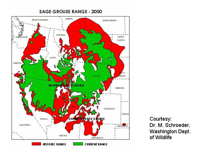
English: Range map of the Greater Sage Grouse (Centrocercus urophasianus) — historical (red) and present day (green) in western North America.
|
| Gigikanan | http://www.fws.gov/mountain-prairie/species/birds/sagegrouse/map_sagegrouse_range2000.JPG |
| Tagsulat | M. Schroeder |
Pagtugot
This image or recording is the work of a U.S. Fish and Wildlife Service employee, taken or made as part of that person's official duties. As a work of the U.S. federal government, the image is in the public domain. For more information, see the Fish and Wildlife Service copyright policy.
|
 |
Kaagi sa payl
I-klik ang petsa/oras aron makit-an ang hulagway sa payl niadtong panahona.
| Petsa/Takna | Thumbnail | Mga dimensyon | Tiggamit | Komento | |
|---|---|---|---|---|---|
| kasamtangan | 13:26, 10 Enero 2009 | | 720 × 540 (62 KB) | Whhalbert | {{Information |Description={{en|1=Range of Greater Sage Grouse (Centrocercus urophasianus), historical and present (2000). The U.S. Fish and Wildlife Service}} |Source=http://www.fws.gov/mountain-prairie/species/birds/sagegrouse/map_sagegrouse_range2000.J |
Mga paggamit sa payl
Ang mosunod nga mga panid misumpay niining payl:
Global nga paggamit sa payl
Kining ubang wiki naggamit ning maong payl:
- Paggamit sa de.wikipedia.org
- Paggamit sa en.wiktionary.org
- Paggamit sa ru.wikipedia.org
- Paggamit sa sv.wikipedia.org
- Paggamit sa vi.wikipedia.org
- Paggamit sa zh.wikipedia.org