
Payl:Mapa Rhinella atacamensis.svg

Size of this PNG preview of this SVG file: 270 x 600 ka mga piksel. Uban pang mga resoluyon: 108 x 240 ka mga piksel | 216 x 480 ka mga piksel | 345 x 768 ka mga piksel | 461 x 1,024 ka mga piksel | 921 x 2,048 ka mga piksel | 288 x 640 ka mga piksel.
Tibuok resolusyon (SVG nga payl, nominally 288 × 640 pixels, size sa payl: 996 KB)
| Deskripsyon |
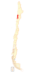
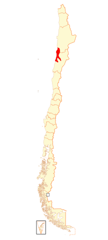
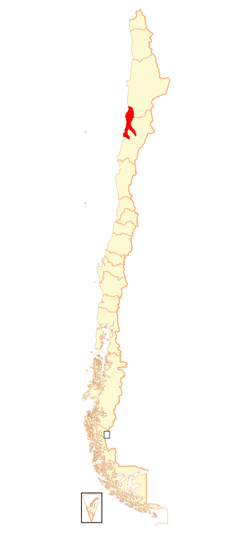
Español: Mapa de Rhinella atacamensis |
| Petsa | (UTC) |
| Gigikanan | |
| Tagsulat |
|
| This is a retouched picture, which means that it has been digitally altered from its original version. Modifications: agrego zona de distribución. The original can be viewed here: Mapa Regiones de Chile.svg:
|

This file is licensed under the Creative Commons Attribution-Share Alike 3.0 Unported license.
Attribution: IUCN Red List of Threatened Species, species assessors and the authors of the spatial data.
- Libre ka:
- sa pagsabwag – sa pagkopya, pag-apod-apod ug pagsabwag sa hinimo
- sa pag-remix – sa pag-adap sa binuhat
- Ubos sa mosunod nga mga kondisyon:
- atribusyon – Kinahanglan nimo nga hatagan ang angay nga kredito, maghatag usa ka link sa lisensya, ug ipakita kung adunay mga pagbag-o. Mahimo nimo kini buhaton sa bisan unsang makatarunganon nga paagi, apan dili sa bisan unsang paagi nga nagsugyot nga gi-endorso ka sa licensor o ang imong paggamit.
- share parehas – Kung imong gi-remix, gibag-o, o gibase sa materyal, kinahanglan nimo nga iapod-apod ang imong mga kontribusyon sa ilawom sa parehas o katugma nga lisensya sama sa orihinal.
Original upload log
This image is a derivative work of the following images:
- File:Mapa_Regiones_de_Chile.svg licensed with Cc-by-sa-3.0,2.5,2.0,1.0, GFDL
- 2009-01-16T20:50:58Z Carlos yo 270x600 (1039852 Bytes) {{Information |Description={{es|1=Mapa de Chile, dividido en regiones.}} |Source=trabajo propio (own work), basado en [[:Image:Mapa Institutos Teletón.svg]] |Author=[[User:Carlos yo|Carlos yo]] |Date=2009-16-1 |Permission= |
Uploaded with derivativeFX
Kaagi sa payl
I-klik ang petsa/oras aron makit-an ang hulagway sa payl niadtong panahona.
| Petsa/Takna | Thumbnail | Mga dimensyon | Tiggamit | Komento | |
|---|---|---|---|---|---|
| kasamtangan | 20:41, 18 Agosto 2018 | | 288 × 640 (996 KB) | Janitoalevic | Ñuble |
| 14:55, 4 Marso 2009 |  | 270 × 600 (1,018 KB) | Ignacio Rodríguez | {{Information |Description={{es|1=Mapa de Rhinella atacamensis}} |Source=*File:Mapa_Regiones_de_Chile.svg |Date=2009-03-04 14:54 (UTC) |Author=*File:Mapa_Regiones_de_Chile.svg: Carlos yo *derivative work: ~~~ |Permission=see |
Mga paggamit sa payl
Ang mosunod nga mga panid misumpay niining payl:
Global nga paggamit sa payl
Kining ubang wiki naggamit ning maong payl:
- Paggamit sa es.wikipedia.org
- Paggamit sa fr.wikipedia.org
- Paggamit sa vi.wikipedia.org