
Payl:Mount mantalingahan palawan.jpg
Walay mas taas nga resolusyon.
Mount_mantalingahan_palawan.jpg (640 × 427 pixels, size sa payl: 302 KB, MIME type: image/jpeg)
Mubong sugid:
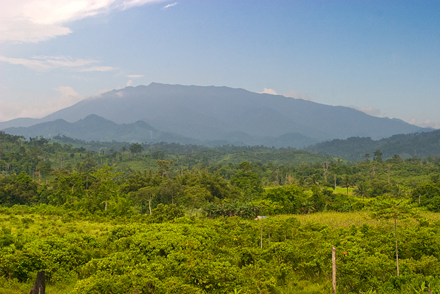
| Deskripsyon | Mount Mantalingahan, an ultramafic peak of 2085 m, photographed from the barangay of Ransang, Rizal municipality, Philippines. The summit ridge is two to three days distant on foot, and one and a half days on the downward return journey (Alastair Robinson, July 2007). | ||
| Petsa | 24 Nobiyembre 2007 (original upload date) | ||
| Gigikanan | Transfered from en.wikipedia | ||
| Tagsulat | Original uploader was Alastair Robinson at en.wikipedia | ||
| Pagtugot (Paggamit pag-usab niini nga file) |
|
Pagtugot
Alastair Robinson at en.wikipedia, the copyright holder of this work, hereby publishes it under the following license:
This file is licensed under the Creative Commons Attribution 3.0 Unported license.
Attribution: Alastair Robinson at en.wikipedia
- Libre ka:
- sa pagsabwag – sa pagkopya, pag-apod-apod ug pagsabwag sa hinimo
- sa pag-remix – sa pag-adap sa binuhat
- Ubos sa mosunod nga mga kondisyon:
- atribusyon – Kinahanglan nimo nga hatagan ang angay nga kredito, maghatag usa ka link sa lisensya, ug ipakita kung adunay mga pagbag-o. Mahimo nimo kini buhaton sa bisan unsang makatarunganon nga paagi, apan dili sa bisan unsang paagi nga nagsugyot nga gi-endorso ka sa licensor o ang imong paggamit.
Original upload log
The original description page is/was here. All following user names refer to en.wikipedia.
- 2007-11-24 09:52 Alastair Robinson 640×427 (302 KB) Mount Mantalingahan, an [[ultramafic]] peak of 2085 [[metre|m]], photographed from the township of Ransang, [[Rizal, Palawan|Rizal Province]], [[Philippines]]. The summit ridge is two to three days distant on foot, and one and a half days on the downward return journey (Alastair Robinson, July 2007).
Kaagi sa payl
I-klik ang petsa/oras aron makit-an ang hulagway sa payl niadtong panahona.
| Petsa/Takna | Thumbnail | Mga dimensyon | Tiggamit | Komento | |
|---|---|---|---|---|---|
| kasamtangan | 15:49, 6 Hunyo 2008 | | 640 × 427 (302 KB) | Ch.Andrew | {{Information |Description= Mount Mantalingahan, an ultramafic peak of 2085 m, photographed from the township of Ransang, Rizal Province, Philippines. The summit ridge is two to three days distant on foot, and one and |
Mga paggamit sa payl
Ang mosunod nga 2 panid misumpay niining payl:
Global nga paggamit sa payl
Kining ubang wiki naggamit ning maong payl:
- Paggamit sa af.wikipedia.org
- Paggamit sa ar.wikipedia.org
- Paggamit sa bcl.wikipedia.org
- Paggamit sa cbk-zam.wikipedia.org
- Paggamit sa de.wikipedia.org
- Paggamit sa en.wikipedia.org
- Paggamit sa es.wikipedia.org
- Paggamit sa fa.wikipedia.org
- Paggamit sa fr.wikipedia.org
- Paggamit sa hu.wikipedia.org
- Paggamit sa ilo.wikipedia.org
- Paggamit sa it.wikipedia.org
- Paggamit sa ka.wikipedia.org
- Paggamit sa lld.wikipedia.org
- Paggamit sa ms.wikipedia.org
- Paggamit sa nl.wikipedia.org
- Paggamit sa no.wikipedia.org
- Paggamit sa pag.wikipedia.org
- Paggamit sa pam.wikipedia.org
- Paggamit sa pt.wikipedia.org
- Paggamit sa ro.wikipedia.org
- Paggamit sa ru.wikipedia.org
- Paggamit sa sv.wikipedia.org
- Paggamit sa th.wikipedia.org
- Paggamit sa tl.wikipedia.org
View more global usage of this file.