Payl:North America second level political division 2.svg

Page contents not supported in other languages.
Gikan sa Wikipedia, ang gawasnong ensiklopedya

Tibuok resolusyon(SVG nga payl, nominally 512 × 596 pixels, size sa payl: 132 KB)

Kining maong payl gikan sa Wikimedia Commons ug mahimong gigamit sa ubang proyekto. Ang deskripsyon niini didto gipakita sa ubos.

Mubong sugid:

Deskripsyon
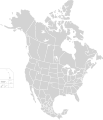
English: Map of North America and its second-level political divisions. Canadian provinces, US and Mexican states. Canada, Mexico, United States.

Non-contiguous parts of a states/provinces are "grouped" together with the main area of the state/provinces, so any state/provinces can be coloured in completion with one click anywhere on the state/provinces's area.

Also, all states/provinces have a "id" attached to them, making them easy to find. Select "find" and then enter in the state/provinces's ISO 3166-2 code in the "id" field to find it. The codes can be found here (Canada), here (USA) and here (Mexico).
Petsa
Gigikanan

Canada and US map: BlankMap-USA-states-Canada-provinces, HI closer.svg by Lokal_Profil.
Mexico map: Mexico template.svg by Mario Fuente Cid
Combined by Alex Covarrubias.

 
The SVG code is valid.
 
This vector image was created with Inkscape, and then manually edited
.
 
W3C-validity not checked.
Tagsulat Alex Covarrubias
Pagtugot
(Paggamit pag-usab niini nga file)
w:en:Creative Commons
atribusyon share parehas
This file is licensed under the Creative Commons Attribution-Share Alike 2.5 Generic license.
Libre ka:
  • sa pagsabwag – sa pagkopya, pag-apod-apod ug pagsabwag sa hinimo
  • sa pag-remix – sa pag-adap sa binuhat
Ubos sa mosunod nga mga kondisyon:
  • atribusyon – Kinahanglan nimo nga hatagan ang angay nga kredito, maghatag usa ka link sa lisensya, ug ipakita kung adunay mga pagbag-o. Mahimo nimo kini buhaton sa bisan unsang makatarunganon nga paagi, apan dili sa bisan unsang paagi nga nagsugyot nga gi-endorso ka sa licensor o ang imong paggamit.
  • share parehas – Kung imong gi-remix, gibag-o, o gibase sa materyal, kinahanglan nimo nga iapod-apod ang imong mga kontribusyon sa ilawom sa parehas o katugma nga lisensya sama sa orihinal.
Other versions

Derivative works of this file:

Captions

Add a one-line explanation of what this file represents

Items portrayed in this file

depicts English

copyrighted English

7 Oktubre 2007

Kaagi sa payl

I-klik ang petsa/oras aron makit-an ang hulagway sa payl niadtong panahona.

Petsa/TaknaThumbnailMga dimensyonTiggamitKomento
kasamtangan01:51, 23 Nobiyembre 2020Thumbnail sa bersyon sa 01:51, 23 Nobiyembre 2020512 × 596 (132 KB)Ponderosapine210Added the prominent islands of Manitoulin (Ontario) and Isle Royale (Michigan) to the Great Lakes.
23:07, 1 Hunyo 2019Thumbnail sa bersyon sa 23:07, 1 Hunyo 2019512 × 596 (130 KB)Fluffy89502added territories, made DC visible, adjusted mexican borders
12:23, 4 Abril 2014Thumbnail sa bersyon sa 12:23, 4 Abril 20141,712 × 1,992 (270 KB)Lommesmade the borders between the mexican subdivisions the same size as their canadian / us counterparts.
23:23, 8 Disyembre 2007Thumbnail sa bersyon sa 23:23, 8 Disyembre 20071,712 × 1,992 (327 KB)Lokal ProfilCode cleanup
07:55, 7 Oktubre 2007Thumbnail sa bersyon sa 07:55, 7 Oktubre 20071,712 × 1,992 (342 KB)AlexCovarrubias== Summary == {{Information |Description=Map of North America and its second-level political divisions. Canadian provinces, US and Mexican states. Canada, Mexico, United States. |Source=Canada and US map by Alan Rockefeller. Mexico map by Alex Covarrubias

There are no pages that use this file.

Global nga paggamit sa payl

Metadata