Jump to content

Payl:Taal Volcano-Pansipit River satellite image.gif

Page contents not supported in other languages.
Gikan sa Wikipedia, ang gawasnong ensiklopedya

Taal_Volcano-Pansipit_River_satellite_image.gif(252 × 252 pixels, size sa payl: 54 KB, MIME type: image/gif)

Kining maong payl gikan sa Wikimedia Commons ug mahimong gigamit sa ubang proyekto. Ang deskripsyon niini didto gipakita sa ubos.

Deskripsyon A cropped version of
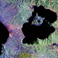
English: Lake Taal and Taal Volcano radar satellite image. From [1].
Emphasis on the Pansipit River-Taal Lake system.
Petsa (UTC)
Gigikanan
Tagsulat


This is a retouched picture, which means that it has been digitally altered from its original version. Modifications: Cropped original photograph. The original can be viewed here: Taal Volcano satellite image.gif. Modifications made by Shrumster.


Public domain This file is in the public domain in the United States because it was solely created by NASA. NASA copyright policy states that "NASA material is not protected by copyright unless noted". (See Template:PD-USGov, NASA copyright policy page or JPL Image Use Policy.)
Warnings:

Original upload log

This image is a derivative work of the following images:

  • Image:Taal_Volcano_satellite_image.gif licensed with PD-USGov-NASA, PD-USGov-NASA/copyright
    • 2008-01-10T19:07:55Z Rémih 450x472 (218708 Bytes) {{Information |Description={{en|Lake Taal and Taal Volcano radar satellite image. From [http://www.jpl.nasa.gov/radar/sircxsar/taal.html].}} |Source=Transferred from [http://en.wikipedia.org en.wikipedia] |Date=2005-03-08 (f

Uploaded with derivativeFX

Captions

Add a one-line explanation of what this file represents

Items portrayed in this file

depicts English

9 Disyembre 2008

Kaagi sa payl

I-klik ang petsa/oras aron makit-an ang hulagway sa payl niadtong panahona.

Petsa/TaknaThumbnailMga dimensyonTiggamitKomento
kasamtangan16:09, 9 Disyembre 2008Thumbnail sa bersyon sa 16:09, 9 Disyembre 2008252 × 252 (54 KB)Shrumster{{Information |Description=A cropped version of {{en|Lake Taal and Taal Volcano radar satellite image. From [http://www.jpl.nasa.gov/radar/sircxsar/taal.html].}} Emphasis on the Pansipit River-Taal Lake system. |Source=*[[:Image:Taal_Volcano_satellite_ima

Ang mosunod nga mga panid misumpay niining payl:

Global nga paggamit sa payl

Kining ubang wiki naggamit ning maong payl: