
Payl:Zanthoxylum clava map.png
Walay mas taas nga resolusyon.
Zanthoxylum_clava_map.png (690 × 571 pixels, size sa payl: 99 KB, MIME type: image/png)

|
This biogeographical map image could be re-created using vector graphics as an SVG file. This has several advantages; see Commons:Media for cleanup for more information. If an SVG form of this image is available, please upload it and afterwards replace this template with
{{vector version available|new image name}}.
It is recommended to name the SVG file “Zanthoxylum clava map.svg”—then the template Vector version available (or Vva) does not need the new image name parameter. |
Mubong sugid:
| Deskripsyon |
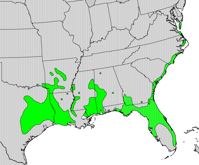
English: Range distribution map of Zanthoxylum clava — syn: Zanthoxylum clava-herculis. |
| Petsa | |
| Gigikanan | Digital representation of "Atlas of United States Trees" by Elbert L. Little, Jr. [1] |
| Tagsulat | U.S. Geological Survey |
Pagtugot
This image is in the public domain in the United States because it only contains materials that originally came from the United States Geological Survey, an agency of the United States Department of the Interior. For more information, see the official USGS copyright policy.
|
Original upload log
Transferred from en.wikipedia to Commons by Fredlyfish4 using CommonsHelper.
The original description page was here. All following user names refer to en.wikipedia.
- 2010-05-21 17:00 Masebrock 690×571× (101712 bytes) {{Information |Description=Range map of Zanthoxylum clava |Source=Digital representation of "Atlas of United States Trees" by Elbert L. Little, Jr. [http://esp.cr.usgs.gov/data/atlas/little/] |Date=1999 |Author=U.S. Geological Survey |Permission={{PD-USGo
Kaagi sa payl
I-klik ang petsa/oras aron makit-an ang hulagway sa payl niadtong panahona.
| Petsa/Takna | Thumbnail | Mga dimensyon | Tiggamit | Komento | |
|---|---|---|---|---|---|
| kasamtangan | 15:08, 27 Oktubre 2012 | | 690 × 571 (99 KB) | File Upload Bot (Magnus Manske) | Transfered from en.wikipedia by User:Fredlyfish4 using CommonsHelper |
Mga paggamit sa payl
Ang mosunod nga mga panid misumpay niining payl:
Global nga paggamit sa payl
Kining ubang wiki naggamit ning maong payl:
- Paggamit sa ast.wikipedia.org
- Paggamit sa en.wikipedia.org
- Paggamit sa sv.wikipedia.org
- Paggamit sa vi.wikipedia.org
- Paggamit sa www.wikidata.org