
Payl:Akiaki Island - Map.jpg

Gidak-on ning maong paunang tan-aw: 800 x 582 ka mga piksel. Uban pang mga resoluyon: 320 x 233 ka mga piksel | 640 x 466 ka mga piksel | 1,024 x 745 ka mga piksel | 1,240 x 902 ka mga piksel.
Tibuok resolusyon (1,240 × 902 pixels, size sa payl: 111 KB, MIME type: image/jpeg)

|
This map image could be re-created using vector graphics as an SVG file. This has several advantages; see Commons:Media for cleanup for more information. If an SVG form of this image is available, please upload it and afterwards replace this template with
{{vector version available|new image name}}.
It is recommended to name the SVG file “Akiaki Island - Map.svg”—then the template Vector version available (or Vva) does not need the new image name parameter. |


Mubong sugid:
| Deskripsyon |
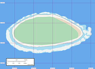
English: Map of Akiaki Island, Tuamotu Archipelago, French Polynesia.
Reef awash
Reef shallow
Land sand
Vegetation forest
Vegetation arid |
| Petsa | |
| Gigikanan | Akiaki Island - Map |
| Tagsulat | Mr Minton from San Diego, US |
Pagtugot
This file is licensed under the Creative Commons Attribution 2.0 Generic license.
- Libre ka:
- sa pagsabwag – sa pagkopya, pag-apod-apod ug pagsabwag sa hinimo
- sa pag-remix – sa pag-adap sa binuhat
- Ubos sa mosunod nga mga kondisyon:
- atribusyon – Kinahanglan nimo nga hatagan ang angay nga kredito, maghatag usa ka link sa lisensya, ug ipakita kung adunay mga pagbag-o. Mahimo nimo kini buhaton sa bisan unsang makatarunganon nga paagi, apan dili sa bisan unsang paagi nga nagsugyot nga gi-endorso ka sa licensor o ang imong paggamit.
| This image, originally posted to Flickr, was reviewed on 9 June 2008 by the administrator or reviewer Jonny-mt, who confirmed that it was available on Flickr under the stated license on that date. |
Kaagi sa payl
I-klik ang petsa/oras aron makit-an ang hulagway sa payl niadtong panahona.
| Petsa/Takna | Thumbnail | Mga dimensyon | Tiggamit | Komento | |
|---|---|---|---|---|---|
| kasamtangan | 08:45, 9 Hunyo 2008 | | 1,240 × 902 (111 KB) | Vriullop | {{Information |Description= {{en|Map of Akiaki, Tuamotu Archipelago, French Polynesia. {{legend|#edf3f3|Reef awash}} {{legend|#a9dcef|Reef shallow}} {{legend|#f7f4ef|Land sand}} {{legend|#aedab6|Vegetation forest}} {{legend|#e9dac5|Vegetation arid}}}} |So |
Mga paggamit sa payl
There are no pages that use this file.
Global nga paggamit sa payl
Kining ubang wiki naggamit ning maong payl:
- Paggamit sa az.wikipedia.org
- Paggamit sa ca.wikipedia.org
- Paggamit sa de.wikipedia.org
- Paggamit sa en.wikipedia.org
- Paggamit sa es.wikipedia.org
- Paggamit sa fi.wikipedia.org
- Paggamit sa fr.wikipedia.org
- Paggamit sa gl.wikipedia.org
- Paggamit sa it.wikipedia.org
- Paggamit sa nl.wikipedia.org
- Paggamit sa pt.wikipedia.org
- Paggamit sa ru.wikipedia.org
- Paggamit sa sk.wikipedia.org
- Paggamit sa sw.wikipedia.org
- Paggamit sa ty.wikipedia.org
- Paggamit sa www.wikidata.org
- Paggamit sa zh.wikipedia.org