
Payl:Bad Hindelang panorama view from south.jpg

Tibuok resolusyon (10,000 × 2,500 pixels, size sa payl: 11.27 MB, MIME type: image/jpeg)
|

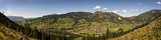
This image was selected as picture of the day on Wikimedia Commons for 25 June 2009. It was captioned as follows: English: Panoramic view of the Ostrachtal near Bad Hindelang on a sunny summer day. Other languages:
Català: Vista panoràmica de la vall d'Ostrach (Ostrachtal), prop de Bad Hindelang a Baviera (Alemanya). Čeština: Panoramatický výhled na Ostrachtal nedaleko bavorského městečka Bad Hindelang Dansk: Panorama over Ostrachtal nær Bad Hindelang på en solrig sommerdag. English: Panoramic view of the Ostrachtal near Bad Hindelang on a sunny summer day. Español: Vista panorámica del valle de Ostrach (Ostrachtal) cerca de Bad Hindelang en Baviera (Alemania) en un soleado día de verano. Esperanto: Panoramo de la Ostrach-valo kaj de Bad Hindelang dum suna somera tago Français : Vue panoramique de l'Ostrachtal près de Hindelang (Allemagne) Malti: Dehra panoramika tal-Ostrachtal qrib Bad Hindelang f'ġurnata sajfija. Nederlands: Panorama over het Beierse Ostrachtal nabij de plaats Bad Hindelang op een zonnige zomerdag. Polski: Panorama Ostrachtal w pobliżu Bad Hindelang, Bawaria, południowe Niemcy, w słoneczny letni dzień. Slovenščina: Panoramski pogled na bavarski Ostrachtal blizu Bad Hindelang na sončen dan 日本語: ドイツ・バイエルン州のBad Hindelang近郊 Ostrachtal のパノラマ。 中文: 德国巴特欣德朗附近奥斯特拉赫山谷的夏日美景 中文(繁體): 德國巴特欣德朗附近奧斯特拉赫山谷的夏日美景 |
Mubong sugid:
| Deskripsyon |
Deutsch: Panoramaansicht des Ostrachtals in der Nähe von Bad Hindelang an einem sonnigen Sommertag. Das Panorama wurde mit einer zylindrischen Projektion erzeugt. Das endgültige Bild hat einen horizontalen Bildwinkel von ca. 180°. Es wurde aus 26 Einzelaufnahmen zusammen gesetzt, die in zwei Reihen aufgenommen wurden.
English: Panoramic view of the Ostrachtal near Bad Hindelang on a sunny summer day. View from the south of the valley. The panoramic image was created by using cylindrical projection. The final picture covers a horizontal field of view of approx. 180°. It was stitched from 26 single images taken in two rows.
Français : Vue panoramique à 180 degrés montrant la vallée de l'Ostrach, près de Bad Hindelang, depuis le sud, par une journée ensoleillée d'été. Image obtenue en assemblant 2 rangs de 13 clichés selon une projection cylindrique. |
| Petsa | |
| Gigikanan | own work (JMatern_070815_7111-7137_WC.jpg) |
| Tagsulat | Jürgen Matern |
| Pagtugot (Paggamit pag-usab niini nga file) |
Jürgen Matern released it under CC-BY-SA |
| Camera location | | View this and other nearby images on: OpenStreetMap |
|---|
Deutsch: Dieses Werk wurde von Jürgen Matern erstellt.
Sie können diese Aufnahme weiterverwenden, so lange Sie mich als Urheber nennen. Beispiel: Falls Sie dieses Bild außerhalb des Wikimedia-Projektes benutzen, würde ich mich freuen von Ihnen zu hören. Möglicherweise habe ich weitere Aufnahmen zum gleichen Objekt/ Thema. Falls Sie die Aufnahme in höherer Auflösung wünschen, so können Sie mich ebenfalls kontaktieren.English: This work was created by Jürgen Matern.
You are free to use it for any purpose as long as you credit me properly. Example: If you use this image outside of Wikimedia projects, I would be happy to hear from you. I may also have more pictures about the same subject/ theme. If you would like to have the picture in a higher resolution, you can also contact me. |

|
NOTE: This image is a panorama consisting of multiple frames that were merged or stitched in software. As a result, this image necessarily underwent some form of digital manipulation. These manipulations may include blending, blurring, cloning, and colour and perspective adjustments. As a result of these adjustments, the image content may be slightly different from reality at the points where multiple images were combined. This manipulation is often required due to lens, perspective, and parallax distortions.
|
| This is a retouched picture, which means that it has been digitally altered from its original version. Modifications: English: This image is a panorama which was stitched from 26 images (two rows with 13 pictueres each). Projection is cylindrical. Horizontal field of view is approx. 180°. Deutsch: Dieses Bild ist ein Panorama, welches aus 26 Einzelaufnahmen zusammengesetzt wurde (zwei Reihen mit je 13 Aufnahmen). Die verwendete Projektion ist zylindrisch. Der horizontale Bildwinkel beträgt ca. 180°. .
|
Pagtugot
- Libre ka:
- sa pagsabwag – sa pagkopya, pag-apod-apod ug pagsabwag sa hinimo
- sa pag-remix – sa pag-adap sa binuhat
- Ubos sa mosunod nga mga kondisyon:
- atribusyon – Kinahanglan nimo nga hatagan ang angay nga kredito, maghatag usa ka link sa lisensya, ug ipakita kung adunay mga pagbag-o. Mahimo nimo kini buhaton sa bisan unsang makatarunganon nga paagi, apan dili sa bisan unsang paagi nga nagsugyot nga gi-endorso ka sa licensor o ang imong paggamit.
- share parehas – Kung imong gi-remix, gibag-o, o gibase sa materyal, kinahanglan nimo nga iapod-apod ang imong mga kontribusyon sa ilawom sa parehas o katugma nga lisensya sama sa orihinal.
| Annotations | This image is annotated: View the annotations at Commons |
Kaagi sa payl
I-klik ang petsa/oras aron makit-an ang hulagway sa payl niadtong panahona.
| Petsa/Takna | Thumbnail | Mga dimensyon | Tiggamit | Komento | |
|---|---|---|---|---|---|
| kasamtangan | 21:11, 3 Septiyembre 2007 | 10,000 × 2,500 (11.27 MB) | JürgenMatern | {{Information |Description=Panoramic view of the Ostrachtal near Bad Hindelang on a sunny summer day. View from the south of the valley. |Source=own work (JMatern_070815_7111-7137_WC.jpg) |Date=2007-08-15 |Author=Jürgen Matern |Per |
Mga paggamit sa payl
Ang mosunod nga mga panid misumpay niining payl:
Global nga paggamit sa payl
Kining ubang wiki naggamit ning maong payl:
- Paggamit sa bn.wikipedia.org
- Paggamit sa crh.wikipedia.org
- Paggamit sa cv.wikipedia.org
- Paggamit sa de.wikipedia.org
- Paggamit sa en.wikipedia.org
- Oberallgäu
- Wikipedia:Featured pictures/Places/Panorama
- Bad Hindelang
- Talk:Bad Hindelang
- Wikipedia:Featured pictures thumbs/17
- Wikipedia:Featured picture candidates/File:Bad Hindelang panorama view from south.jpg
- Wikipedia:Featured picture candidates/May-2009
- Wikipedia:Wikipedia Signpost/2009-05-11/Features and admins
- Wikipedia:Picture of the day/June 2010
- Wikipedia:Wikipedia Signpost/2010-06-21/Features and admins
- Template:POTD/2010-06-20
- Portal talk:Bavaria
- Wikipedia:Wikipedia Signpost/2009-05-11/SPV
- Wikipedia:Wikipedia Signpost/Single/2010-06-21
- User talk:High Contrast/Archive 1
- Wikipedia:WikiProject Germany/Featured Content
- Portal:Germany/Recognized content
- Wikipedia:WikiProject Mountains/Recognized content
- Wikipedia:Wikipedia Signpost/Single/2009-05-11
- Paggamit sa es.wikipedia.org
- Paggamit sa fa.wikipedia.org
- Paggamit sa fr.wikipedia.org
- Paggamit sa hr.wikipedia.org
- Paggamit sa hu.wikipedia.org
- Paggamit sa it.wikipedia.org
- Paggamit sa ko.wikipedia.org
- Paggamit sa ku.wikipedia.org
- Paggamit sa lbe.wikipedia.org
- Paggamit sa mg.wikipedia.org
- Paggamit sa mk.wikipedia.org
- Paggamit sa os.wikipedia.org
- Paggamit sa pa.wikipedia.org
- Paggamit sa pl.wikipedia.org
- Paggamit sa pt.wikipedia.org
- Paggamit sa ro.wikipedia.org
- Paggamit sa ru.wikipedia.org
View more global usage of this file.