
Payl:Bahrain Fort 7.jpg

Gidak-on ning maong paunang tan-aw: 800 x 600 ka mga piksel. Uban pang mga resoluyon: 320 x 240 ka mga piksel | 640 x 480 ka mga piksel | 1,024 x 768 ka mga piksel | 1,280 x 960 ka mga piksel | 2,560 x 1,920 ka mga piksel | 3,264 x 2,448 ka mga piksel.
Tibuok resolusyon (3,264 × 2,448 pixels, size sa payl: 3.72 MB, MIME type: image/jpeg)
| Deskripsyon |
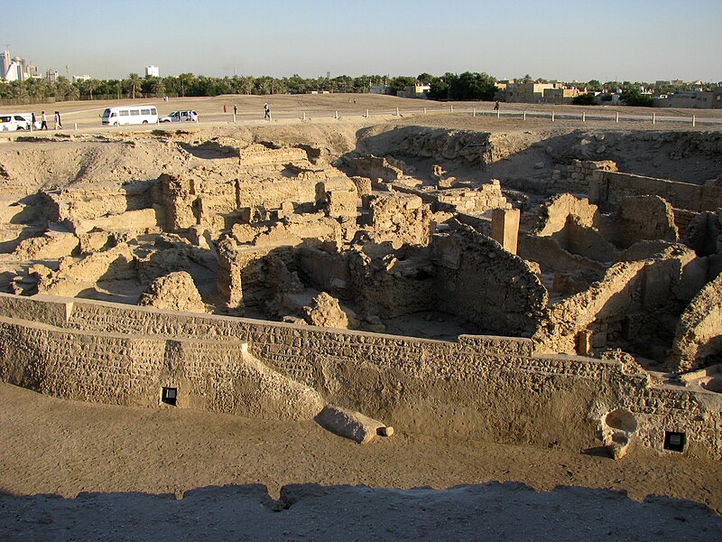
English: The archeological excavations next to the fort are extensive, with some parts dating back to around 2800BC. A visit to the adjacent museum makes it clear why this is listed as a World Heritage site. |
| Petsa | |
| Gigikanan | Excavation next to Bahrain Fort |
| Tagsulat | Peter from Riyadh, Saudi Arabia |
| Camera location | | View this and other nearby images on: OpenStreetMap |
|---|
Pagtugot
This file is licensed under the Creative Commons Attribution 2.0 Generic license.
- Libre ka:
- sa pagsabwag – sa pagkopya, pag-apod-apod ug pagsabwag sa hinimo
- sa pag-remix – sa pag-adap sa binuhat
- Ubos sa mosunod nga mga kondisyon:
- atribusyon – Kinahanglan nimo nga hatagan ang angay nga kredito, maghatag usa ka link sa lisensya, ug ipakita kung adunay mga pagbag-o. Mahimo nimo kini buhaton sa bisan unsang makatarunganon nga paagi, apan dili sa bisan unsang paagi nga nagsugyot nga gi-endorso ka sa licensor o ang imong paggamit.
| This image, originally posted to Flickr, was reviewed on January 28, 2009 by the administrator or reviewer File Upload Bot (Magnus Manske), who confirmed that it was available on Flickr under the stated license on that date. |
Kaagi sa payl
I-klik ang petsa/oras aron makit-an ang hulagway sa payl niadtong panahona.
| Petsa/Takna | Thumbnail | Mga dimensyon | Tiggamit | Komento | |
|---|---|---|---|---|---|
| kasamtangan | 18:21, 28 Enero 2009 | | 3,264 × 2,448 (3.72 MB) | File Upload Bot (Magnus Manske) | {{Information |Description= The archeological excavations next to the fort are extensive, with some parts dating back to around 2800BC. A visit to the adjacent museum makes it clear why this is listed as a World Heritage site. |Source=[http://www.flickr. |
Mga paggamit sa payl
Ang mosunod nga mga panid misumpay niining payl:
Global nga paggamit sa payl
Kining ubang wiki naggamit ning maong payl:
- Paggamit sa ar.wikipedia.org
- Paggamit sa ary.wikipedia.org
- Paggamit sa arz.wikipedia.org
- Paggamit sa be.wikipedia.org
- Paggamit sa bg.wikipedia.org
- Paggamit sa bn.wikipedia.org
- Paggamit sa cs.wikipedia.org
- Paggamit sa de.wikivoyage.org
- Paggamit sa el.wikipedia.org
- Paggamit sa en.wikipedia.org
- Paggamit sa en.wikivoyage.org
- Paggamit sa es.wikipedia.org
- Paggamit sa fa.wikipedia.org
- Paggamit sa fi.wikipedia.org
- Paggamit sa he.wikipedia.org
- Paggamit sa he.wikivoyage.org
- Paggamit sa hi.wikipedia.org
- Paggamit sa hr.wikipedia.org
- Paggamit sa hu.wikipedia.org
- Paggamit sa hy.wikipedia.org
- Paggamit sa id.wikipedia.org
- Paggamit sa it.wikipedia.org
- Paggamit sa ja.wikipedia.org
- Paggamit sa ja.wikivoyage.org
- Paggamit sa ka.wikipedia.org
- Paggamit sa kk.wikipedia.org
- Paggamit sa lt.wikipedia.org
- Paggamit sa mai.wikipedia.org
View more global usage of this file.