
Payl:Barrou Neighbourhood, Étang de Thau, Sète 01.jpg

Gidak-on ning maong paunang tan-aw: 800 x 500 ka mga piksel. Uban pang mga resoluyon: 320 x 200 ka mga piksel | 640 x 400 ka mga piksel | 1,024 x 640 ka mga piksel | 1,280 x 800 ka mga piksel | 2,560 x 1,600 ka mga piksel | 5,453 x 3,408 ka mga piksel.
Tibuok resolusyon (5,453 × 3,408 pixels, size sa payl: 15.6 MB, MIME type: image/jpeg)
Mubong sugid:
| Deskripsyon |
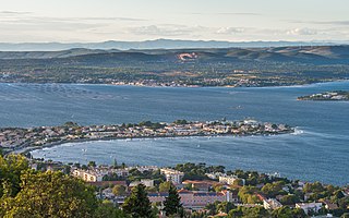
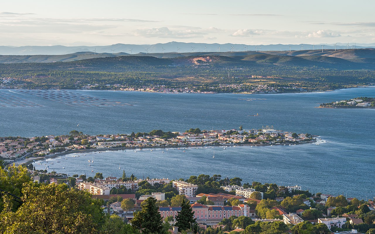
Français : Le quartier du Barrou et l'étang de Thau. Sur la rive opposée la commune de Bouzigues et ses parcs à huitres. Dans le fond, sur les collines le parc éolien de Nord Bassin de Thau. Sète, Hérault, France. English: The Barrou Neighbourhood and the Étang de Thau. On the opposite bank the commune of Bouzigues and its Oyster farms. On the hills in the background, the Nord Bassin de Thau wind farm. Sète, Hérault, France. |
| Petsa | Taken on 10 Septiyembre 2013, 19:14:30 |
| Gigikanan | Kaugalingong trabaho |
| Tagsulat | Christian Ferrer |
| Pagtugot (Paggamit pag-usab niini nga file) |
Christian Ferrer, the copyright holder of this work, hereby publishes it under the following license: This file is licensed under the Creative Commons Attribution-Share Alike 3.0 Unported license. Attribution: Christian Ferrer
|
| Camera location | | View this and other nearby images on: OpenStreetMap |
|---|
|

|
This image has been assessed under the valued image criteria and is considered the most valued image on Commons within the scope: Barrou Neighbourhood, Sète, Hérault, France. General view from southeast in 2013.. You can see its nomination here. |
| Annotations | This image is annotated: View the annotations at Commons |
Kaagi sa payl
I-klik ang petsa/oras aron makit-an ang hulagway sa payl niadtong panahona.
| Petsa/Takna | Thumbnail | Mga dimensyon | Tiggamit | Komento | |
|---|---|---|---|---|---|
| kasamtangan | 11:56, 11 Septiyembre 2013 | | 5,453 × 3,408 (15.6 MB) | Christian Ferrer | User created page with UploadWizard |
Mga paggamit sa payl
Ang mosunod nga mga panid misumpay niining payl:
Global nga paggamit sa payl
Kining ubang wiki naggamit ning maong payl:
- Paggamit sa ca.wikipedia.org
- Paggamit sa de.wikipedia.org
- Paggamit sa en.wikipedia.org
- Paggamit sa es.wikipedia.org
- Paggamit sa eu.wikipedia.org
- Paggamit sa fr.wikipedia.org
- Paggamit sa it.wikipedia.org
- Paggamit sa lv.wikipedia.org
- Paggamit sa mt.wikipedia.org
- Paggamit sa nl.wikipedia.org
- Paggamit sa nn.wikipedia.org
- Paggamit sa oc.wikipedia.org
- Paggamit sa pcd.wikipedia.org
- Paggamit sa simple.wikipedia.org
- Paggamit sa sl.wikipedia.org
- Paggamit sa sv.wikipedia.org
- Paggamit sa vi.wikipedia.org
- Paggamit sa vo.wikipedia.org
- Paggamit sa war.wikipedia.org