
Payl:Blick über die Altstadt von Pirna (Panorama of the historic centre of Pirna) - geograph.org.uk - 7781.jpg
Walay mas taas nga resolusyon.
Blick_über_die_Altstadt_von_Pirna_(Panorama_of_the_historic_centre_of_Pirna)_-_geograph.org.uk_-_7781.jpg (640 × 480 pixels, size sa payl: 89 KB, MIME type: image/jpeg)
Mubong sugid:
| Deskripsyon |
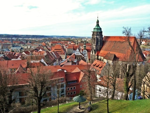
English: Pirna: historic centre.
Deutsch: Pirna: Blick über die historische Altstadt. |
||
| Petsa | |||
| Gigikanan | From geo-en.hlipp.de; transferred by User:oxyman using geograph_org2commons. | ||
| Tagsulat | Norbert Kaiser | ||
| Pagtugot (Paggamit pag-usab niini nga file) |
This file is licensed under the Creative Commons Attribution-Share Alike 2.0 Generic license. Attribution: Norbert Kaiser
|

_-_geograph.org.uk_-_7781.jpg)
| Camera location | | View this and other nearby images on: OpenStreetMap |
|---|
_-_geograph.org.uk_-_7781.jpg¶ms=050.961476_N_0013.945703_E_globe:Earth_type:camera_heading:292.00&language=ceb)
| Annotations | This image is annotated: View the annotations at Commons |
Kaagi sa payl
I-klik ang petsa/oras aron makit-an ang hulagway sa payl niadtong panahona.
| Petsa/Takna | Thumbnail | Mga dimensyon | Tiggamit | Komento | |
|---|---|---|---|---|---|
| kasamtangan | 22:36, 4 Oktubre 2021 | | 640 × 480 (89 KB) | SamsonBVB | Qualität |
| 23:42, 21 Marso 2010 |  | 640 × 480 (98 KB) | File Upload Bot (Magnus Manske) | == Summary == {{Information |Description=Blick �ber die Altstadt von Pirna (Panorama of the historic centre of Pirna) |Source=From [http://geo-en.hlipp.de/photo/7781 geo-en.hlipp.de]; transferred by User:oxyman using [http://toolserver.org/~magnus/g |
Mga paggamit sa payl
Ang mosunod nga 2 panid misumpay niining payl:
Global nga paggamit sa payl
Kining ubang wiki naggamit ning maong payl:
- Paggamit sa an.wikipedia.org
- Paggamit sa ar.wikipedia.org
- Paggamit sa azb.wikipedia.org
- Paggamit sa ba.wikipedia.org
- Paggamit sa be.wikipedia.org
- Paggamit sa ca.wikipedia.org
- Paggamit sa ce.wikipedia.org
- Paggamit sa cs.wikipedia.org
- Paggamit sa de.wikipedia.org
- Paggamit sa de.wikivoyage.org
- Paggamit sa en.wikivoyage.org
- Paggamit sa eo.wikipedia.org
- Paggamit sa es.wikipedia.org
- Paggamit sa et.wikipedia.org
- Paggamit sa fi.wikipedia.org
- Paggamit sa fj.wikipedia.org
- Paggamit sa he.wikipedia.org
- Paggamit sa hu.wikipedia.org
- Paggamit sa id.wikipedia.org
- Paggamit sa ie.wikipedia.org
- Paggamit sa io.wikipedia.org
- Paggamit sa ku.wikipedia.org
- Paggamit sa ky.wikipedia.org
- Paggamit sa lld.wikipedia.org
- Paggamit sa lv.wikipedia.org
- Paggamit sa nl.wikipedia.org
- Paggamit sa nn.wikipedia.org
- Paggamit sa no.wikipedia.org
- Paggamit sa pl.wikipedia.org
- Paggamit sa pl.wikivoyage.org
- Paggamit sa ro.wikipedia.org
- Paggamit sa ru.wikipedia.org
- Paggamit sa sh.wikipedia.org
- Paggamit sa sr.wikipedia.org
- Paggamit sa sv.wikipedia.org
- Paggamit sa tt.wikipedia.org
- Paggamit sa uk.wikipedia.org
- Paggamit sa uz.wikipedia.org
- Paggamit sa vo.wikipedia.org
- Paggamit sa www.wikidata.org
- Paggamit sa zh.wikipedia.org
_-_geograph.org.uk_-_7781.jpg)