
Payl:Carteret Map.jpg

Gidak-on ning maong paunang tan-aw: 800 x 583 ka mga piksel. Uban pang mga resoluyon: 320 x 233 ka mga piksel | 640 x 467 ka mga piksel | 1,024 x 747 ka mga piksel | 1,240 x 904 ka mga piksel.
Tibuok resolusyon (1,240 × 904 pixels, size sa payl: 129 KB, MIME type: image/jpeg)

|
This map image could be re-created using vector graphics as an SVG file. This has several advantages; see Commons:Media for cleanup for more information. If an SVG form of this image is available, please upload it and afterwards replace this template with
{{vector version available|new image name}}.
It is recommended to name the SVG file “Carteret Map.svg”—then the template Vector version available (or Vva) does not need the new image name parameter. |


Mubong sugid:
| Deskripsyon |
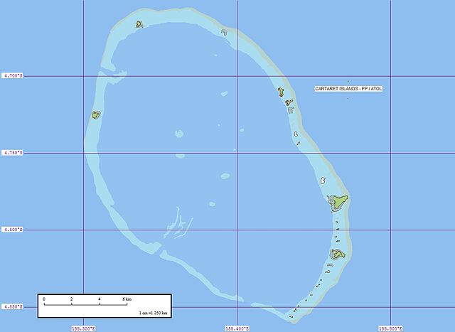
Deutsch: Karte von Kilinailau (auch Carteret-Atoll oder Tulun-Inseln), Papua-Neuguinea
English: Map of Carteret Atoll (also known as Kilinailau or Tulun Islands), Papua New Guinea |
| Petsa | |
| Gigikanan | Flickr |
| Tagsulat | EVS-Islands |
Pagtugot
This file is licensed under the Creative Commons Attribution 2.0 Generic license.
- Libre ka:
- sa pagsabwag – sa pagkopya, pag-apod-apod ug pagsabwag sa hinimo
- sa pag-remix – sa pag-adap sa binuhat
- Ubos sa mosunod nga mga kondisyon:
- atribusyon – Kinahanglan nimo nga hatagan ang angay nga kredito, maghatag usa ka link sa lisensya, ug ipakita kung adunay mga pagbag-o. Mahimo nimo kini buhaton sa bisan unsang makatarunganon nga paagi, apan dili sa bisan unsang paagi nga nagsugyot nga gi-endorso ka sa licensor o ang imong paggamit.
| This image was originally posted to Flickr by EVS-Islands at https://www.flickr.com/photos/60042877@N00/312281441. It was reviewed on 26 Hunyo 2008 by FlickreviewR and was confirmed to be licensed under the terms of the cc-by-2.0. |
Kaagi sa payl
I-klik ang petsa/oras aron makit-an ang hulagway sa payl niadtong panahona.
| Petsa/Takna | Thumbnail | Mga dimensyon | Tiggamit | Komento | |
|---|---|---|---|---|---|
| kasamtangan | 07:32, 29 Mayo 2008 | | 1,240 × 904 (129 KB) | Telim tor | {{Information |Description={{en|1=Map of Carteret Atoll (also known as Tulun Islands), Papua New Guinea}} |Source=[http://www.flickr.com/photos/evsmap/312281441/in/set-72157594402388332/ Flickr] |Author=[http://www.flickr.com/photos/evsmap/ EVS-Islands] | |
Mga paggamit sa payl
Ang mosunod nga mga panid misumpay niining payl:
Global nga paggamit sa payl
Kining ubang wiki naggamit ning maong payl:
- Paggamit sa de.wikipedia.org
- Paggamit sa en.wikipedia.org
- Paggamit sa es.wikipedia.org
- Paggamit sa fr.wikipedia.org
- Paggamit sa fr.wikivoyage.org
- Paggamit sa hu.wikipedia.org
- Paggamit sa ru.wikipedia.org
- Paggamit sa sv.wikipedia.org
- Paggamit sa www.wikidata.org