
Payl:Conneaut Ohio aerial view.jpg

Gidak-on ning maong paunang tan-aw: 800 x 561 ka mga piksel. Uban pang mga resoluyon: 320 x 224 ka mga piksel | 640 x 449 ka mga piksel | 1,024 x 718 ka mga piksel | 1,280 x 898 ka mga piksel | 1,500 x 1,052 ka mga piksel.
Tibuok resolusyon (1,500 × 1,052 pixels, size sa payl: 697 KB, MIME type: image/jpeg)
Mubong sugid:
| Deskripsyon |
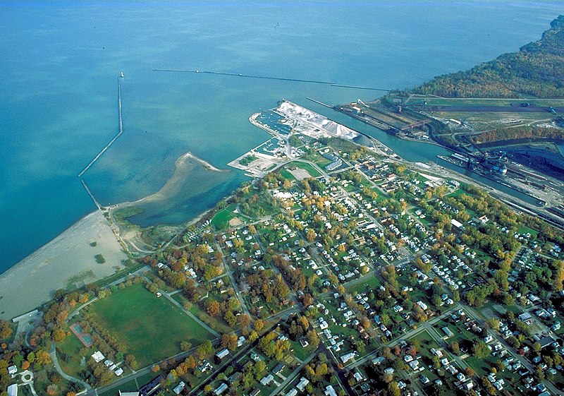
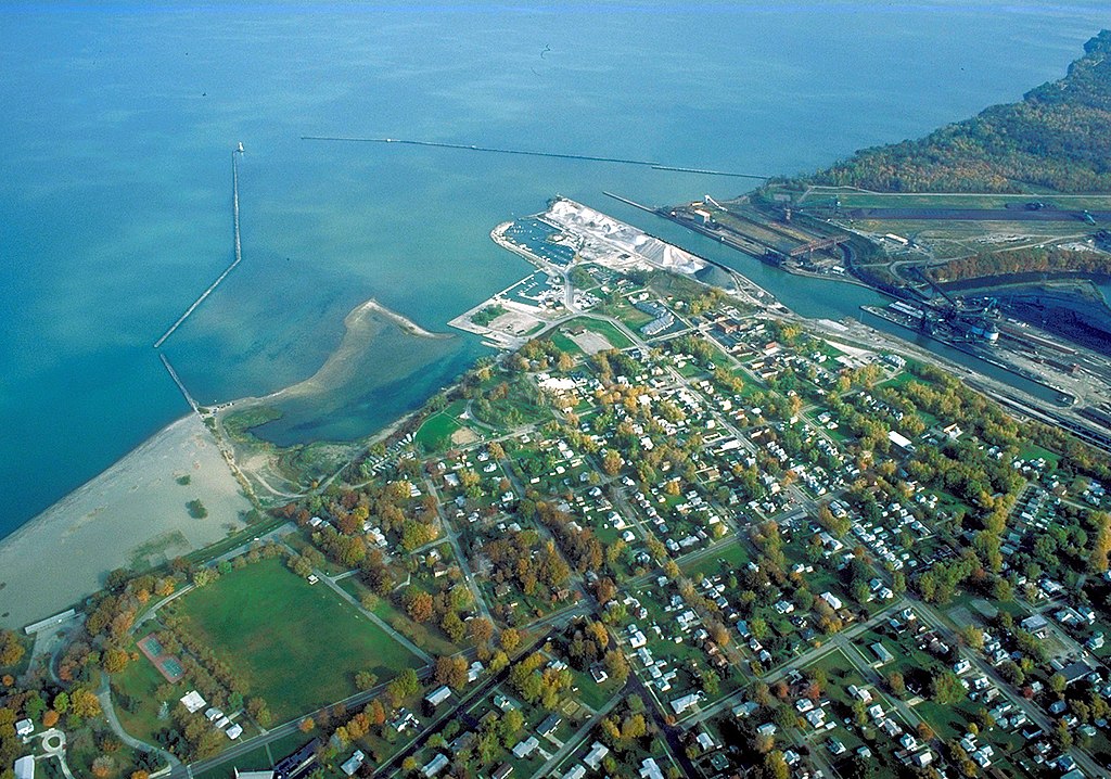
English: Aerial view of the port and harbor at Conneaut, Ohio, USA, on Lake Erie. View is to the northeast over the lake. |
| Petsa | Taken on 28 Oktubre 1992 |
| Gigikanan |
U.S. Army Corps of Engineers Digital Visual Library Image page Image description page Digital Visual Library home page |
| Tagsulat | Ken Winters, U.S. Army Corps of Engineers |
| Location | Conneaut, Ohio, USA |
| Camera location | | View this and other nearby images on: OpenStreetMap |
|---|
Pagtugot
This image or file is a work of a U.S. Army Corps of Engineers soldier or employee, taken or made as part of that person's official duties. As a work of the U.S. federal government, the image is in the public domain.
|
Kaagi sa payl
I-klik ang petsa/oras aron makit-an ang hulagway sa payl niadtong panahona.
| Petsa/Takna | Thumbnail | Mga dimensyon | Tiggamit | Komento | |
|---|---|---|---|---|---|
| kasamtangan | 05:54, 31 Marso 2007 | | 1,500 × 1,052 (697 KB) | DanMS | {{Information | Description = {{en|Aerial view of the port and harbor at Conneaut, Ohio, USA, on Lake Erie. View is to the northeast over the lake.}} | Source = U.S. Army Corps of Engineers Digital Visual Library<br />[http://images.usace.army. |
Mga paggamit sa payl
Ang mosunod nga 2 panid misumpay niining payl:
Global nga paggamit sa payl
Kining ubang wiki naggamit ning maong payl:
- Paggamit sa ar.wikipedia.org
- Paggamit sa arz.wikipedia.org
- Paggamit sa azb.wikipedia.org
- Paggamit sa ca.wikipedia.org
- Paggamit sa ce.wikipedia.org
- Paggamit sa cy.wikipedia.org
- Paggamit sa dag.wikipedia.org
- Paggamit sa de.wikipedia.org
- Paggamit sa en.wikipedia.org
- Paggamit sa en.wikivoyage.org
- Paggamit sa es.wikipedia.org
- Paggamit sa eu.wikipedia.org
- Paggamit sa fa.wikipedia.org
- Paggamit sa fr.wikipedia.org
- Paggamit sa ht.wikipedia.org
- Paggamit sa hu.wikipedia.org
- Paggamit sa it.wikipedia.org
- Paggamit sa ky.wikipedia.org
- Paggamit sa lld.wikipedia.org
- Paggamit sa pl.wikipedia.org
- Paggamit sa pt.wikipedia.org
- Paggamit sa sh.wikipedia.org
- Paggamit sa simple.wikipedia.org
- Paggamit sa sr.wikipedia.org
- Paggamit sa szl.wikipedia.org
- Paggamit sa tr.wikipedia.org
- Paggamit sa tt.wikipedia.org
- Paggamit sa uk.wikipedia.org
- Paggamit sa uz.wikipedia.org
- Paggamit sa vi.wikipedia.org
- Paggamit sa vo.wikipedia.org
- Paggamit sa www.wikidata.org
- Paggamit sa zh-min-nan.wikipedia.org