
Payl:Crags on summit of Mynydd Graig Goch - geograph.org.uk - 196667.jpg
Walay mas taas nga resolusyon.
Crags_on_summit_of_Mynydd_Graig_Goch_-_geograph.org.uk_-_196667.jpg (640 × 480 pixels, size sa payl: 138 KB, MIME type: image/jpeg)
Mubong sugid:
| Deskripsyon |
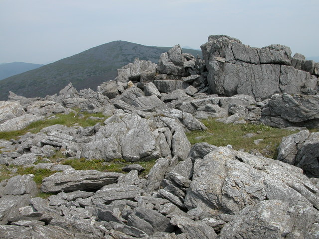
English: Crags on summit of Mynydd Graig Goch. Mynydd Graig Goch is situated at the western end of the Nantlle Ridge, though many walkers do not venture beyond Garnedd-goch which can be seen in the background. The summit of Snowdon is just visible between the rocky crags.
In September 2008, this summit made national news after three walkers surveyed it after suspecting it was really just over 2000 feet and therefore officially classified as a mountain. Their survey has been recognised by Ordnance Survey thus bringing the total of mountains in Wales to 190. Maybe now it has been elevated to mountain status it will attract more walkers to its rocky summit. See: https://www.telegraph.co.uk/news/newstopics/politics/wales/2989936/Wales-acquires-a-new-mountain-but-loses-a-hill.html |
| Petsa | |
| Gigikanan | From geograph.org.uk |
| Tagsulat | Philip Halling |
| Attribution (required by the license) | Philip Halling / Crags on summit of Mynydd Graig Goch / |
| Camera location | | View this and other nearby images on: OpenStreetMap |
|---|
_heading:45.00&language=ceb)
| Object location | | View this and other nearby images on: OpenStreetMap |
|---|
_heading:45.00&language=ceb)
Pagtugot

|
This image was taken from the Geograph project collection. See this photograph's page on the Geograph website for the photographer's contact details. The copyright on this image is owned by Philip Halling and is licensed for reuse under the Creative Commons Attribution-ShareAlike 2.0 license.
|
This file is licensed under the Creative Commons Attribution-Share Alike 2.0 Generic license.
Attribution: Philip Halling
- Libre ka:
- sa pagsabwag – sa pagkopya, pag-apod-apod ug pagsabwag sa hinimo
- sa pag-remix – sa pag-adap sa binuhat
- Ubos sa mosunod nga mga kondisyon:
- atribusyon – Kinahanglan nimo nga hatagan ang angay nga kredito, maghatag usa ka link sa lisensya, ug ipakita kung adunay mga pagbag-o. Mahimo nimo kini buhaton sa bisan unsang makatarunganon nga paagi, apan dili sa bisan unsang paagi nga nagsugyot nga gi-endorso ka sa licensor o ang imong paggamit.
- share parehas – Kung imong gi-remix, gibag-o, o gibase sa materyal, kinahanglan nimo nga iapod-apod ang imong mga kontribusyon sa ilawom sa parehas o katugma nga lisensya sama sa orihinal.
Kaagi sa payl
I-klik ang petsa/oras aron makit-an ang hulagway sa payl niadtong panahona.
| Petsa/Takna | Thumbnail | Mga dimensyon | Tiggamit | Komento | |
|---|---|---|---|---|---|
| kasamtangan | 15:38, 31 Enero 2010 | | 640 × 480 (138 KB) | GeographBot | == {{int:filedesc}} == {{Information |description={{en|1=Crags on summit of Mynydd Graig Goch. Mynydd Graig Goch is situated at the western end of the Nantlle Ridge, though many walkers do not venture beyond Garnedd-goch which can be seen in the backgroun |
Mga paggamit sa payl
Ang mosunod nga mga panid misumpay niining payl:
Global nga paggamit sa payl
Kining ubang wiki naggamit ning maong payl:
- Paggamit sa arz.wikipedia.org
- Paggamit sa cy.wikipedia.org
- Paggamit sa en.wikipedia.org
- Paggamit sa lld.wikipedia.org
- Paggamit sa sv.wikipedia.org
- Paggamit sa www.wikidata.org