
Payl:F 57 Aqueduc Jouy-aux-Arches.JPG

Gidak-on ning maong paunang tan-aw: 800 x 600 ka mga piksel. Uban pang mga resoluyon: 320 x 240 ka mga piksel | 640 x 480 ka mga piksel | 1,024 x 768 ka mga piksel | 1,280 x 960 ka mga piksel | 1,632 x 1,224 ka mga piksel.
Tibuok resolusyon (1,632 × 1,224 pixels, size sa payl: 1.69 MB, MIME type: image/jpeg)
|
This building is classé au titre des monuments historiques de la France. It is indexed in the base Mérimée, a database of architectural heritage maintained by the French Ministry of Culture, under the reference PA00106791
|
Mubong sugid:
| Deskripsyon |
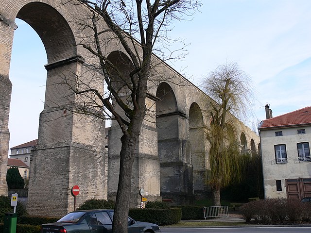
English: Roman aqueduc from Gorze to Metz - outdoor view in Jouy-aux-Arches
Français : Aqueduc romain de Gorze à Metz (Lorraine) - section aérienne traversant le village de Jouy-aux-Arches |
| Petsa | |
| Gigikanan | Kaugalingong trabaho |
| Tagsulat | François BERNARDIN |
| Object location | | View this and other nearby images on: OpenStreetMap |
|---|
Pagtugot
I, the copyright holder of this work, hereby publish it under the following licenses:

|
Gitugot ang pagkopya, pag-apud-apod o/ug pag-usab ning maong dokumento ubos sa mga termino sa GNU Free Documentation License, Version 1.2 o mas bag-ong bersiyon nga gimantala sa Free Software Foundation; nga walay Invariant Sections, walay Front-Cover Texts, ug walay Back-Cover Texts. Ang kopya sa lisensiya gilakip sa bahin nga giulohang GNU Free Documentation License. |
This file is licensed under the Creative Commons Attribution 3.0 Unported license.
- Libre ka:
- sa pagsabwag – sa pagkopya, pag-apod-apod ug pagsabwag sa hinimo
- sa pag-remix – sa pag-adap sa binuhat
- Ubos sa mosunod nga mga kondisyon:
- atribusyon – Kinahanglan nimo nga hatagan ang angay nga kredito, maghatag usa ka link sa lisensya, ug ipakita kung adunay mga pagbag-o. Mahimo nimo kini buhaton sa bisan unsang makatarunganon nga paagi, apan dili sa bisan unsang paagi nga nagsugyot nga gi-endorso ka sa licensor o ang imong paggamit.
You may select the license of your choice.
Kaagi sa payl
I-klik ang petsa/oras aron makit-an ang hulagway sa payl niadtong panahona.
| Petsa/Takna | Thumbnail | Mga dimensyon | Tiggamit | Komento | |
|---|---|---|---|---|---|
| kasamtangan | 21:11, 15 Pebrero 2009 | | 1,632 × 1,224 (1.69 MB) | Freb | {{Information |Description={{en|1=Roman aqueduc from Gorze to Metz - outdoor view in Jouy-aux-Arches}} {{fr|1=Aqueduc romain de Gorze à Metz (Lorraine) - section aérienne traversant le village de Jouy-aux-Arches}} |Source=own work |Author=François BERN |
Mga paggamit sa payl
Ang mosunod nga mga panid misumpay niining payl:
Global nga paggamit sa payl
Kining ubang wiki naggamit ning maong payl:
- Paggamit sa als.wikipedia.org
- Paggamit sa ast.wikipedia.org
- Paggamit sa bo.wikipedia.org
- Paggamit sa ca.wikipedia.org
- Paggamit sa ce.wikipedia.org
- Paggamit sa de.wikipedia.org
- Paggamit sa de.wikivoyage.org
- Paggamit sa diq.wikipedia.org
- Paggamit sa el.wikipedia.org
- Paggamit sa en.wikipedia.org
- Paggamit sa es.wikipedia.org
- Paggamit sa eu.wikipedia.org
- Paggamit sa fr.wikipedia.org
- Paggamit sa hu.wikipedia.org
- Paggamit sa it.wikipedia.org
- Paggamit sa ku.wikipedia.org
- Paggamit sa la.wikipedia.org
- Paggamit sa lld.wikipedia.org
- Paggamit sa ms.wikipedia.org
- Paggamit sa nl.wikipedia.org
- Paggamit sa oc.wikipedia.org
- Paggamit sa pfl.wikipedia.org
- Paggamit sa pl.wikipedia.org
- Paggamit sa pms.wikipedia.org
- Paggamit sa pt.wikipedia.org
- Paggamit sa ru.wikipedia.org
- Paggamit sa sk.wikipedia.org
- Paggamit sa sv.wikipedia.org
- Paggamit sa tt.wikipedia.org
- Paggamit sa uk.wikipedia.org
- Paggamit sa uz.wikipedia.org
- Paggamit sa vec.wikipedia.org
- Paggamit sa www.wikidata.org
- Paggamit sa zh-min-nan.wikipedia.org
- Paggamit sa zh.wikipedia.org