
Payl:Fiddlers Ferry Power Station - geograph.org.uk - 1696162.jpg
Gidak-on ning maong paunang tan-aw: 800 x 480 ka mga piksel. Uban pang mga resoluyon: 320 x 192 ka mga piksel | 1,024 x 615 ka mga piksel.
Tibuok resolusyon (1,024 × 615 pixels, size sa payl: 317 KB, MIME type: image/jpeg)
Mubong sugid:
| Deskripsyon |
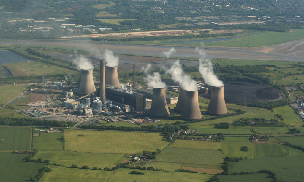
English: Fiddlers Ferry Power Station, 3 km from Bold Heath, St Helens, Great Britain.
Aerial view of Fiddlers Ferry Power Station in the centre we have Fowl Farm the public footpath can be seen winding through the farm and over the fields. The dogs home to the left,Cuerdley village front and the Cuerdley Cross pub to the right we have Fiddlers Ferry Angling Society pond. |
| Petsa | |
| Gigikanan | From geograph.org.uk; transferred by User:Fintan264 using geograph_org2commons. |
| Tagsulat | Alan James |
| Pagtugot (Paggamit pag-usab niini nga file) |
Creative Commons Attribution Share-alike license 2.0 |
| Attribution (required by the license) | Alan James / Fiddlers Ferry Power Station / |
| Camera location | | View this and other nearby images on: OpenStreetMap |
|---|
| Object location | | View this and other nearby images on: OpenStreetMap |
|---|
_region:GB-GBN_heading:157.00&language=ceb)
Pagtugot

|
This image was taken from the Geograph project collection. See this photograph's page on the Geograph website for the photographer's contact details. The copyright on this image is owned by Alan James and is licensed for reuse under the Creative Commons Attribution-ShareAlike 2.0 license.
|
This file is licensed under the Creative Commons Attribution-Share Alike 2.0 Generic license.
Attribution: Alan James
- Libre ka:
- sa pagsabwag – sa pagkopya, pag-apod-apod ug pagsabwag sa hinimo
- sa pag-remix – sa pag-adap sa binuhat
- Ubos sa mosunod nga mga kondisyon:
- atribusyon – Kinahanglan nimo nga hatagan ang angay nga kredito, maghatag usa ka link sa lisensya, ug ipakita kung adunay mga pagbag-o. Mahimo nimo kini buhaton sa bisan unsang makatarunganon nga paagi, apan dili sa bisan unsang paagi nga nagsugyot nga gi-endorso ka sa licensor o ang imong paggamit.
- share parehas – Kung imong gi-remix, gibag-o, o gibase sa materyal, kinahanglan nimo nga iapod-apod ang imong mga kontribusyon sa ilawom sa parehas o katugma nga lisensya sama sa orihinal.
Kaagi sa payl
I-klik ang petsa/oras aron makit-an ang hulagway sa payl niadtong panahona.
| Petsa/Takna | Thumbnail | Mga dimensyon | Tiggamit | Komento | |
|---|---|---|---|---|---|
| kasamtangan | 16:51, 30 Enero 2011 | | 1,024 × 615 (317 KB) | File Upload Bot (Magnus Manske) |
Mga paggamit sa payl
Ang mosunod nga mga panid misumpay niining payl:
Global nga paggamit sa payl
Kining ubang wiki naggamit ning maong payl:
- Paggamit sa en.wikipedia.org
- Paggamit sa fr.wikipedia.org
- Paggamit sa www.wikidata.org