
Payl:Gibraltar map-en-edit2.svg

Size of this PNG preview of this SVG file: 385 x 600 ka mga piksel. Uban pang mga resoluyon: 154 x 240 ka mga piksel | 308 x 480 ka mga piksel | 493 x 768 ka mga piksel | 657 x 1,024 ka mga piksel | 1,314 x 2,048 ka mga piksel | 1,000 x 1,558 ka mga piksel.
Tibuok resolusyon (SVG nga payl, nominally 1,000 × 1,558 pixels, size sa payl: 1.46 MB)
Mubong sugid:
|
This W3C-unspecified vector image was created with Inkscape .
| Camera location | | View this and other nearby images on: OpenStreetMap |
|---|
| Deskripsyon |
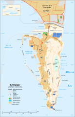
English: Map in English of Gibraltar
Français : Carte en anglais de Gibraltar |
| Petsa | |
| Gigikanan |
English: adapted from: Image:Gibraltar map-en.svg
Français : Création personnelle ;
|
| Tagsulat | Original by Eric Gaba (Sting), label/legend edits by Jeff Dahl |
| Pagtugot (Paggamit pag-usab niini nga file) |
Attribution and Share-Alike required |
| Other versions |
|


|
This SVG file contains embedded text that can be translated into your language, using any capable SVG editor, text editor or the SVG Translate tool. For more information see: About translating SVG files. |
Pagtugot
I, the copyright holder of this work, hereby publish it under the following licenses:

|
Gitugot ang pagkopya, pag-apud-apod o/ug pag-usab ning maong dokumento ubos sa mga termino sa GNU Free Documentation License, Version 1.2 o mas bag-ong bersiyon nga gimantala sa Free Software Foundation; nga walay Invariant Sections, walay Front-Cover Texts, ug walay Back-Cover Texts. Ang kopya sa lisensiya gilakip sa bahin nga giulohang GNU Free Documentation License. |
This file is licensed under the Creative Commons Attribution-Share Alike 4.0 International, 3.0 Unported, 2.5 Generic, 2.0 Generic and 1.0 Generic license.
- Libre ka:
- sa pagsabwag – sa pagkopya, pag-apod-apod ug pagsabwag sa hinimo
- sa pag-remix – sa pag-adap sa binuhat
- Ubos sa mosunod nga mga kondisyon:
- atribusyon – Kinahanglan nimo nga hatagan ang angay nga kredito, maghatag usa ka link sa lisensya, ug ipakita kung adunay mga pagbag-o. Mahimo nimo kini buhaton sa bisan unsang makatarunganon nga paagi, apan dili sa bisan unsang paagi nga nagsugyot nga gi-endorso ka sa licensor o ang imong paggamit.
- share parehas – Kung imong gi-remix, gibag-o, o gibase sa materyal, kinahanglan nimo nga iapod-apod ang imong mga kontribusyon sa ilawom sa parehas o katugma nga lisensya sama sa orihinal.
You may select the license of your choice.
Kaagi sa payl
I-klik ang petsa/oras aron makit-an ang hulagway sa payl niadtong panahona.
| Petsa/Takna | Thumbnail | Mga dimensyon | Tiggamit | Komento | |
|---|---|---|---|---|---|
| kasamtangan | 16:36, 5 Abril 2017 | | 1,000 × 1,558 (1.46 MB) | RaviC | + University, Ferry terminal (& Route), Cathedral |
| 18:52, 11 Disyembre 2007 |  | 1,000 × 1,558 (1.79 MB) | Jeff Dahl | resized 1200 down to 1000px wide, minor label fixes | |
| 17:08, 10 Disyembre 2007 |  | 1,200 × 1,870 (1.78 MB) | Jeff Dahl | {{inkscape}} {{Location|36|08|00|N|5|21|00|W|type:city_scale:50000}} {{Information |Description=Map in English of Gibraltar |Source=adapted from: Image:Gibraltar map-en.svg <br/>Map created using screenshots of [[:en:Google Ea |
Mga paggamit sa payl
Ang mosunod nga 65 panid misumpay niining payl:
- Ailsa Craig
- Ailsa Craig (bato)
- Alameda Gardens
- Blackstrap Bay
- Cable Car Station
- Caledonian Canal
- Caledonian Canal (kanal sa Gyibraltar)
- Camp Bay
- Camp Bay (luuk)
- Cerro de Enmedio
- Cradle of History
- Cross of Sacrifice
- Deadmans Beach
- Douglas's Cave
- Eastern Beach
- Eastern Beach (lapyahan sa Gyibraltar)
- El Peñón
- Elliots Memorial
- Europa Pass
- Europa Point
- Europa Point (punta sa Gyibraltar)
- Gibilterra
- Gibraltar
- Gibraltar (pagklaro)
- Gibraltar Bay
- Gibraltar International Airport
- Gorham's Cave
- Governor's Beach (lapyahan sa Gyibraltar)
- Governor’s Beach
- Great Europa Point
- Great Europa Point (punta sa Gyibraltar)
- Great Siege Tunnels
- Guild's Point
- H.M.S. Rooke
- Hayne's Cave
- La Roca
- Levant Cave
- Little Europa Point
- Martin's Cave
- Mediterranean Steps
- Middle Hill
- Middle Hill (bungtod sa Gyibraltar)
- Moorish Castle
- Mosque of Two Holy Custodians
- North Gorge
- Passage Point
- Punta Europa
- Punta Pasaje
- Roca Blanca
- Rock of Gibraltar
- Rock of Gibraltar (bukid)
- Saint Abb's Head
- Saint Michael's Cave
- Sandy Bay
- Sandy Bay (luuk)
- Sandy Bay North
- Signal Hill
- Signal Hill (bungtod sa Gyibraltar)
- The Lido
- The Rock
- Western Beach
- Western Beach (lapyahan sa Gyibraltar)
- White Rock
- White Rock (bato sa Gyibraltar)
- Plantilya:Location map Gibraltar
Global nga paggamit sa payl
Kining ubang wiki naggamit ning maong payl:
- Paggamit sa af.wikipedia.org
- Paggamit sa ar.wikipedia.org
- Paggamit sa av.wikipedia.org
- Paggamit sa azb.wikipedia.org
- Paggamit sa bg.wikipedia.org
- Paggamit sa bn.wikipedia.org
- Paggamit sa bs.wikipedia.org
- Paggamit sa ckb.wikipedia.org
- Paggamit sa cy.wikipedia.org
- Paggamit sa da.wikipedia.org
- Paggamit sa el.wikipedia.org
- Paggamit sa en.wikipedia.org
- Llanito
- Rock of Gibraltar
- Disputed status of the isthmus between Gibraltar and Spain
- Portal:Maps/Selected picture
- Gibraltar
- Wikipedia:WikiProject Gibraltar
- Portal:United Kingdom/Featured picture
- Wikipedia:Wikipedia Signpost/2007-12-17/Features and admins
- Wikipedia:Featured pictures thumbs/09
- Portal:Gibraltar/Selected picture
- Wikipedia:Featured picture candidates/December-2007
- Wikipedia:Featured picture candidates/Map of Gibraltar
- Portal:Gibraltar/Selected picture/2
- Portal:Maps/Selected picture/31
- User talk:Jeff Dahl/Archive 2
- Wikipedia:Featured pictures/Diagrams, drawings, and maps/Maps
- Template:POTD/2008-09-10
- User talk:Jeff Dahl/Archive 4
- Wikipedia:Picture of the day/September 2008
- Wikipedia:Wikipedia Signpost/2007-12-17/SPV
- Gibraltarian English
- Gibraltar Major Residential Areas
- Template:Did you know nominations/Gibraltar North Mole Lighthouse
- List of lighthouses in Gibraltar
- South Mole, Gibraltar Harbour
- Detached Mole, Gibraltar Harbour
- North Mole, Gibraltar Harbour
- Marina Bay, Gibraltar
- Gibraltar Diamond Jubilee Flotilla
- Rosia Bay
- Gibraltar Port Authority
- Wikipedia:GLAM/GibraltarpediA/Images/Geography
- Gibraltar Nature Reserve
- Wikipedia:Wikipedia Signpost/Single/2007-12-17
- Paggamit sa eo.wikipedia.org
- Paggamit sa eu.wikipedia.org
View more global usage of this file.