
Payl:Harlan Kentucky Aerial view.jpg

Gidak-on ning maong paunang tan-aw: 800 x 533 ka mga piksel. Uban pang mga resoluyon: 320 x 213 ka mga piksel | 640 x 427 ka mga piksel | 1,024 x 683 ka mga piksel | 1,500 x 1,000 ka mga piksel.
Tibuok resolusyon (1,500 × 1,000 pixels, size sa payl: 732 KB, MIME type: image/jpeg)
| Deskripsyon |
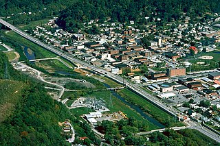
English: Aerial view of Harlan, Kentucky, USA. View is to the northeast. The main highway, U.S. Route 421, runs diagonally across the picture. The U.S. Army Corps of Engineers has constructed levees and a long floodwall along the Martins Fork River to prevent recurrence of the disastrous floods of 1977. |
|||
| Petsa | ||||
| Gigikanan |
U.S. Army Corps of Engineers Digital Visual Library Image page Image description page Digital Visual Library home page |
|||
| Tagsulat | U.S. Army Corps of Engineers, photographer not specified or unknown | |||
| Pagtugot (Paggamit pag-usab niini nga file) |
|
|||
| Location | Harlan, Kentucky, USA |
| Camera location | | View this and other nearby images on: OpenStreetMap |
|---|
Kaagi sa payl
I-klik ang petsa/oras aron makit-an ang hulagway sa payl niadtong panahona.
| Petsa/Takna | Thumbnail | Mga dimensyon | Tiggamit | Komento | |
|---|---|---|---|---|---|
| kasamtangan | 02:22, 25 Marso 2007 | | 1,500 × 1,000 (732 KB) | DanMS | {{Information | Description = {{en|Aerial view of Harlan, Kentucky, USA. View is to the northeast. The main highway, U.S. Route 421, runs diagonally across the picture. The U.S. Army Corps of Engineers has constructed levees and a long floodwall along |
Mga paggamit sa payl
Ang mosunod nga mga panid misumpay niining payl:
Global nga paggamit sa payl
Kining ubang wiki naggamit ning maong payl:
- Paggamit sa ar.wikipedia.org
- Paggamit sa arz.wikipedia.org
- Paggamit sa azb.wikipedia.org
- Paggamit sa ca.wikipedia.org
- Paggamit sa ce.wikipedia.org
- Paggamit sa en.wikipedia.org
- Paggamit sa es.wikipedia.org
- Paggamit sa eu.wikipedia.org
- Paggamit sa fa.wikipedia.org
- Paggamit sa ht.wikipedia.org
- Paggamit sa hu.wikipedia.org
- Paggamit sa id.wikipedia.org
- Paggamit sa io.wikipedia.org
- Paggamit sa it.wikipedia.org
- Paggamit sa ky.wikipedia.org
- Paggamit sa lld.wikipedia.org
- Paggamit sa pl.wikipedia.org
- Paggamit sa pt.wikipedia.org
- Paggamit sa ru.wikipedia.org
- Paggamit sa sh.wikipedia.org
- Paggamit sa simple.wikipedia.org
- Paggamit sa sr.wikipedia.org
- Paggamit sa sv.wikipedia.org
- Paggamit sa tl.wikipedia.org
- Paggamit sa tr.wikipedia.org
- Paggamit sa tt.wikipedia.org
- Paggamit sa uz.wikipedia.org
- Paggamit sa www.wikidata.org
- Paggamit sa zh-min-nan.wikipedia.org