
Payl:Himalayan Horizon From Space.jpg

Gidak-on ning maong paunang tan-aw: 800 x 502 ka mga piksel. Uban pang mga resoluyon: 320 x 201 ka mga piksel | 640 x 402 ka mga piksel | 1,024 x 643 ka mga piksel | 1,530 x 960 ka mga piksel.
Tibuok resolusyon (1,530 × 960 pixels, size sa payl: 291 KB, MIME type: image/jpeg)
Mubong sugid:
| Deskripsyon |
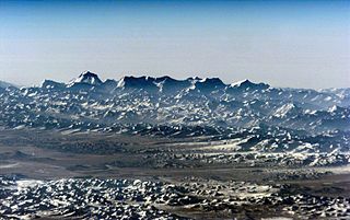
English: This stunning aerial view shows the rugged snow covered peaks of a Himalayan mountain range in Nepal. The seventh-highest peak on the planet, Dhaulagiri, is the high point on the horizon at the left while in the foreground lies the southern Tibetan Plateau of China. But, contrary to appearances, this picture wasn't taken from an airliner cruising at 30,000 feet. Instead it was taken with a 35mm camera and telephoto lens by the Expedition 1 crew aboard the International Space Station -- orbiting 200 nautical miles above the Earth. The Himalayan mountains were created by crustal plate tectonics on planet Earth some 70 million years ago, as the Indian plate began a collision with the Eurasian plate. Himalayan uplift still continues today at a rate of a few millimeters per year. |
| Petsa | |
| Gigikanan | http://apod.nasa.gov/apod/ap050528.html |
| Tagsulat | NASA/Expedition 1 |
Pagtugot
This file is in the public domain in the United States because it was created by the Image Science & Analysis Laboratory, of the NASA Johnson Space Center. NASA copyright policy states that "NASA material is not protected by copyright unless noted". (NASA media use guidelines or Conditions of Use of Astronaut Photographs).
Photo source: ISS001-E-6765.
|
| Annotations | This image is annotated: View the annotations at Commons |
Kaagi sa payl
I-klik ang petsa/oras aron makit-an ang hulagway sa payl niadtong panahona.
| Petsa/Takna | Thumbnail | Mga dimensyon | Tiggamit | Komento | |
|---|---|---|---|---|---|
| kasamtangan | 08:16, 22 Marso 2006 | | 1,530 × 960 (291 KB) | Tarawneh | {{Information| |Description= |Source= |Date= |Author= |Permission={{PD-USGov-NASA}} |other_versions= }} Category:Himalaya |
Mga paggamit sa payl
Ang mosunod nga 2 panid misumpay niining payl:
Global nga paggamit sa payl
Kining ubang wiki naggamit ning maong payl:
- Paggamit sa ca.wikipedia.org
- Paggamit sa cs.wikipedia.org
- Paggamit sa de.wikipedia.org
- Paggamit sa en.wikipedia.org
- Paggamit sa es.wikipedia.org
- Paggamit sa fa.wikipedia.org
- Paggamit sa fr.wikipedia.org
- Paggamit sa lld.wikipedia.org
- Paggamit sa nl.wikipedia.org
- Paggamit sa no.wikipedia.org
- Paggamit sa sk.wikipedia.org
- Paggamit sa sr.wikipedia.org
- Paggamit sa uk.wikipedia.org
- Paggamit sa www.wikidata.org