
Payl:Indonesia provinces english.png

Gidak-on ning maong paunang tan-aw: 800 x 365 ka mga piksel. Uban pang mga resoluyon: 320 x 146 ka mga piksel | 640 x 292 ka mga piksel | 1,628 x 742 ka mga piksel.
Tibuok resolusyon (1,628 × 742 pixels, size sa payl: 92 KB, MIME type: image/png)

|
File:Indonesia, administrative divisions - en - monochrome.svg is a vector version of this file. It should be used in place of this PNG file when not inferior.
File:Indonesia provinces english.png → File:Indonesia, administrative divisions - en - monochrome.svg
For more information, see Help:SVG. |
 |

|
This file requires updating because: In 2022, the Papua provinces changed from 2 provinces to 6 provinces. In doing so, you could add a timestamp to the file.
|
Mubong sugid:
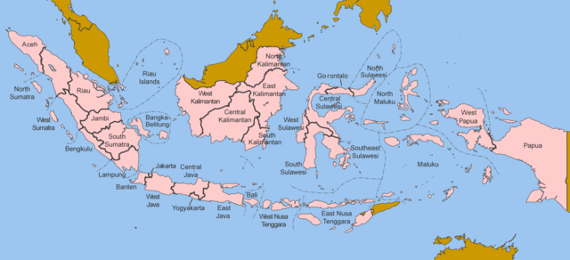
Map of the provinces of Indonesia in English.
Made by User:Golbez based on a PD CIA map, using other sources to guesstimate the extent of West Irian Jaya and West Sulawesi.
derivative works
Derivative works of this file: Indonesia, administrative divisions - en - monochrome.svg
Pagtugot
I, the copyright holder of this work, hereby publish it under the following licenses:

|
Gitugot ang pagkopya, pag-apud-apod o/ug pag-usab ning maong dokumento ubos sa mga termino sa GNU Free Documentation License, Version 1.2 o mas bag-ong bersiyon nga gimantala sa Free Software Foundation; nga walay Invariant Sections, walay Front-Cover Texts, ug walay Back-Cover Texts. Ang kopya sa lisensiya gilakip sa bahin nga giulohang GNU Free Documentation License. |
| This file is licensed under the Creative Commons Attribution-Share Alike 3.0 Unported license. | ||
| ||
| This licensing tag was added to this file as part of the GFDL licensing update. |
This file is licensed under the Creative Commons Attribution 2.5 Generic license.
- Libre ka:
- sa pagsabwag – sa pagkopya, pag-apod-apod ug pagsabwag sa hinimo
- sa pag-remix – sa pag-adap sa binuhat
- Ubos sa mosunod nga mga kondisyon:
- atribusyon – Kinahanglan nimo nga hatagan ang angay nga kredito, maghatag usa ka link sa lisensya, ug ipakita kung adunay mga pagbag-o. Mahimo nimo kini buhaton sa bisan unsang makatarunganon nga paagi, apan dili sa bisan unsang paagi nga nagsugyot nga gi-endorso ka sa licensor o ang imong paggamit.
You may select the license of your choice.
Kaagi sa payl
I-klik ang petsa/oras aron makit-an ang hulagway sa payl niadtong panahona.
| Petsa/Takna | Thumbnail | Mga dimensyon | Tiggamit | Komento | |
|---|---|---|---|---|---|
| kasamtangan | 12:40, 25 Oktubre 2020 | | 1,628 × 742 (92 KB) | Afrogindahood | Addition of North Kalimantan province |
| 07:54, 8 Enero 2006 | 1,500 × 590 (77 KB) | Golbez | Map of the provinces of Indonesian in English. Made by User:Golbez based on a PD CIA map, using other sources to guesstimate the extent of West Irian Jaya and West Sulawesi. Category:Maps of Indonesia |
Mga paggamit sa payl
Ang mosunod nga mga panid misumpay niining payl:
Global nga paggamit sa payl
Kining ubang wiki naggamit ning maong payl:
- Paggamit sa arz.wikipedia.org
- Paggamit sa ba.wikipedia.org
- Paggamit sa be-tarask.wikipedia.org
- Paggamit sa blk.wikipedia.org
- Paggamit sa bxr.wikipedia.org
- Paggamit sa ca.wikipedia.org
- Paggamit sa crh.wikipedia.org
- Paggamit sa csb.wikipedia.org
- Paggamit sa cs.wikipedia.org
- Paggamit sa cy.wikipedia.org
- Paggamit sa da.wikipedia.org
- Paggamit sa diq.wikipedia.org
- Paggamit sa dv.wikipedia.org
- Paggamit sa en.wikipedia.org
- Paggamit sa es.wikipedia.org
- Paggamit sa fr.wikipedia.org
- Paggamit sa gd.wikipedia.org
- Paggamit sa gl.wikipedia.org
- Paggamit sa ht.wikipedia.org
- Paggamit sa hu.wikipedia.org
- Paggamit sa incubator.wikimedia.org
- Paggamit sa it.wikipedia.org
- Paggamit sa ja.wikipedia.org
- Paggamit sa kaa.wikipedia.org
- Paggamit sa kk.wikipedia.org
- Paggamit sa km.wikipedia.org
- Paggamit sa kn.wikipedia.org
- Paggamit sa kv.wikipedia.org
- Paggamit sa kw.wikipedia.org
- Paggamit sa lij.wikipedia.org
- Paggamit sa lmo.wikipedia.org
- Paggamit sa ln.wikipedia.org
- Paggamit sa lv.wikipedia.org
- Paggamit sa mg.wikipedia.org
- Paggamit sa mhr.wikipedia.org
- Paggamit sa ml.wikipedia.org
- Paggamit sa mn.wikipedia.org
- Paggamit sa my.wikipedia.org
- Paggamit sa mzn.wikipedia.org
- Paggamit sa new.wikipedia.org
- Paggamit sa nl.wikipedia.org
- Paggamit sa nn.wikipedia.org
- Paggamit sa pag.wikipedia.org
- Paggamit sa pam.wikipedia.org
- Paggamit sa pap.wikipedia.org
- Paggamit sa pms.wikipedia.org
- Paggamit sa pnb.wikipedia.org
- Paggamit sa qu.wikipedia.org
View more global usage of this file.