
Payl:Kassite Babylonia EN.svg

Size of this PNG preview of this SVG file: 661 x 580 ka mga piksel. Uban pang mga resoluyon: 274 x 240 ka mga piksel | 547 x 480 ka mga piksel | 875 x 768 ka mga piksel | 1,167 x 1,024 ka mga piksel | 2,334 x 2,048 ka mga piksel.
Tibuok resolusyon (SVG nga payl, nominally 661 × 580 pixels, size sa payl: 183 KB)
Mubong sugid:
| Deskripsyon |
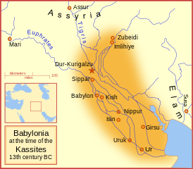
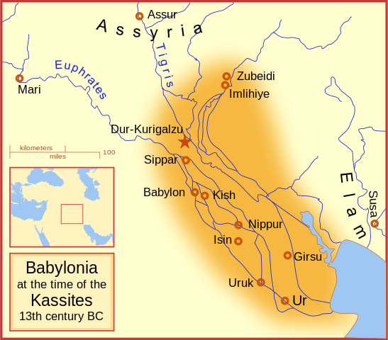
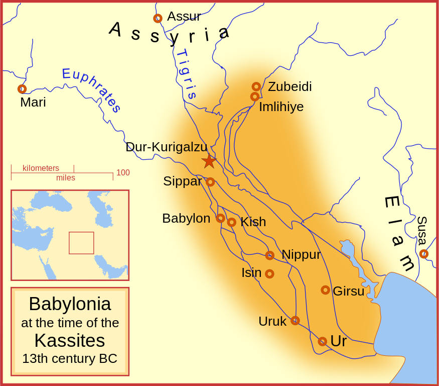
English: A map of the Babylonian Empire during the time of the Kassites, roughly the 13th century BC. This map shows the probable river courses and coastline at that time. Català: Babilònia durant la dinastia cassita (s. XIII aC) |
|||||
| Petsa | ||||||
| Gigikanan | Kaugalingong trabaho | |||||
| Tagsulat | MapMaster | |||||
| Other versions |
File:Kassite Babylonia EN.svg has 5 translations.
|


Other versions
Similar maps
References
- Roaf, M. (1990) Cultural Atlas of Mesopotamia and the ancient Near East, Oxford: Facts on File. (In general, the basis for the ancient river courses and ancient coastline).
Pagtugot
I, the copyright holder of this work, hereby publish it under the following licenses:

|
Gitugot ang pagkopya, pag-apud-apod o/ug pag-usab ning maong dokumento ubos sa mga termino sa GNU Free Documentation License, Version 1.2 o mas bag-ong bersiyon nga gimantala sa Free Software Foundation; nga walay Invariant Sections, walay Front-Cover Texts, ug walay Back-Cover Texts. Ang kopya sa lisensiya gilakip sa bahin nga giulohang GNU Free Documentation License. |
This file is licensed under the Creative Commons Attribution-Share Alike 4.0 International, 3.0 Unported, 2.5 Generic, 2.0 Generic and 1.0 Generic license.
- Libre ka:
- sa pagsabwag – sa pagkopya, pag-apod-apod ug pagsabwag sa hinimo
- sa pag-remix – sa pag-adap sa binuhat
- Ubos sa mosunod nga mga kondisyon:
- atribusyon – Kinahanglan nimo nga hatagan ang angay nga kredito, maghatag usa ka link sa lisensya, ug ipakita kung adunay mga pagbag-o. Mahimo nimo kini buhaton sa bisan unsang makatarunganon nga paagi, apan dili sa bisan unsang paagi nga nagsugyot nga gi-endorso ka sa licensor o ang imong paggamit.
- share parehas – Kung imong gi-remix, gibag-o, o gibase sa materyal, kinahanglan nimo nga iapod-apod ang imong mga kontribusyon sa ilawom sa parehas o katugma nga lisensya sama sa orihinal.
You may select the license of your choice.
Kaagi sa payl
I-klik ang petsa/oras aron makit-an ang hulagway sa payl niadtong panahona.
| Petsa/Takna | Thumbnail | Mga dimensyon | Tiggamit | Komento | |
|---|---|---|---|---|---|
| kasamtangan | 06:54, 20 Septiyembre 2023 | | 661 × 580 (183 KB) | Jaumellecha | File uploaded using svgtranslate tool (https://svgtranslate.toolforge.org/). Added translation for ca. |
| 17:39, 3 Marso 2008 |  | 661 × 580 (177 KB) | MapMaster | {{Information |Description=A map of the Babylonian Empire during the time of the Kassites, roughly the 13th century BC |Source=self-made |Date=3 March 2008 |Author= MapMaster |Permission= |other_versions= }} |
Mga paggamit sa payl
Ang mosunod nga mga panid misumpay niining payl:
Global nga paggamit sa payl
Kining ubang wiki naggamit ning maong payl:
- Paggamit sa ar.wikipedia.org
- Paggamit sa azb.wikipedia.org
- Paggamit sa az.wikipedia.org
- Paggamit sa be.wikipedia.org
- Paggamit sa bg.wikipedia.org
- Paggamit sa br.wikipedia.org
- Paggamit sa ca.wikipedia.org
- Paggamit sa ckb.wikipedia.org
- Paggamit sa cs.wikipedia.org
- Paggamit sa cv.wikipedia.org
- Paggamit sa de.wikipedia.org
- Paggamit sa en.wikipedia.org
- Babylonia
- Kassites
- Amarna Period
- List of conflicts in Asia
- Kassite dynasty
- Middle Babylonian period
- User:SomeGuyWhoRandomlyEdits/List of conflicts in the Near East
- Renaissance of Sumer
- User:A.X.Wiki.Editor/Middle Babylonian period
- User:A.X.Wiki.Editor/List of conflicts in Iraq
- User:SomeGuyWhoRandomlyEdits/Kassite dynasty
- Paggamit sa en.wikibooks.org
- Paggamit sa fa.wikipedia.org
- Paggamit sa fa.wikibooks.org
- Paggamit sa fi.wikipedia.org
- Paggamit sa fr.wiktionary.org
- Paggamit sa he.wikipedia.org
- Paggamit sa hr.wikipedia.org
- Paggamit sa id.wikipedia.org
View more global usage of this file.