
Payl:Kaufman County Texas Incorporated Areas Forney highlighted.svg

Size of this PNG preview of this SVG file: 800 x 440 ka mga piksel. Uban pang mga resoluyon: 320 x 176 ka mga piksel | 640 x 352 ka mga piksel | 1,024 x 563 ka mga piksel | 1,280 x 704 ka mga piksel | 2,560 x 1,408 ka mga piksel | 1,000 x 550 ka mga piksel.
Tibuok resolusyon (SVG nga payl, nominally 1,000 × 550 pixels, size sa payl: 190 KB)
Mubong sugid:
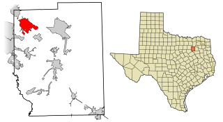
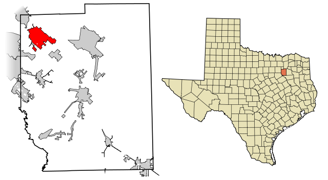
| Deskripsyon | This map shows the incorporated areas in Kaufman County, Texas. Forney is highlighted in red. I created it in Inkscape using data from the Kaufman County GIS Website) and the North Central Texas Council of Governments Website. |
| Petsa | |
| Gigikanan | My own work, based on government information. Though I strove to be as accurate in the detail as possible, the information isn't one hundred percent accurate. |
| Tagsulat | Ixnayonthetimmay |
| Pagtugot (Paggamit pag-usab niini nga file) |
Public Domain |
| Other versions | See Category:Maps of Kaufman County, Texas for other versions of this image. |
Pagtugot
| I, the copyright holder of this work, release this work into the public domain. This applies worldwide. In some countries this may not be legally possible; if so: I grant anyone the right to use this work for any purpose, without any conditions, unless such conditions are required by law. |
Kaagi sa payl
I-klik ang petsa/oras aron makit-an ang hulagway sa payl niadtong panahona.
| Petsa/Takna | Thumbnail | Mga dimensyon | Tiggamit | Komento | |
|---|---|---|---|---|---|
| kasamtangan | 06:15, 1 Marso 2008 | | 1,000 × 550 (190 KB) | Ixnayonthetimmay | == Summary == {{Information |Description=This map shows the incorporated areas in Kaufman County, Texas. Forney is highlighted in red. I created it in [[:en:Inkscape|In |
Mga paggamit sa payl
Ang mosunod nga mga panid misumpay niining payl:
Global nga paggamit sa payl
Kining ubang wiki naggamit ning maong payl:
- Paggamit sa arz.wikipedia.org
- Paggamit sa ca.wikipedia.org
- Paggamit sa cy.wikipedia.org
- Paggamit sa de.wikipedia.org
- Paggamit sa en.wikipedia.org
- Paggamit sa eu.wikipedia.org
- Paggamit sa fa.wikipedia.org
- Paggamit sa fr.wikipedia.org
- Paggamit sa ht.wikipedia.org
- Paggamit sa it.wikipedia.org
- Paggamit sa sr.wikipedia.org
- Paggamit sa tt.wikipedia.org
- Paggamit sa www.wikidata.org
- Paggamit sa zh-min-nan.wikipedia.org