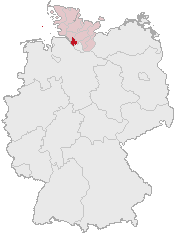
Payl:Lage des Kreises Pinneberg in Deutschland.png
Lage_des_Kreises_Pinneberg_in_Deutschland.png (176 × 234 pixels, size sa payl: 4 KB, MIME type: image/png)
Kaagi sa payl
I-klik ang petsa/oras aron makit-an ang hulagway sa payl niadtong panahona.
| Petsa/Takna | Thumbnail | Mga dimensyon | Tiggamit | Komento | |
|---|---|---|---|---|---|
| kasamtangan | 12:21, 5 Abril 2007 |  | 176 × 234 (4 KB) | Ditschi | transparent |
| 09:19, 3 Marso 2006 |  | 176 × 234 (4 KB) | Rauenstein | Karte erstellt auf der Grundlage der opengeodb.de-Umrisse - GNU-FDL Geograv 00:54, 31. Dez 2004 {{Bild-GFDL}} Category:Maps of Germany |
Mga paggamit sa payl
Ang mosunod nga mga panid misumpay niining payl:
Global nga paggamit sa payl
Kining ubang wiki naggamit ning maong payl:
- Paggamit sa ace.wikipedia.org
- Paggamit sa am.wikipedia.org
- Paggamit sa ang.wikipedia.org
- Paggamit sa arc.wikipedia.org
- Paggamit sa av.wikipedia.org
- Paggamit sa ay.wikipedia.org
- Paggamit sa bcl.wikipedia.org
- Paggamit sa bi.wikipedia.org
- Paggamit sa bm.wikipedia.org
- Paggamit sa bpy.wikipedia.org
- Paggamit sa bxr.wikipedia.org
- Paggamit sa cbk-zam.wikipedia.org
- Paggamit sa ch.wikipedia.org
- Paggamit sa cr.wikipedia.org
- Paggamit sa cs.wikipedia.org
- Paggamit sa cu.wikipedia.org
- Paggamit sa cv.wikipedia.org
- Paggamit sa cy.wikipedia.org
- Paggamit sa dsb.wikipedia.org
- Paggamit sa dv.wikipedia.org
- Paggamit sa dz.wikipedia.org
- Paggamit sa eml.wikipedia.org
- Paggamit sa eo.wikipedia.org
- Paggamit sa es.wikipedia.org
- Paggamit sa ext.wikipedia.org
- Paggamit sa ff.wikipedia.org
- Paggamit sa fiu-vro.wikipedia.org
- Paggamit sa fj.wikipedia.org
- Paggamit sa fo.wikipedia.org
- Paggamit sa frp.wikipedia.org
- Paggamit sa frr.wikipedia.org
- Paggamit sa fr.wikipedia.org
- Paggamit sa fur.wikipedia.org
- Paggamit sa fy.wikipedia.org
- Paggamit sa gag.wikipedia.org
- Paggamit sa gn.wikipedia.org
- Paggamit sa got.wikipedia.org
- Paggamit sa hak.wikipedia.org
- Paggamit sa haw.wikipedia.org
- Paggamit sa hif.wikipedia.org
- Paggamit sa hi.wikipedia.org
- Paggamit sa hr.wikipedia.org
- Paggamit sa ht.wikipedia.org
- Paggamit sa hy.wikipedia.org
- Paggamit sa id.wikipedia.org
- Paggamit sa ie.wikipedia.org
- Paggamit sa incubator.wikimedia.org
View more global usage of this file.

