
Payl:Lee County Alabama Incorporated and Unincorporated areas Loachapoka Highlighted2008.svg

Size of this PNG preview of this SVG file: 750 x 350 ka mga piksel. Uban pang mga resoluyon: 320 x 149 ka mga piksel | 640 x 299 ka mga piksel | 1,024 x 478 ka mga piksel | 1,280 x 597 ka mga piksel | 2,560 x 1,195 ka mga piksel.
Tibuok resolusyon (SVG nga payl, nominally 750 × 350 pixels, size sa payl: 141 KB)
Mubong sugid:
| Deskripsyon |
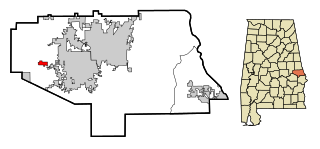
English: This map shows the incorporated and unincorporated areas in en:Lee County, Alabama, highlighting Loachapoka in red. It was created in Inkscape. |
| Petsa |
27 Enero 2008 (original upload date) |
| Gigikanan | My own work, based on similar map concepts by Ixnayonthetimmay. |
| Tagsulat | (Original text: Lissoy) |
Pagtugot
Lissoy from en.wikipedia.org, the copyright holder of this work, hereby publishes it under the following license:

|
Gitugot ang pagkopya, pag-apud-apod o/ug pag-usab ning maong dokumento ubos sa mga termino sa GNU Free Documentation License, Version 1.2 o mas bag-ong bersiyon nga gimantala sa Free Software Foundation; nga walay Invariant Sections, walay Front-Cover Texts, ug walay Back-Cover Texts. Ang kopya sa lisensiya gilakip sa bahin nga giulohang GNU Free Documentation License. |
| This file is licensed under the Creative Commons Attribution-Share Alike 3.0 Unported license. | ||
| Attribution: Lissoy | ||
| ||
| This licensing tag was added to this file as part of the GFDL licensing update. |
Lissoy at the English Wikipedia, the copyright holder of this work, hereby publishes it under the following license:
|
|
Gitugot ang pagkopya, pag-apud-apod o/ug pag-usab ning maong dokumento ubos sa mga termino sa GNU Free Documentation License, Version 1.2 o mas bag-ong bersiyon nga gimantala sa Free Software Foundation; nga walay Invariant Sections, walay Front-Cover Texts, ug walay Back-Cover Texts. Ang kopya sa lisensiya gilakip sa bahin nga giulohang GNU Free Documentation License. |
Original upload log
Transferred from en.wikipedia to Commons by Jalo.
The original description page was here. All following user names refer to en.wikipedia.
- 2008-01-27 18:29 Lissoy 750×350×0 (144138 bytes) {{Information |Description=This map shows the incorporated and unincorporated areas in [[Lee County, Alabama]], highlighting [[Loachapoka, Alabama|Loachapoka]] in red. It was created in Inkscape. |Source=My own work, based on similar map concepts by [[Us
Kaagi sa payl
I-klik ang petsa/oras aron makit-an ang hulagway sa payl niadtong panahona.
| Petsa/Takna | Thumbnail | Mga dimensyon | Tiggamit | Komento | |
|---|---|---|---|---|---|
| kasamtangan | 22:40, 31 Marso 2008 | | 750 × 350 (141 KB) | File Upload Bot (Magnus Manske) | {{BotMoveToCommons|en.wikipedia}} {{Information |Description={{en|This map shows the incorporated and unincorporated areas in en:Lee County, Alabama, highlighting Loachapoka in red. It was created in Inkscape.}} |Source=T |
Mga paggamit sa payl
Ang mosunod nga mga panid misumpay niining payl:
Global nga paggamit sa payl
Kining ubang wiki naggamit ning maong payl:
- Paggamit sa ar.wikipedia.org
- Paggamit sa ca.wikipedia.org
- Paggamit sa cy.wikipedia.org
- Paggamit sa es.wikipedia.org
- Paggamit sa eu.wikipedia.org
- Paggamit sa fa.wikipedia.org
- Paggamit sa fr.wikipedia.org
- Paggamit sa ht.wikipedia.org
- Paggamit sa it.wikipedia.org
- Paggamit sa sr.wikipedia.org
- Paggamit sa tt.wikipedia.org
- Paggamit sa www.wikidata.org
- Paggamit sa zh-min-nan.wikipedia.org