
Payl:Manisa districts.png
Gidak-on ning maong paunang tan-aw: 776 x 600 ka mga piksel. Uban pang mga resoluyon: 311 x 240 ka mga piksel | 621 x 480 ka mga piksel | 994 x 768 ka mga piksel | 1,056 x 816 ka mga piksel.
Tibuok resolusyon (1,056 × 816 pixels, size sa payl: 40 KB, MIME type: image/png)
Mubong sugid:
- Credits
- Created by Rarelibra 16:36, 4 December 2006 (UTC) for public domain use, using MapInfo Professional v8.5 and various mapping resources.
- Edited by One Homo Sapiens Corrected text where İ,Ş,ı,ğ,or ş occurs in name. Source: [statoids-com]. Increased font size and enhanced color differences among adjacent districts.
Pagtugot
| I, the copyright holder of this work, release this work into the public domain. This applies worldwide. In some countries this may not be legally possible; if so: I grant anyone the right to use this work for any purpose, without any conditions, unless such conditions are required by law. |
Kaagi sa payl
I-klik ang petsa/oras aron makit-an ang hulagway sa payl niadtong panahona.
| Petsa/Takna | Thumbnail | Mga dimensyon | Tiggamit | Komento | |
|---|---|---|---|---|---|
| kasamtangan | 01:35, 29 Disyembre 2008 | | 1,056 × 816 (40 KB) | One Homo Sapiens | Corrected text where İ,Ş,ı,ğ,or ş occurs in name. Source: [statoids-com]. Increased font size and enhanced color differences among adjacent districts. |
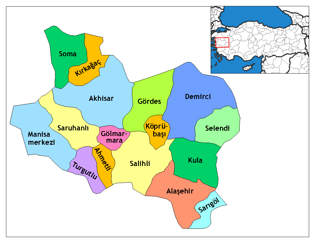
| 16:36, 4 Disyembre 2006 |  | 1,056 × 816 (35 KB) | Rarelibra | Map of the districts of Manisa province in Turkey. Created by ~~~~ for public domain use, using MapInfo Professional v8.5 and various mapping resources. |
Mga paggamit sa payl
Ang mosunod nga 2 panid misumpay niining payl:
Global nga paggamit sa payl
Kining ubang wiki naggamit ning maong payl:
- Paggamit sa ar.wikipedia.org
- Paggamit sa arz.wikipedia.org
- Paggamit sa ast.wikipedia.org
- Paggamit sa azb.wikipedia.org
- Paggamit sa az.wikipedia.org
- Paggamit sa ca.wikipedia.org
- Paggamit sa ce.wikipedia.org
- Paggamit sa cs.wikipedia.org
- Paggamit sa diq.wikipedia.org
- Paggamit sa en.wikipedia.org
- Paggamit sa en.wiktionary.org
- Paggamit sa eo.wikipedia.org
- Paggamit sa es.wikipedia.org
View more global usage of this file.