
Payl:Map at millstaetter see.svg

Size of this PNG preview of this SVG file: 800 x 453 ka mga piksel. Uban pang mga resoluyon: 320 x 181 ka mga piksel | 640 x 363 ka mga piksel | 1,024 x 580 ka mga piksel | 1,280 x 725 ka mga piksel | 2,560 x 1,451 ka mga piksel | 1,313 x 744 ka mga piksel.
Tibuok resolusyon (SVG nga payl, nominally 1,313 × 744 pixels, size sa payl: 124 KB)
| Deskripsyon |
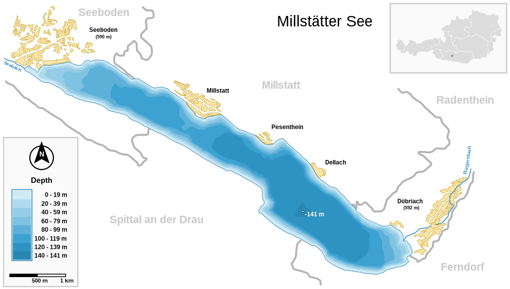
Deutsch: Millstätter See (Kärnten, Österreich) und wichtigste Ortschaften Seeboden / Millstatt / Pesenthein / Dellach / Döbriach
English: Millstätter See (Carinthia, Austria) with surrounding towns.
Français : Carte du lac Millstätter (Carinthie, Autriche) et des villes qui l'entourent. |
| Petsa | |
| Gigikanan | |
| Tagsulat | Michael Glanznig (Mglanznig) |
| Pagtugot (Paggamit pag-usab niini nga file) |
Creative Commons Attribution ShareAlike 2.0 Austria |
| Other versions | png |
| SVG genesis | This map is translated using SVG switch elements: all translations are stored in the same file. |
| Camera location | | View this and other nearby images on: OpenStreetMap |
|---|
|

This image was selected as picture of the day on Wikimedia Commons for 4 August 2006. It was captioned as follows: Other languages:
Cymraeg: Y Llyn Millstät (Millstätter See) (Carinthia, Awstria) gyda'i threfau amgylchoedd. Magyar: A Millstatti-tó (Karinthia, Ausztria) a környező falvakkal. Polski: Mapa Millstätter See (Karyntia, Austria) wraz z otaczającymi je miastami. Português: Millstätter See (Caríntia, Áustria) e cidades circundantes.. Русский: Мильшттское озеро (Millstätter See) в Каринтии, в Австрии: схема озера с прилежащими городами العربية : بحيرة ميلستيتير (كارينثيا النمسا) و البلدات المحيطة. |
I, the copyright holder of this work, hereby publish it under the following license:
This file is licensed under the Creative Commons Attribution-Share Alike 2.0 Austria license.
- Libre ka:
- sa pagsabwag – sa pagkopya, pag-apod-apod ug pagsabwag sa hinimo
- sa pag-remix – sa pag-adap sa binuhat
- Ubos sa mosunod nga mga kondisyon:
- atribusyon – Kinahanglan nimo nga hatagan ang angay nga kredito, maghatag usa ka link sa lisensya, ug ipakita kung adunay mga pagbag-o. Mahimo nimo kini buhaton sa bisan unsang makatarunganon nga paagi, apan dili sa bisan unsang paagi nga nagsugyot nga gi-endorso ka sa licensor o ang imong paggamit.
- share parehas – Kung imong gi-remix, gibag-o, o gibase sa materyal, kinahanglan nimo nga iapod-apod ang imong mga kontribusyon sa ilawom sa parehas o katugma nga lisensya sama sa orihinal.

Kaagi sa payl
I-klik ang petsa/oras aron makit-an ang hulagway sa payl niadtong panahona.
| Petsa/Takna | Thumbnail | Mga dimensyon | Tiggamit | Komento | |
|---|---|---|---|---|---|
| kasamtangan | 10:04, 27 Marso 2021 | | 1,313 × 744 (124 KB) | JoKalliauer | 1) width="1050pt" height="210mm" undefined behaviour (90 or 96 dpi) ; 2)<sodipodi:namedview pagecolor="#ffffff" replaced with <circle r="1e4" fill="#ffffff"/> and <rect width="100%" height="100%" fill="#ffffff"/>; 3) fonts replaced by fallback-fonts |
| 18:47, 10 Hunyo 2019 |  | 1,313 × 744 (239 KB) | Djiboun | File uploaded using svgtranslate tool (http://tools.wmflabs.org/svgtranslate/). Added translation for fr. | |
| 10:01, 16 Abril 2006 |  | 1,313 × 744 (238 KB) | Mglanznig | names for creeks | |
| 07:50, 15 Abril 2006 |  | 1,313 × 744 (236 KB) | Mglanznig | refinements | |
| 21:06, 13 Abril 2006 |  | 1,313 × 744 (233 KB) | Mglanznig | more svg rendering errors, praise Inkscape | |
| 20:43, 13 Abril 2006 |  | 1,313 × 744 (237 KB) | Mglanznig | svg errors corrected | |
| 20:35, 13 Abril 2006 |  | 1,313 × 744 (236 KB) | Mglanznig | ;Description : {{de|Millstätter See und wichtigste Ortschaften, Kärnten, Österreich}} {{en|Millstätter See with main towns, Carinthia, Austria}} ;Source : {{de|selbst zusammengestellt; Geodaten von [http://www.map24.com Map24] und [http://www.kagis.kt |
Mga paggamit sa payl
Ang mosunod nga mga panid misumpay niining payl:
Global nga paggamit sa payl
Kining ubang wiki naggamit ning maong payl:
- Paggamit sa arz.wikipedia.org
- Paggamit sa be.wikipedia.org
- Paggamit sa de.wikipedia.org
- Paggamit sa el.wikipedia.org
- Paggamit sa en.wikipedia.org
- Paggamit sa eo.wikipedia.org
- Paggamit sa fr.wikipedia.org
- Paggamit sa hu.wikipedia.org
- Paggamit sa hy.wikipedia.org
- Paggamit sa ia.wikipedia.org
- Paggamit sa id.wikipedia.org
- Paggamit sa ko.wikipedia.org
- Paggamit sa lv.wikipedia.org
- Paggamit sa nl.wikipedia.org
- Paggamit sa nl.wikibooks.org
- Paggamit sa nn.wikipedia.org
- Paggamit sa pl.wikipedia.org
- Paggamit sa pt.wikipedia.org
- Paggamit sa ru.wikipedia.org
- Paggamit sa ru.wikinews.org
- Paggamit sa su.wikipedia.org
- Paggamit sa uk.wikipedia.org
- Paggamit sa www.wikidata.org