
Payl:Map of Alaska highlighting Northwest Arctic Borough.svg

Size of this PNG preview of this SVG file: 800 x 423 ka mga piksel. Uban pang mga resoluyon: 320 x 169 ka mga piksel | 640 x 338 ka mga piksel | 1,024 x 541 ka mga piksel | 1,280 x 677 ka mga piksel | 2,560 x 1,353 ka mga piksel | 1,470 x 777 ka mga piksel.
Tibuok resolusyon (SVG nga payl, nominally 1,470 × 777 pixels, size sa payl: 338 KB)
Mubong sugid:
| Deskripsyon |
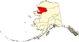
English: This is a locator map showing Northwest Arctic Borough in Alaska |
| Petsa | |
| Gigikanan |
Kaugalingong trabaho: English: The maps use data from nationalatlas.gov, specifically countyp020.tar.gz on the Raw Data Download page. The maps also use state outline data from statesp020.tar.gz. The Florida maps use hydrogm020.tar.gz to display Lake Okeechobee. |
| Tagsulat | David Benbennick |
Pagtugot
| I, the copyright holder of this work, release this work into the public domain. This applies worldwide. In some countries this may not be legally possible; if so: I grant anyone the right to use this work for any purpose, without any conditions, unless such conditions are required by law. |
Kaagi sa payl
I-klik ang petsa/oras aron makit-an ang hulagway sa payl niadtong panahona.
| Petsa/Takna | Thumbnail | Mga dimensyon | Tiggamit | Komento | |
|---|---|---|---|---|---|
| kasamtangan | 19:28, 5 Marso 2006 | | 1,470 × 777 (338 KB) | David Benbennick | {{subst:User:Dbenbenn/clm|county=Northwest Arctic Borough|state=Alaska|type=borough and census area}} |
Mga paggamit sa payl
Ang mosunod nga mga panid misumpay niining payl:
Global nga paggamit sa payl
Kining ubang wiki naggamit ning maong payl:
- Paggamit sa az.wikipedia.org
- Paggamit sa bpy.wikipedia.org
- Paggamit sa ca.wikipedia.org
- Paggamit sa ce.wikipedia.org
- Paggamit sa cy.wikipedia.org
- Paggamit sa de.wikipedia.org
- Paggamit sa en.wikipedia.org
- List of boroughs and census areas in Alaska
- Northwest Arctic Borough, Alaska
- Ambler, Alaska
- Buckland, Alaska
- Deering, Alaska
- Kiana, Alaska
- Kivalina, Alaska
- Kobuk, Alaska
- Kotzebue, Alaska
- Noatak, Alaska
- Noorvik, Alaska
- Red Dog Mine, Alaska
- Selawik, Alaska
- Shungnak, Alaska
- Iñupiat
- Kiwalik, Alaska
- Kotzebue Sound
- Selawik River
- Baldwin Peninsula
- Cape Krusenstern
- Kivalina River
- Hogatza River
- Selawik Lake
- Wikipedia:WikiProject Alaska
- Chamisso Wilderness
- Buckland River
- Nigu River
- Squirrel River
- Walker Lake (Northwest Arctic, Alaska)
View more global usage of this file.