
Payl:Naajaat panorama 2007-08-09 2 cropped USM downsampled edit.jpg

Gidak-on ning maong paunang tan-aw: 800 x 172 ka mga piksel. Uban pang mga resoluyon: 320 x 69 ka mga piksel | 640 x 138 ka mga piksel | 1,024 x 220 ka mga piksel | 1,280 x 275 ka mga piksel | 5,224 x 1,124 ka mga piksel.
Tibuok resolusyon (5,224 × 1,124 pixels, size sa payl: 6.43 MB, MIME type: image/jpeg)
Mubong sugid:
| Deskripsyon |
Dansk: Panorama ud over den lille nordvestgrønlandske bydg Naajaat. I baggrunden til venstre ses indlandsisen. Panoramaet er skabt i PTGui med Smartblend ud fra håndholdte billeder taget med et Canon IXUS 800 IS kompaktkamera.
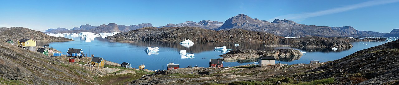
English: Panorama of the small settlement Naajaat in North-West Greenland. The Greenland ice sheet is seen to the upper left. The panoramic is based on hand-held photos taken with a Canon IXUS 800 IS compact camera. The stiching was done in PTGui with Smartblend.
Español: Vista panorámica del pueblo de Naajaat en el noroeste de Groenlandia (9 de agosto de 2007). Se puede ver la capa de hielo en la parte superior izquierda.
Français : Le village de Naajaat dans le Nord-Ouest du Groenland. On peut voir la calotte glaciaire en haut à gauche. Image panoramique obtenue en utilisant PTGui à partir de photos réalisées avec un appareil photo digital compact Canon IXUS 800 IS.
Українська: Невеличке поселення Нааяат у північно-західній Ґренландії, 9 серпня, 2007. У лівому верхньому куті видно Ґренландський льодовиковий щит
Português: Vista panorâmica do assentamento de Naajaat no noroeste da Groenlândia (9 de agosto de 2007). Pode-se ver o manto de gelo no canto superior esquerdo.
Bosanski: Malehno naselje Naajaat na sjeverozapadu Grenlanda 9. augusta 2007. Na gornjem lijevo uglu vidljiv je i dio grenlandskog ledenog štita.
Čeština: Malá osada Naajaat v severozápadním Grónsku, 9. srpna, 2007. Na snímku nahoře vlevo je patrný Grónský ledovec.
Magyar: A nyugat-grönlandi Naajaat település látképe. Bal felső sarokban a grönlandi jégtakaró látható
|
| Petsa |
|
| Gigikanan | |
| Tagsulat |
|
| Camera location | | View this and other nearby images on: OpenStreetMap |
|---|
| This is a retouched picture, which means that it has been digitally altered from its original version. Modifications: Exposure clipping removed. The original can be viewed here: Naajaat panorama 2007-08-09 2 cropped USM downsampled.jpg:
|
This image was selected as picture of the day on Wikimedia Commons for 8 August 2015. It was captioned as follows: English: The small settlement Naajaat in Northwest Greenland, August 9, 2007. The Greenland ice sheet is seen to the upper left. Other languages:
Bosanski: Malehno naselje Naajaat na sjeverozapadu Grenlanda 9. augusta 2007. Na gornjem lijevo uglu vidljiv je i dio grenlandskog ledenog štita. Čeština: Malá osada Naajaat v severozápadním Grónsku, 9. srpna, 2007. Na snímku nahoře vlevo je patrný Grónský ledovec. English: The small settlement Naajaat in Northwest Greenland, August 9, 2007. The Greenland ice sheet is seen to the upper left. Español: Vista panorámica del pueblo de Naajaat en el noroeste de Groenlandia (9 de agosto de 2007). Se puede ver la capa de hielo en la parte superior izquierda. Magyar: A nyugat-grönlandi Naajaat település látképe. Bal felső sarokban a grönlandi jégtakaró látható Nederlands: De kleine nederzetting Naajaat in noordwest Groenland met linksachter in beeld de Groenlandse ijskap. Português: Vista panorâmica do assentamento de Naajaat no noroeste da Groenlândia (9 de agosto de 2007). Pode-se ver o manto de gelo no canto superior esquerdo. Українська: Невеличке поселення Нааяат у північно-західній Ґренландії, 9 серпня, 2007. У лівому верхньому куті видно Ґренландський льодовиковий щит |
|
Pagtugot
I, the copyright holder of this work, hereby publish it under the following licenses:
This file is licensed under the Creative Commons Attribution-Share Alike 3.0 Unported, 2.5 Generic, 2.0 Generic and 1.0 Generic license.
- Libre ka:
- sa pagsabwag – sa pagkopya, pag-apod-apod ug pagsabwag sa hinimo
- sa pag-remix – sa pag-adap sa binuhat
- Ubos sa mosunod nga mga kondisyon:
- atribusyon – Kinahanglan nimo nga hatagan ang angay nga kredito, maghatag usa ka link sa lisensya, ug ipakita kung adunay mga pagbag-o. Mahimo nimo kini buhaton sa bisan unsang makatarunganon nga paagi, apan dili sa bisan unsang paagi nga nagsugyot nga gi-endorso ka sa licensor o ang imong paggamit.
- share parehas – Kung imong gi-remix, gibag-o, o gibase sa materyal, kinahanglan nimo nga iapod-apod ang imong mga kontribusyon sa ilawom sa parehas o katugma nga lisensya sama sa orihinal.

|
Gitugot ang pagkopya, pag-apud-apod o/ug pag-usab ning maong dokumento ubos sa mga termino sa GNU Free Documentation License, Version 1.2 o mas bag-ong bersiyon nga gimantala sa Free Software Foundation; nga walay Invariant Sections, walay Front-Cover Texts, ug walay Back-Cover Texts. Ang kopya sa lisensiya gilakip sa bahin nga giulohang GNU Free Documentation License. |
You may select the license of your choice.
Original upload log
This image is a derivative work of the following images:
- File:Naajaat_panorama_2007-08-09_2_cropped_USM_downsampled.jpg licensed with Cc-by-sa-3.0,2.5,2.0,1.0, GFDL
- 2010-02-27T01:17:30Z Noodle snacks 5224x1124 (6667230 Bytes) selective sharpen a spot.
- 2010-02-27T01:15:41Z Noodle snacks 5224x1124 (6667230 Bytes) restitch
- 2007-12-21T22:05:48Z Slaunger 5900x1200 (2083239 Bytes) {{Information |Description= {{da|Panorama ud over den lille nordvestgrønlandske bydg [[:da:Naajaat|Naajaat]]. I baggrunden til venstre ses indlandsisen.}} {{en|Panorama of the small settlement [[w:Naajaat|Naajaat]] in North-
Uploaded with derivativeFX
| Annotations | This image is annotated: View the annotations at Commons |
Kaagi sa payl
I-klik ang petsa/oras aron makit-an ang hulagway sa payl niadtong panahona.
| Petsa/Takna | Thumbnail | Mga dimensyon | Tiggamit | Komento | |
|---|---|---|---|---|---|
| kasamtangan | 11:37, 28 Pebrero 2010 | 5,224 × 1,124 (6.43 MB) | Herbythyme | {{Information |Description={{da|Panorama ud over den lille nordvestgrønlandske bydg Naajaat. I baggrunden til venstre ses indlandsisen. Panoramaet er skabt i Hugin ud fra håndholdte billeder taget med et [[w:Canon |
Mga paggamit sa payl
Ang mosunod nga mga panid misumpay niining payl:
Global nga paggamit sa payl
Kining ubang wiki naggamit ning maong payl:
- Paggamit sa be-tarask.wikipedia.org
- Paggamit sa bg.wikipedia.org
- Paggamit sa bn.wikipedia.org
- Paggamit sa ca.wikipedia.org
- Paggamit sa crh.wikipedia.org
- Paggamit sa cs.wikipedia.org
- Paggamit sa cv.wikipedia.org
- Paggamit sa de.wikipedia.org
- Paggamit sa en.wikipedia.org
- Naajaat
- Wikipedia:Featured pictures/Places/Panorama
- User:Slaunger
- Talk:Naajaat
- User talk:Slaunger
- Wikipedia:Featured pictures thumbs/22
- Wikipedia:Featured picture candidates/Naajaat
- Wikipedia:Featured picture candidates/March-2010
- Wikipedia:Wikipedia Signpost/2010-03-08/Features and admins
- Upernavik Archipelago
- User talk:JJ Harrison/Archive3
- Wikipedia:Picture of the day/October 2011
- Template:POTD/2011-10-17
- Wikipedia:Main Page history/2011 October 17
- Portal:Islands/Selected picture
- Portal:Islands/Selected picture/8
- Wikipedia:Wikipedia Signpost/Single/2010-03-08
- Paggamit sa en.wikiversity.org
- Paggamit sa es.wikipedia.org
- Paggamit sa fa.wikipedia.org
- Paggamit sa fr.wikipedia.org
- Paggamit sa hu.wikipedia.org
- Paggamit sa ilo.wikipedia.org
- Plantilia:Napili a ladawan ita nga aldaw/Agosto 5
- Plantilia:Napili a ladawan ita nga aldaw/Oktubre 5
- Plantilia:Napili a ladawan ita nga aldaw/Disiembre 5
- Plantilia:Napili a ladawan ita nga aldaw/Pebrero 5
- Plantilia:Napili a ladawan ita nga aldaw/Abril 5
- Plantilia:Napili a ladawan ita nga aldaw/Hunio 5
- Paggamit sa it.wikipedia.org
- Paggamit sa iu.wikipedia.org
- Paggamit sa ka.wikipedia.org
- Paggamit sa kl.wikipedia.org
- Paggamit sa ko.wikipedia.org
- Paggamit sa krc.wikipedia.org
- Paggamit sa lbe.wikipedia.org
View more global usage of this file.