
Payl:Panama relief location map.jpg

Gidak-on ning maong paunang tan-aw: 800 x 403 ka mga piksel. Uban pang mga resoluyon: 320 x 161 ka mga piksel | 640 x 322 ka mga piksel | 1,024 x 516 ka mga piksel | 1,280 x 644 ka mga piksel | 2,187 x 1,101 ka mga piksel.
Tibuok resolusyon (2,187 × 1,101 pixels, size sa payl: 899 KB, MIME type: image/jpeg)
Mubong sugid:
| Deskripsyon |
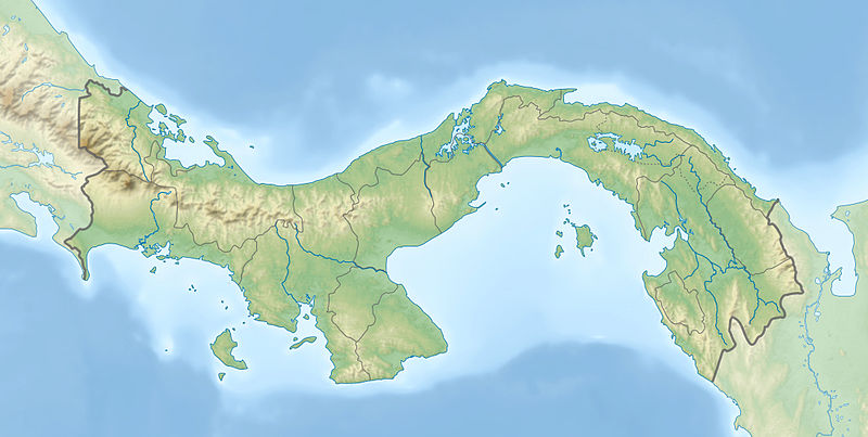
English: Physical location map of Panama
Equirectangular projection. Geographic limits of the map:
Deutsch: Physische Positionskarte von Panama
Quadratische Plattkarte. Geographische Begrenzung der Karte:
|
| Petsa | |
| Gigikanan |
Kaugalingong trabaho
|
| Tagsulat | Alexrk2 |
| Other versions |
|


|
This map has been made or improved in the German Kartenwerkstatt (Map Lab). You can propose maps to improve as well.
|
Pagtugot
I, the copyright holder of this work, hereby publish it under the following licenses:

|
Gitugot ang pagkopya, pag-apud-apod o/ug pag-usab ning maong dokumento ubos sa mga termino sa GNU Free Documentation License, Version 1.2 o mas bag-ong bersiyon nga gimantala sa Free Software Foundation; nga walay Invariant Sections, walay Front-Cover Texts, ug walay Back-Cover Texts. Ang kopya sa lisensiya gilakip sa bahin nga giulohang GNU Free Documentation License. |
This file is licensed under the Creative Commons Attribution-Share Alike 3.0 Unported license.
- Libre ka:
- sa pagsabwag – sa pagkopya, pag-apod-apod ug pagsabwag sa hinimo
- sa pag-remix – sa pag-adap sa binuhat
- Ubos sa mosunod nga mga kondisyon:
- atribusyon – Kinahanglan nimo nga hatagan ang angay nga kredito, maghatag usa ka link sa lisensya, ug ipakita kung adunay mga pagbag-o. Mahimo nimo kini buhaton sa bisan unsang makatarunganon nga paagi, apan dili sa bisan unsang paagi nga nagsugyot nga gi-endorso ka sa licensor o ang imong paggamit.
- share parehas – Kung imong gi-remix, gibag-o, o gibase sa materyal, kinahanglan nimo nga iapod-apod ang imong mga kontribusyon sa ilawom sa parehas o katugma nga lisensya sama sa orihinal.
You may select the license of your choice.
| Annotations | This image is annotated: View the annotations at Commons |
Kaagi sa payl
I-klik ang petsa/oras aron makit-an ang hulagway sa payl niadtong panahona.
| Petsa/Takna | Thumbnail | Mga dimensyon | Tiggamit | Komento | |
|---|---|---|---|---|---|
| kasamtangan | 18:04, 1 Enero 2014 | | 2,187 × 1,101 (899 KB) | NordNordWest | + Panama Oeste |
| 16:21, 22 Hulyo 2009 |  | 2,187 × 1,101 (785 KB) | Alexrk2 | Enhanced admin borders | |
| 14:00, 19 Hulyo 2009 |  | 2,186 × 1,101 (774 KB) | Alexrk2 | changed dim | |
| 13:53, 19 Hulyo 2009 |  | 2,186 × 1,101 (772 KB) | Alexrk2 | == Beschreibung == {{Information |Description={{en|1=Physical location map of Panama Equirectangular projection. Geographic limits of the map: * N: 10.28° N * S: 6.79° N * W: 83.56° W * O: 76.64° W}} {{de|1=Physische Positionskarte von |
Mga paggamit sa payl
Ang mosunod nga mga panid misumpay niining payl:
Global nga paggamit sa payl
Kining ubang wiki naggamit ning maong payl:
- Paggamit sa als.wikipedia.org
- Paggamit sa ar.wikipedia.org
- Paggamit sa arz.wikipedia.org
- Paggamit sa ast.wikipedia.org
- Paggamit sa avk.wikipedia.org
- Paggamit sa az.wikipedia.org
- Paggamit sa ban.wikipedia.org
- Paggamit sa ba.wikipedia.org
- Paggamit sa be-tarask.wikipedia.org
- Paggamit sa be.wikipedia.org
- Paggamit sa bg.wikipedia.org
- Paggamit sa bn.wikipedia.org
- Paggamit sa bs.wikipedia.org
- Paggamit sa ca.wikipedia.org
- Paggamit sa ce.wikipedia.org
- Paggamit sa ckb.wikipedia.org
- Paggamit sa cs.wikipedia.org
View more global usage of this file.