
Payl:Poitou-Charentes region location map.svg

Size of this PNG preview of this SVG file: 538 x 599 ka mga piksel. Uban pang mga resoluyon: 215 x 240 ka mga piksel | 431 x 480 ka mga piksel | 690 x 768 ka mga piksel | 920 x 1,024 ka mga piksel | 1,839 x 2,048 ka mga piksel | 1,136 x 1,265 ka mga piksel.
Tibuok resolusyon (SVG nga payl, nominally 1,136 × 1,265 pixels, size sa payl: 538 KB)
Mubong sugid:
| Camera location | | View this and other nearby images on: OpenStreetMap |
|---|
| Deskripsyon |
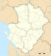
English: Blank administrative map of the region of Poitou-Charentes, France, for geo-location purpose, with distinct boundaries for regions, departments and arrondissements as set in 2008.
Français : Carte administrative vierge de la région Poitou-Charentes, France, destinée à la géolocalisation, avec limite distincte des régions, départements et arrondissements tels que définis en 2008. Approximate scale: 1:800,000 (precision: 200 m)
Geographic limits of the map:
|
||
| Petsa | |||
| Gigikanan |
Kaugalingong trabaho
|
||
| Tagsulat | Eric Gaba (Sting - fr:Sting) | ||
| Pagtugot (Paggamit pag-usab niini nga file) |
|
||
| Other versions |
|

Pagtugot
I, the copyright holder of this work, hereby publish it under the following licenses:
This file is licensed under the Creative Commons Attribution-Share Alike 3.0 Unported license.
- Libre ka:
- sa pagsabwag – sa pagkopya, pag-apod-apod ug pagsabwag sa hinimo
- sa pag-remix – sa pag-adap sa binuhat
- Ubos sa mosunod nga mga kondisyon:
- atribusyon – Kinahanglan nimo nga hatagan ang angay nga kredito, maghatag usa ka link sa lisensya, ug ipakita kung adunay mga pagbag-o. Mahimo nimo kini buhaton sa bisan unsang makatarunganon nga paagi, apan dili sa bisan unsang paagi nga nagsugyot nga gi-endorso ka sa licensor o ang imong paggamit.
- share parehas – Kung imong gi-remix, gibag-o, o gibase sa materyal, kinahanglan nimo nga iapod-apod ang imong mga kontribusyon sa ilawom sa parehas o katugma nga lisensya sama sa orihinal.

|
Gitugot ang pagkopya, pag-apud-apod o/ug pag-usab ning maong dokumento ubos sa mga termino sa GNU Free Documentation License, Version 1.2 o mas bag-ong bersiyon nga gimantala sa Free Software Foundation; nga walay Invariant Sections, walay Front-Cover Texts, ug walay Back-Cover Texts. Ang kopya sa lisensiya gilakip sa bahin nga giulohang GNU Free Documentation License. |
You may select the license of your choice.
Kaagi sa payl
I-klik ang petsa/oras aron makit-an ang hulagway sa payl niadtong panahona.
| Petsa/Takna | Thumbnail | Mga dimensyon | Tiggamit | Komento | |
|---|---|---|---|---|---|
| kasamtangan | 20:32, 14 Oktubre 2008 | | 1,136 × 1,265 (538 KB) | Sting | == Summary == {{Location|46|08|15|N|00|10|30|W|scale:2000000}} <br/> {{Information |Description={{en|Blank administrative map of the region of Poitou-Charentes, France, for geo-location purpose, with distinct boundaries for region |
Mga paggamit sa payl
Ang mosunod nga mga panid misumpay niining payl:
Global nga paggamit sa payl
Kining ubang wiki naggamit ning maong payl:
- Paggamit sa ar.wikipedia.org
- Paggamit sa bg.wikipedia.org
- Paggamit sa ca.wikipedia.org
- Paggamit sa cs.wikipedia.org
- Paggamit sa cv.wikipedia.org
- Paggamit sa de.wikipedia.org
- Paggamit sa el.wikipedia.org
- Paggamit sa en.wikipedia.org
- Paggamit sa eo.wikipedia.org
- Paggamit sa es.wikipedia.org
- Paggamit sa fa.wikipedia.org
- Paggamit sa fr.wikipedia.org
- Pictons
- Baptistère Saint-Jean de Poitiers
- Cathédrale Saint-Pierre de Poitiers
- Raids vikings en Poitou et dans la vallée de la Charente
- Modèle:Infobox Port
- Grand Pavois de La Rochelle
- Commanderie d'Ozon
- Abbaye de Saint-Savin-sur-Gartempe
- Église Notre-Dame-de-la-Couldre
- Tumulus de Bougon
- Abbaye Saint-Sauveur de Charroux
- Commanderie Saint-Antoine-de-la-Lande
- Musée Sainte-Croix
- Abbaye de Mauléon
- Pont Neuf (Poitiers)
- Modèle:Géolocalisation/Poitou-Charentes
- Modèle:Carte/Poitou-Charentes
- Wikipédia:Atelier graphique/Cartes/Archives/novembre 2008
- Gare de Lussac-les-Châteaux
- Gare de Mignaloux - Nouaillé
- Projet:Cartographie/Cartes standards/France
- Temple protestant de Saintes
- Basilique Notre-Dame-de-Pitié de La Chapelle-Saint-Laurent
View more global usage of this file.