
Payl:Sépulture de Teviec (5).jpg
Gidak-on ning maong paunang tan-aw: 800 x 533 ka mga piksel. Uban pang mga resoluyon: 320 x 213 ka mga piksel | 640 x 427 ka mga piksel | 1,024 x 683 ka mga piksel | 1,280 x 853 ka mga piksel | 2,560 x 1,707 ka mga piksel | 6,048 x 4,032 ka mga piksel.
Tibuok resolusyon (6,048 × 4,032 pixels, size sa payl: 19.3 MB, MIME type: image/jpeg)
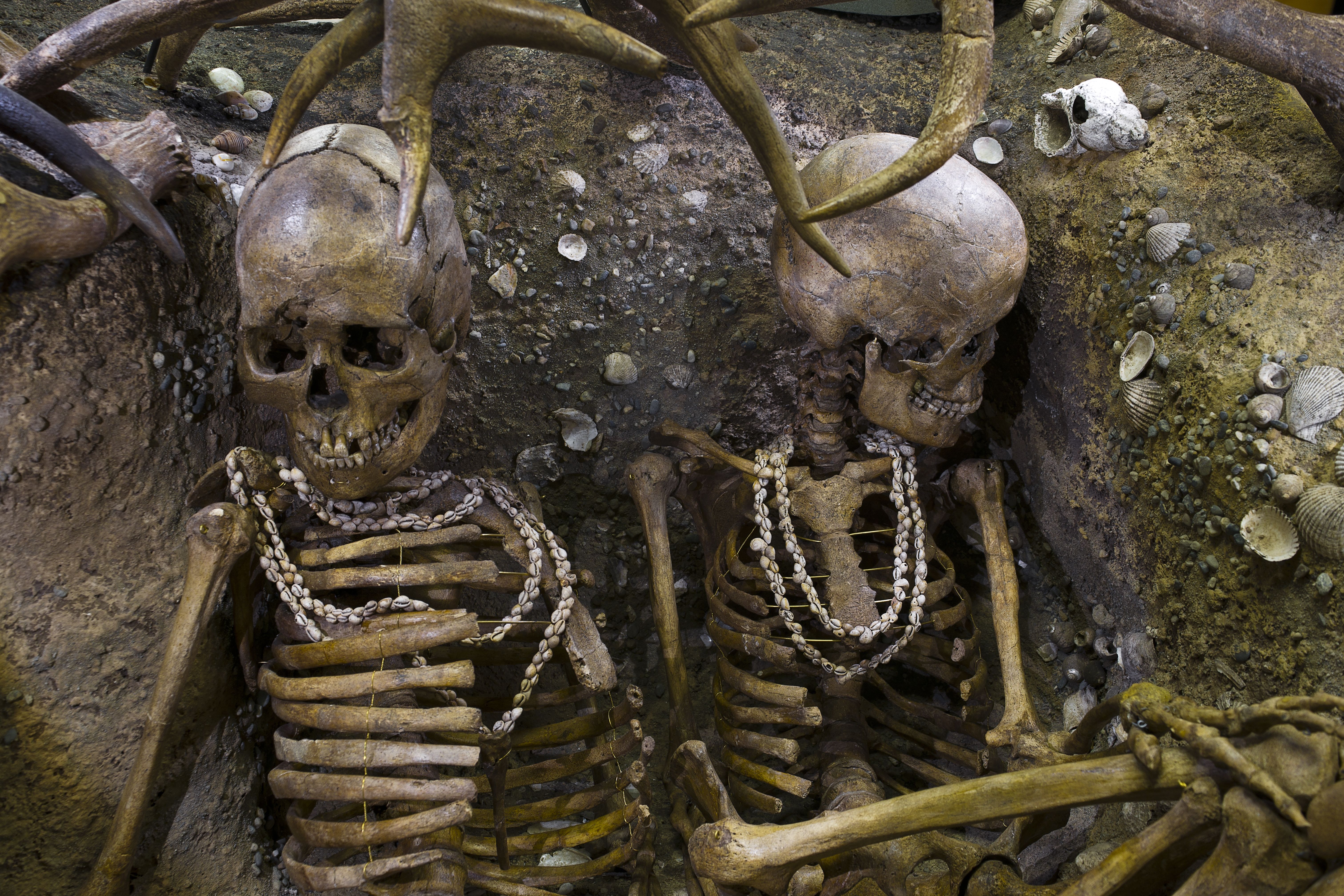
Burial of Teviec, Bretagne, France
Mubong sugid:
| Deskripsyon |
Tomb of Téviec. Two skeletons of a woman between 25 and 35 years, died a violent death, with several head injuries and impacts of arrows. The two bodies were buried with great care in a pit in the half basement and half in the kitchen debris that covered them. All protected by antler. The grave goods include flint and bone (mainly wild boar) offerings? and funeral jewelry which is made of marine shells drilled and assembled into necklaces, bracelets and ankle rings. Some of them have a few bone objects with engraved lines. Recovery in 1938 restoration 2010. |
|||||||||||||||||||||||
| Petsa | - 6740 - - 5680 BC (Mesolithic) | |||||||||||||||||||||||
| Collection |
|
|||||||||||||||||||||||
| Object history |
location of discovery: Théviec or Téviec, Saint-Pierre-Quiberon, Bretagne, France.. |
|||||||||||||||||||||||
| Source/Photographer |
Didier Descouens, 9 Oktubre 2010 I, the copyright holder of this work, hereby publish it under the following license: This file is licensed under the Creative Commons Attribution-Share Alike 4.0 International license.
|
|||||||||||||||||||||||
| Other versions |
|
|||||||||||||||||||||||


.jpg)
.jpg)
| Camera location | | View this and other nearby images on: OpenStreetMap |
|---|
.jpg¶ms=043.593897_N_0001.449230_E_globe:Earth_type:camera__&language=ceb)

|
This document was made as part of the Projet Phoebus.
|
Published in the press
Kaagi sa payl
I-klik ang petsa/oras aron makit-an ang hulagway sa payl niadtong panahona.
| Petsa/Takna | Thumbnail | Mga dimensyon | Tiggamit | Komento | |
|---|---|---|---|---|---|
| kasamtangan | 16:23, 9 Oktubre 2010 | | 6,048 × 4,032 (19.3 MB) | Archaeodontosaurus | {{Information |Description={{en|1=x}} |Source={{own}} |Author=Archaeodontosaurus |Date= |Permission= |other_versions= }} |
Mga paggamit sa payl
Ang mosunod nga mga panid misumpay niining payl:
Global nga paggamit sa payl
Kining ubang wiki naggamit ning maong payl:
- Paggamit sa ba.wikipedia.org
- Paggamit sa be.wikipedia.org
- Paggamit sa bg.wikipedia.org
- Paggamit sa br.wikipedia.org
- Paggamit sa ca.wikipedia.org
- Paggamit sa cs.wikipedia.org
- Paggamit sa cy.wikipedia.org
- Paggamit sa da.wikipedia.org
- Paggamit sa de.wikipedia.org
- Paggamit sa el.wikipedia.org
- Paggamit sa en.wikipedia.org
- Paggamit sa fa.wikipedia.org
- Paggamit sa fr.wikipedia.org
- Paggamit sa gl.wikipedia.org
- Paggamit sa hi.wikipedia.org
- Paggamit sa hr.wikipedia.org
- Paggamit sa hu.wikipedia.org
- Paggamit sa id.wikipedia.org
- Paggamit sa it.wikipedia.org
- Paggamit sa ja.wikipedia.org
- Paggamit sa ka.wikipedia.org
- Paggamit sa kk.wikipedia.org
- Paggamit sa ko.wikipedia.org
- Paggamit sa lt.wikipedia.org
- Paggamit sa mk.wikipedia.org
- Paggamit sa ms.wikipedia.org
- Paggamit sa ne.wikipedia.org
- Paggamit sa nl.wikipedia.org
- Paggamit sa ru.wikipedia.org
- Paggamit sa sh.wikipedia.org
- Paggamit sa simple.wikipedia.org
- Paggamit sa sl.wikipedia.org
- Paggamit sa sv.wikipedia.org
- Paggamit sa tr.wikipedia.org
- Paggamit sa uk.wikipedia.org
- Paggamit sa vls.wikipedia.org
- Paggamit sa xmf.wikipedia.org
- Paggamit sa zh.wikipedia.org
.jpg)