
Payl:Savoie department location map.svg

Size of this PNG preview of this SVG file: 714 x 600 ka mga piksel. Uban pang mga resoluyon: 286 x 240 ka mga piksel | 572 x 480 ka mga piksel | 915 x 768 ka mga piksel | 1,220 x 1,024 ka mga piksel | 2,439 x 2,048 ka mga piksel | 1,104 x 927 ka mga piksel.
Tibuok resolusyon (SVG nga payl, nominally 1,104 × 927 pixels, size sa payl: 164 KB)
Mubong sugid:
| Camera location | | View this and other nearby images on: OpenStreetMap |
|---|
| Deskripsyon |
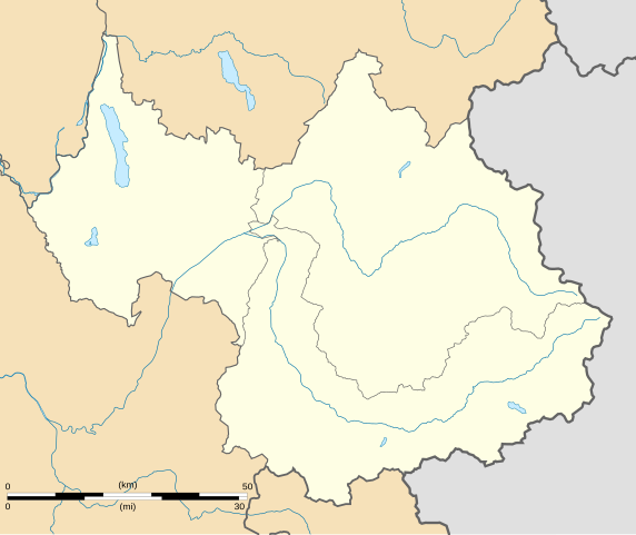
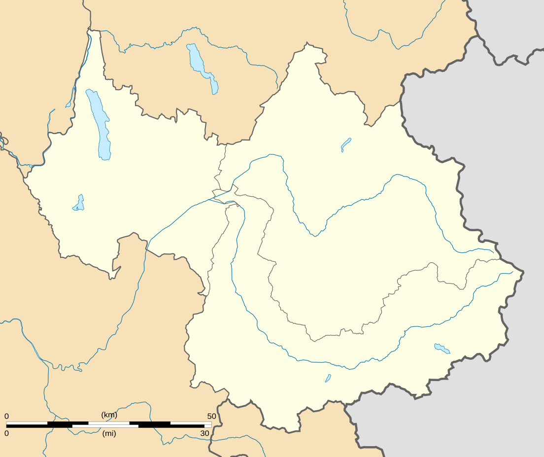
English: Blank administrative map of the department of Savoie, France, for geo-location purpose.
Scale : 1:800,000 (precision : 200 m) Français : Carte administrative vierge du département de la Savoie, France, destinée à la géolocalisation.
Échelle : 1:800 000 (précision : 200 m) Equirectangular projection, WGS84 datum
Geographic limits of the map :
|
||
| Petsa | |||
| Gigikanan |
Kaugalingong trabaho
|
||
| Tagsulat | Eric Gaba (Sting - fr:Sting) | ||
| Pagtugot (Paggamit pag-usab niini nga file) |
|
||
| Other versions |
Derivative works of this file: Territoires de la Savoie (CG73).PNG
|

.PNG)
Pagtugot
I, the copyright holder of this work, hereby publish it under the following licenses:
This file is licensed under the Creative Commons Attribution-Share Alike 3.0 Unported license.
- Libre ka:
- sa pagsabwag – sa pagkopya, pag-apod-apod ug pagsabwag sa hinimo
- sa pag-remix – sa pag-adap sa binuhat
- Ubos sa mosunod nga mga kondisyon:
- atribusyon – Kinahanglan nimo nga hatagan ang angay nga kredito, maghatag usa ka link sa lisensya, ug ipakita kung adunay mga pagbag-o. Mahimo nimo kini buhaton sa bisan unsang makatarunganon nga paagi, apan dili sa bisan unsang paagi nga nagsugyot nga gi-endorso ka sa licensor o ang imong paggamit.
- share parehas – Kung imong gi-remix, gibag-o, o gibase sa materyal, kinahanglan nimo nga iapod-apod ang imong mga kontribusyon sa ilawom sa parehas o katugma nga lisensya sama sa orihinal.

|
Gitugot ang pagkopya, pag-apud-apod o/ug pag-usab ning maong dokumento ubos sa mga termino sa GNU Free Documentation License, Version 1.2 o mas bag-ong bersiyon nga gimantala sa Free Software Foundation; nga walay Invariant Sections, walay Front-Cover Texts, ug walay Back-Cover Texts. Ang kopya sa lisensiya gilakip sa bahin nga giulohang GNU Free Documentation License. |
You may select the license of your choice.
Kaagi sa payl
I-klik ang petsa/oras aron makit-an ang hulagway sa payl niadtong panahona.
| Petsa/Takna | Thumbnail | Mga dimensyon | Tiggamit | Komento | |
|---|---|---|---|---|---|
| kasamtangan | 01:07, 4 Septiyembre 2008 | | 1,104 × 927 (164 KB) | Sting | Color of the lakes |
| 00:19, 5 Agosto 2008 |  | 1,104 × 927 (164 KB) | Sting | More precise boundaries | |
| 18:53, 30 Hulyo 2008 |  | 1,104 × 927 (124 KB) | Sting | + rivers ; int. boundary passing on top of Mont Blanc | |
| 18:06, 25 Hulyo 2008 |  | 1,104 × 927 (74 KB) | Sting | - border | |
| 23:40, 19 Hulyo 2008 |  | 1,104 × 927 (77 KB) | Sting | == Summary == {{Location|45|30|00|N|06|24|00|E|scale:1000000}} <br/> {{Information |Description={{en|Blank map of the department of Savoie, France, for geo-location purpose.<br/>Scale : 1:800,000 (precision : 200 m)}} {{fr|Carte vierge du d |
Mga paggamit sa payl
Ang mosunod nga mga panid misumpay niining payl:
Global nga paggamit sa payl
Kining ubang wiki naggamit ning maong payl:
- Paggamit sa als.wikipedia.org
- Paggamit sa ar.wikipedia.org
- Paggamit sa ban.wikipedia.org
- Paggamit sa bs.wikipedia.org
- Paggamit sa cs.wikipedia.org
- Paggamit sa da.wikipedia.org
- Paggamit sa de.wikipedia.org
- Paggamit sa el.wikipedia.org
- Paggamit sa en.wikipedia.org
- Lac du Bourget
- Vanoise National Park
- Lac de Lessy
- Lac de Tignes
- Lac d'Aiguebelette
- Lac des Évettes
- Wikipedia:WikiProject Maps/Conventions/Location maps
- Courchevel Altiport
- Talk:Battle of Kursk/Archive 2
- Molard Noir
- Wikipedia talk:WikiProject Maps/Archive 2009
- Le Chabichou
- Module:Location map/data/France Savoie/doc
- Module:Location map/data/France Savoie
- Wikipedia:WikiProject Maps/Conventions/Location maps (series N)
- Paggamit sa eo.wikipedia.org
- Montmélian
- Peisey-Nancroix
- La Chapelle (Savoie)
- Frontenex
- Ŝablono:Situo sur mapo Francio Savoie
- Bourg-Saint-Maurice
- Saint-Jean-de-Maurienne
- La Motte-Servolex
- Modane
- Tignes
- Valloire
- Bourg-Saint-Maurice (stacidomo)
- Aiguebelette-le-Lac
- Aillon-le-Jeune
- Aillon-le-Vieux
- Aime-la-Plagne
- Aiton (Savoie)
- Albiez-le-Jeune
- Albiez-Montrond
- Allondaz
- Les Allues
- Apremont (Savoie)
- Arbin
View more global usage of this file.