
Payl:Thatched Cottage and Maypole - geograph.org.uk - 314401.jpg
Walay mas taas nga resolusyon.
Thatched_Cottage_and_Maypole_-_geograph.org.uk_-_314401.jpg (640 × 480 pixels, size sa payl: 124 KB, MIME type: image/jpeg)
Mubong sugid:
| Deskripsyon |
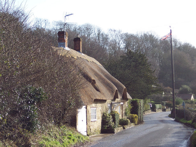
English: Thatched Cottage and Maypole Ansty is a very picturesque village with a large pond surrounded by the Manor House, cottages and ancient Commandery.
It has been the scene of May Day gatherings for over 1,000 years. The Maypole itself was a gift from the Arundells of Wardour Castle and replaced every twenty years - the present one is keeping with earlier tradition, still has a silver coin lodged beneath the weather vane. It is said that whoever is brave enough or foolhardy enough to climb the pole can keep it. Originally, tenants of the Wardour estate brought their children to meet each other and dance around the maypole every year. This gathering has continued annually for hundreds of years, except during 1644 to 1660 when Puritan officials removed the pole by government statute. |
| Petsa | |
| Gigikanan | From geograph.org.uk |
| Tagsulat | Trish Steel |
| Camera location | | View this and other nearby images on: OpenStreetMap |
|---|
_heading:135.00&language=ceb)
| Object location | | View this and other nearby images on: OpenStreetMap |
|---|
_heading:135.00&language=ceb)
Pagtugot

|
This image was taken from the Geograph project collection. See this photograph's page on the Geograph website for the photographer's contact details. The copyright on this image is owned by Trish Steel and is licensed for reuse under the Creative Commons Attribution-ShareAlike 2.0 license.
|
This file is licensed under the Creative Commons Attribution-Share Alike 2.0 Generic license.
Attribution: Trish Steel
- Libre ka:
- sa pagsabwag – sa pagkopya, pag-apod-apod ug pagsabwag sa hinimo
- sa pag-remix – sa pag-adap sa binuhat
- Ubos sa mosunod nga mga kondisyon:
- atribusyon – Kinahanglan nimo nga hatagan ang angay nga kredito, maghatag usa ka link sa lisensya, ug ipakita kung adunay mga pagbag-o. Mahimo nimo kini buhaton sa bisan unsang makatarunganon nga paagi, apan dili sa bisan unsang paagi nga nagsugyot nga gi-endorso ka sa licensor o ang imong paggamit.
- share parehas – Kung imong gi-remix, gibag-o, o gibase sa materyal, kinahanglan nimo nga iapod-apod ang imong mga kontribusyon sa ilawom sa parehas o katugma nga lisensya sama sa orihinal.
Kaagi sa payl
I-klik ang petsa/oras aron makit-an ang hulagway sa payl niadtong panahona.
| Petsa/Takna | Thumbnail | Mga dimensyon | Tiggamit | Komento | |
|---|---|---|---|---|---|
| kasamtangan | 15:53, 30 Disyembre 2010 | | 640 × 480 (124 KB) | GeographBot | == {{int:filedesc}} == {{Information |description={{en|1=Thatched Cottage and Maypole Ansty is a very picturesque village with a large pond surrounded by the Manor House, cottages and ancient Commandery. It has been the scene of May Day gatherings for |
Mga paggamit sa payl
Ang mosunod nga mga panid misumpay niining payl:
Global nga paggamit sa payl
Kining ubang wiki naggamit ning maong payl:
- Paggamit sa en.wikipedia.org
- Paggamit sa fr.wikipedia.org
- Paggamit sa lld.wikipedia.org
- Paggamit sa pl.wikipedia.org
- Paggamit sa www.wikidata.org
- Paggamit sa zh-min-nan.wikipedia.org