
Payl:Topographic map of Zanzibar-en.svg

Size of this PNG preview of this SVG file: 416 x 599 ka mga piksel. Uban pang mga resoluyon: 166 x 240 ka mga piksel | 333 x 480 ka mga piksel | 533 x 768 ka mga piksel | 711 x 1,024 ka mga piksel | 1,422 x 2,048 ka mga piksel | 420 x 605 ka mga piksel.
Tibuok resolusyon (SVG nga payl, nominally 420 × 605 pixels, size sa payl: 409 KB)
This W3C-unspecified vector image was created with Inkscape .
Mubong sugid:
| Deskripsyon |
|
| Petsa | |
| Gigikanan |
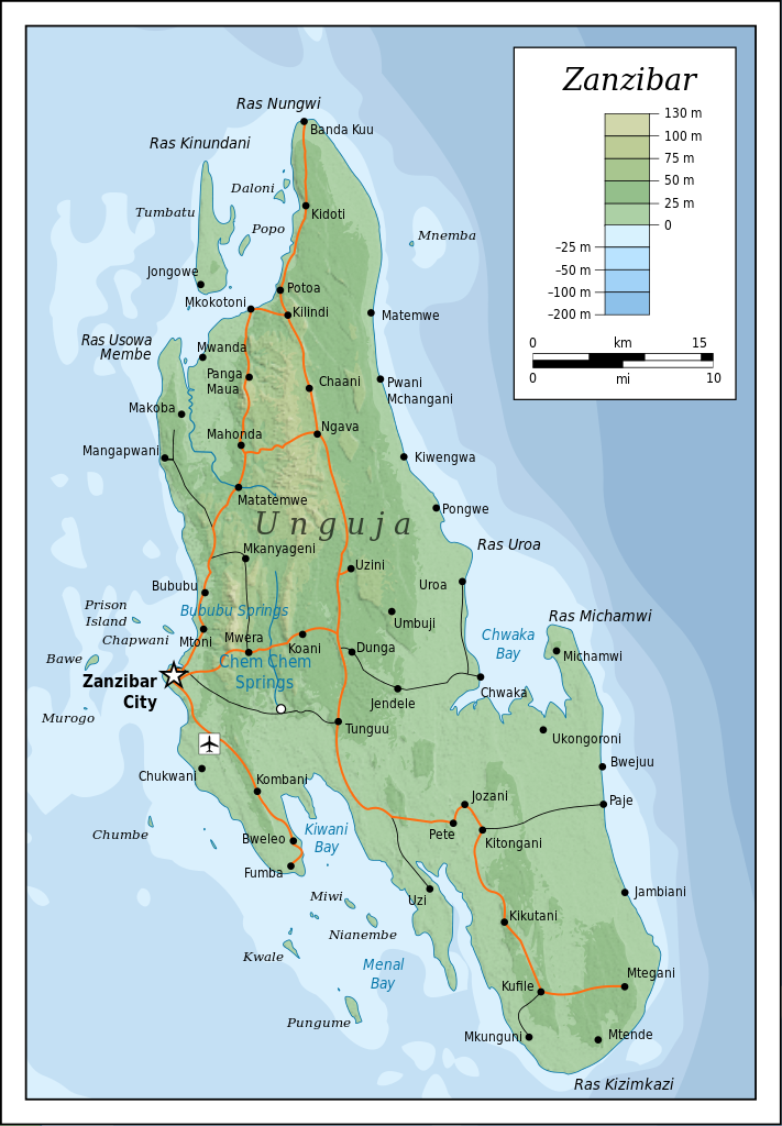
Self-made in Inkscape (renamed from Image:Topographic map of Zanzibar.svg). Roads, rivers and place names based on a public domain 1976 CIA map (from http://www.lib.utexas.edu/maps/tanzania.html) with some updates applied. Topography based on public domain SRTM data from NASA. Bathymetry per http://www.theissresearch.org/zanzibar/. |
| Tagsulat | Mysid |
| Other versions |
[]
|


|
This SVG file contains embedded text that can be translated into your language, using any capable SVG editor, text editor or the SVG Translate tool. For more information see: About translating SVG files. |
Pagtugot
I, the copyright holder of this work, hereby publish it under the following licenses:

|
Gitugot ang pagkopya, pag-apud-apod o/ug pag-usab ning maong dokumento ubos sa mga termino sa GNU Free Documentation License, Version 1.2 o mas bag-ong bersiyon nga gimantala sa Free Software Foundation; nga walay Invariant Sections, walay Front-Cover Texts, ug walay Back-Cover Texts. Ang kopya sa lisensiya gilakip sa bahin nga giulohang GNU Free Documentation License. |
This file is licensed under the Creative Commons Attribution-Share Alike 4.0 International, 3.0 Unported, 2.5 Generic, 2.0 Generic and 1.0 Generic license.
- Libre ka:
- sa pagsabwag – sa pagkopya, pag-apod-apod ug pagsabwag sa hinimo
- sa pag-remix – sa pag-adap sa binuhat
- Ubos sa mosunod nga mga kondisyon:
- atribusyon – Kinahanglan nimo nga hatagan ang angay nga kredito, maghatag usa ka link sa lisensya, ug ipakita kung adunay mga pagbag-o. Mahimo nimo kini buhaton sa bisan unsang makatarunganon nga paagi, apan dili sa bisan unsang paagi nga nagsugyot nga gi-endorso ka sa licensor o ang imong paggamit.
- share parehas – Kung imong gi-remix, gibag-o, o gibase sa materyal, kinahanglan nimo nga iapod-apod ang imong mga kontribusyon sa ilawom sa parehas o katugma nga lisensya sama sa orihinal.
You may select the license of your choice.
Kaagi sa payl
I-klik ang petsa/oras aron makit-an ang hulagway sa payl niadtong panahona.
| Petsa/Takna | Thumbnail | Mga dimensyon | Tiggamit | Komento | |
|---|---|---|---|---|---|
| kasamtangan | 20:52, 20 Hulyo 2010 | | 420 × 605 (409 KB) | Mysid | cropping fail! |
| 20:50, 20 Hulyo 2010 |  | 429 × 630 (409 KB) | Mysid | revised with relief shading and higher-grain topography | |
| 11:01, 19 Abril 2008 |  | 400 × 601 (61 KB) | Bibi Saint-Pol | {{inkscape}} == {{int:filedesc}} == {{Information |Description= {{en|Topographic map of Zanzibar, Tanzania.}} {{fi|Sansibarin (Tansania) topografinen kartta.}} |Source=Self-made in Inkscape.<br/>Boundaries based on a public domain 1976 CIA map (from http: |
Mga paggamit sa payl
Ang mosunod nga 2 panid misumpay niining payl:
Global nga paggamit sa payl
Kining ubang wiki naggamit ning maong payl:
- Paggamit sa af.wikipedia.org
- Paggamit sa ar.wikipedia.org
- Paggamit sa bg.wikipedia.org
- Paggamit sa ca.wikipedia.org
- Paggamit sa cs.wikipedia.org
- Paggamit sa cy.wikipedia.org
- Paggamit sa da.wikipedia.org
- Paggamit sa de.wikipedia.org
- Paggamit sa de.wikivoyage.org
- Paggamit sa el.wikipedia.org
- Paggamit sa en.wikipedia.org
- Paggamit sa eo.wikipedia.org
- Paggamit sa es.wikipedia.org
- Paggamit sa eu.wikipedia.org
- Paggamit sa fr.wikipedia.org
- Paggamit sa fy.wikipedia.org
- Paggamit sa gl.wikipedia.org
- Paggamit sa he.wikipedia.org
- Paggamit sa hr.wikipedia.org
- Paggamit sa hy.wikipedia.org
- Paggamit sa id.wikipedia.org
- Paggamit sa it.wikivoyage.org
- Paggamit sa ko.wikipedia.org
- Paggamit sa lt.wikipedia.org
- Paggamit sa mrj.wikipedia.org
- Paggamit sa nl.wikipedia.org
- Paggamit sa no.wikipedia.org
- Paggamit sa pl.wikipedia.org
- Paggamit sa pl.wiktionary.org
- Paggamit sa ru.wikipedia.org
- Paggamit sa sh.wikipedia.org
- Paggamit sa sn.wikipedia.org
- Paggamit sa sq.wikipedia.org
- Paggamit sa sv.wikipedia.org
- Paggamit sa uk.wikipedia.org
- Paggamit sa ur.wikipedia.org
- Paggamit sa vi.wikipedia.org
View more global usage of this file.