
Payl:Town of Primorsko aerial Boby Dimitrov.jpg

Gidak-on ning maong paunang tan-aw: 800 x 508 ka mga piksel. Uban pang mga resoluyon: 320 x 203 ka mga piksel | 640 x 406 ka mga piksel | 1,024 x 650 ka mga piksel | 1,543 x 980 ka mga piksel.
Tibuok resolusyon (1,543 × 980 pixels, size sa payl: 662 KB, MIME type: image/jpeg)
Mubong sugid:
| Deskripsyon |
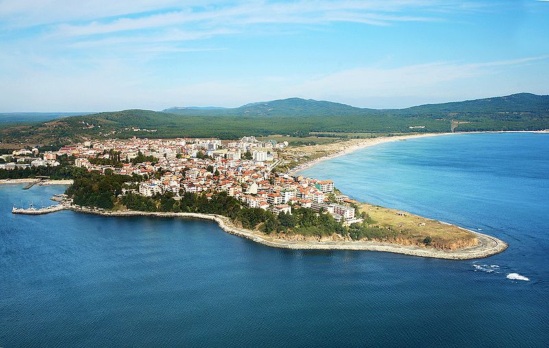
The main part of the town in foreground, far to the right is the north beach of Primorsko, far to the left - the beginning of the south beach. Shot from a small plane. |
| Petsa | |
| Gigikanan | Town of Primorsko |
| Tagsulat | Boby Dimitrov from Sofia, Bulgaria |
| Camera location | | View this and other nearby images on: OpenStreetMap |
|---|
Pagtugot
This file is licensed under the Creative Commons Attribution-Share Alike 2.0 Generic license.
- Libre ka:
- sa pagsabwag – sa pagkopya, pag-apod-apod ug pagsabwag sa hinimo
- sa pag-remix – sa pag-adap sa binuhat
- Ubos sa mosunod nga mga kondisyon:
- atribusyon – Kinahanglan nimo nga hatagan ang angay nga kredito, maghatag usa ka link sa lisensya, ug ipakita kung adunay mga pagbag-o. Mahimo nimo kini buhaton sa bisan unsang makatarunganon nga paagi, apan dili sa bisan unsang paagi nga nagsugyot nga gi-endorso ka sa licensor o ang imong paggamit.
- share parehas – Kung imong gi-remix, gibag-o, o gibase sa materyal, kinahanglan nimo nga iapod-apod ang imong mga kontribusyon sa ilawom sa parehas o katugma nga lisensya sama sa orihinal.
| This image was originally posted to Flickr by Boby Dimitrov at https://www.flickr.com/photos/63465428@N00/3767991103. It was reviewed on 31 Hulyo 2009 by FlickreviewR and was confirmed to be licensed under the terms of the cc-by-sa-2.0. |
Kaagi sa payl
I-klik ang petsa/oras aron makit-an ang hulagway sa payl niadtong panahona.
| Petsa/Takna | Thumbnail | Mga dimensyon | Tiggamit | Komento | |
|---|---|---|---|---|---|
| kasamtangan | 09:44, 31 Hulyo 2009 | | 1,543 × 980 (662 KB) | TodorBozhinov | {{Information |Description= The main part of the town in foreground, far to the right is the north beach of Primorsko, far to the left - the beginning of the south beach. Shot from a small plane. |Source=[http://www.flickr.com/photos/63465428@N00/3767991 |
Mga paggamit sa payl
Ang mosunod nga mga panid misumpay niining payl:
Global nga paggamit sa payl
Kining ubang wiki naggamit ning maong payl:
- Paggamit sa ar.wikipedia.org
- Paggamit sa azb.wikipedia.org
- Paggamit sa az.wikipedia.org
- Paggamit sa be.wikipedia.org
- Paggamit sa bg.wikipedia.org
- Paggamit sa ca.wikipedia.org
- Paggamit sa ckb.wikipedia.org
- Paggamit sa cs.wikipedia.org
- Paggamit sa de.wikivoyage.org
- Paggamit sa el.wikipedia.org
- Paggamit sa el.wikivoyage.org
- Paggamit sa en.wikipedia.org
- Paggamit sa en.wikivoyage.org
- Paggamit sa eo.wikipedia.org
- Paggamit sa es.wikipedia.org
- Paggamit sa fa.wikipedia.org
- Paggamit sa fr.wikipedia.org
- Paggamit sa he.wikipedia.org
- Paggamit sa he.wikivoyage.org
- Paggamit sa hy.wikipedia.org
- Paggamit sa it.wikipedia.org
- Paggamit sa ja.wikipedia.org
- Paggamit sa ka.wikipedia.org
- Paggamit sa nl.wikipedia.org
- Paggamit sa nn.wikipedia.org
- Paggamit sa no.wikipedia.org
- Paggamit sa os.wikipedia.org
- Paggamit sa pl.wikipedia.org
- Paggamit sa pt.wikipedia.org
- Paggamit sa ro.wikipedia.org
- Paggamit sa ru.wikipedia.org
- Paggamit sa simple.wikipedia.org
- Paggamit sa sk.wikipedia.org
- Paggamit sa sl.wikipedia.org
- Paggamit sa sr.wikipedia.org
- Paggamit sa sv.wikipedia.org
View more global usage of this file.