
Payl:Extensió del valencià al País Valencià.svg

Size of this PNG preview of this SVG file: 424 x 600 ka mga piksel. Uban pang mga resoluyon: 170 x 240 ka mga piksel | 339 x 480 ka mga piksel | 543 x 768 ka mga piksel | 724 x 1,024 ka mga piksel | 1,448 x 2,048 ka mga piksel | 744 x 1,052 ka mga piksel.
Tibuok resolusyon (SVG nga payl, nominally 744 × 1,052 pixels, size sa payl: 962 KB)
Mubong sugid:
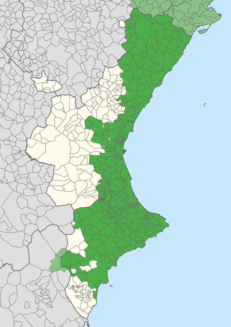
| Description |
English: Extension of the Valencian language in the Valencian Community, according to Casanova and Sanchis Guarner.
Español: Extensión del Valenciano en la Comunidad Valenciana. |
| Map legend |
Català:
Zones valencianoparlants a la Comunitat Valenciana. Zones valencianoparlants fora de la Comunitat Valenciana. Zones castellanoparlants a la Comunitat Valenciana que eren valencianoparlants el principi del s. XX. English:
Valencian-speaking regions in the Valencian Community. Valencian-speaking regions outside the Valencian Community. Spanish-speaking regions in the Valencian Community that were Valencian-speaking at the beginning of the 20th century. Español: Zonas Valencianoparlantes en la Comunidad Valenciana. Zones Valencianoparlantes fuera de la Comunidad Valenciana. Zonas Castellanoparlantes en la Comunidad Valenciana que eran Valencianoparlantes al principio del siglo XX. |
| Petsa | |
| Gigikanan | Carche.map and OpenStreetMap. |
| Creator | |
| Geotemporal data | |
| Scale | 1:1,500,000 |
| Heading |
 |
| Georeferencing | If inappropriate please set warp_status = skip to hide. |
| Other versions |
Derivative works of this file: |
| SVG genesis | |
Pagtugot
| This work contains information from OpenStreetMap, which is made available under the Open Database License (ODbL).
The ODbL does not require any particular license for maps produced from ODbL data. Prior to 1 August 2020, map tiles produced by the OpenStreetMap Foundation were licensed under the CC-BY-SA-2.0 license. Maps produced by other people may be subject to other licences. |
This file is licensed under the Creative Commons Attribution-Share Alike 2.5 Generic license.
Attribution: Joan M. Borràs (ebrenc)
- Libre ka:
- sa pagsabwag – sa pagkopya, pag-apod-apod ug pagsabwag sa hinimo
- sa pag-remix – sa pag-adap sa binuhat
- Ubos sa mosunod nga mga kondisyon:
- atribusyon – Kinahanglan nimo nga hatagan ang angay nga kredito, maghatag usa ka link sa lisensya, ug ipakita kung adunay mga pagbag-o. Mahimo nimo kini buhaton sa bisan unsang makatarunganon nga paagi, apan dili sa bisan unsang paagi nga nagsugyot nga gi-endorso ka sa licensor o ang imong paggamit.
- share parehas – Kung imong gi-remix, gibag-o, o gibase sa materyal, kinahanglan nimo nga iapod-apod ang imong mga kontribusyon sa ilawom sa parehas o katugma nga lisensya sama sa orihinal.
Kaagi sa payl
I-klik ang petsa/oras aron makit-an ang hulagway sa payl niadtong panahona.
| Petsa/Takna | Thumbnail | Mga dimensyon | Tiggamit | Komento | |
|---|---|---|---|---|---|
| kasamtangan | 11:27, 21 Abril 2020 | | 744 × 1,052 (962 KB) | FogueraC | voltants |
| 16:24, 20 Abril 2020 |  | 744 × 1,052 (881 KB) | FogueraC | standard colors | |
| 01:12, 18 Mayo 2007 |  | 725 × 1,244 (1.53 MB) | Ebrenc | {{Cc-by-sa-2.5|Joan M. Borràs (ebrenc)}} Category:Maps of the Land of Valencia Category:Catalan language |
Mga paggamit sa payl
There are no pages that use this file.
Global nga paggamit sa payl
Kining ubang wiki naggamit ning maong payl:
- Paggamit sa ar.wikipedia.org
- Paggamit sa ast.wikipedia.org
- Paggamit sa ca.wikipedia.org
- Paggamit sa co.wikipedia.org
- Paggamit sa cs.wikipedia.org
- Paggamit sa de.wikipedia.org
- Paggamit sa en.wikipedia.org
- Paggamit sa es.wikipedia.org
- Comunidad Valenciana
- Discusión:Idiomas de España
- Vega Baja del Segura
- Predominio lingüístico
- Ley de uso y enseñanza del valenciano
- Portal:Comunidad Valenciana
- Idioma valenciano
- Usuario:Castellónenred/Página de Pruebas/PortalCV/Cultura y Tradiciones
- Portal:Comunidad Valenciana/Cultura y Tradiciones
- Cultura de la Comunidad Valenciana
- Usuario:MetroVal/Valenciano
- Usuario:JuananMJ/Taller
- Paggamit sa es.wikivoyage.org
- Paggamit sa eu.wikipedia.org
- Paggamit sa ext.wikipedia.org
- Paggamit sa fi.wikipedia.org
- Paggamit sa fr.wikipedia.org
- Paggamit sa gl.wikipedia.org
- Paggamit sa he.wikipedia.org
- Paggamit sa ia.wikipedia.org
- Paggamit sa id.wikipedia.org
- Paggamit sa ie.wikipedia.org
- Paggamit sa it.wikipedia.org
- Paggamit sa ja.wikipedia.org
View more global usage of this file.