
Payl:Achaemenid Empire 500 BC.png

Gidak-on ning maong paunang tan-aw: 800 x 427 ka mga piksel. Uban pang mga resoluyon: 320 x 171 ka mga piksel | 640 x 341 ka mga piksel | 1,024 x 546 ka mga piksel | 1,280 x 683 ka mga piksel | 3,070 x 1,637 ka mga piksel.
Tibuok resolusyon (3,070 × 1,637 pixels, size sa payl: 811 KB, MIME type: image/png)
Mubong sugid:
| Deskripsyon |
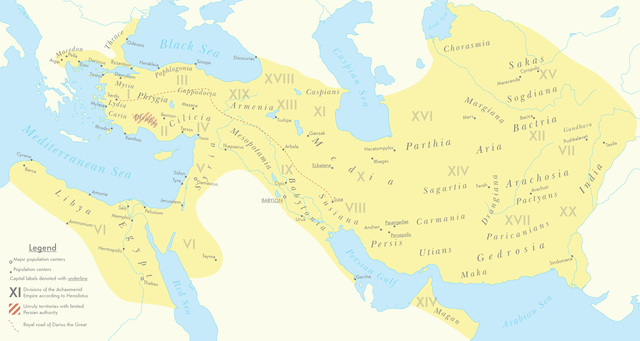
English: A map of the Achaemenid Empire around 500 BC featuring ancient regions, settlements and Satrapies. This map assembles information from the Historischer Schul-Atlas zur alten, mittleren und neueren Geschichte by Heinrich Kiepert and Carl Wolff from 1879 as accessed from GEI Digital, the 1923 edition of Historical Atlas by William R. Shepherd as accessed from the Perry-Castañeda Library's online map collection and Livius.org's article on the Satrapies of the Achaemenid Empire according to Herodotus. |
| Petsa | |
| Gigikanan | Kaugalingong trabaho |
| Tagsulat | Cattette |
Pagtugot
I, the copyright holder of this work, hereby publish it under the following license:
This file is licensed under the Creative Commons Attribution 4.0 International license.
- Libre ka:
- sa pagsabwag – sa pagkopya, pag-apod-apod ug pagsabwag sa hinimo
- sa pag-remix – sa pag-adap sa binuhat
- Ubos sa mosunod nga mga kondisyon:
- atribusyon – Kinahanglan nimo nga hatagan ang angay nga kredito, maghatag usa ka link sa lisensya, ug ipakita kung adunay mga pagbag-o. Mahimo nimo kini buhaton sa bisan unsang makatarunganon nga paagi, apan dili sa bisan unsang paagi nga nagsugyot nga gi-endorso ka sa licensor o ang imong paggamit.
Kaagi sa payl
I-klik ang petsa/oras aron makit-an ang hulagway sa payl niadtong panahona.
| Petsa/Takna | Thumbnail | Mga dimensyon | Tiggamit | Komento | |
|---|---|---|---|---|---|
| kasamtangan | 07:01, 12 Marso 2021 | | 3,070 × 1,637 (811 KB) | Cattette | Changed terminology, added Cyropolis |
| 06:05, 9 Marso 2021 |  | 3,070 × 1,637 (811 KB) | Cattette | Added more cities | |
| 21:52, 8 Marso 2021 |  | 3,070 × 1,637 (807 KB) | Cattette | Removed anachronistic labels, removed Thrace and Macedonia as Satrapies | |
| 20:44, 8 Marso 2021 |  | 3,070 × 1,637 (813 KB) | Cattette | Fixed north eastern border, tweaked satrapies | |
| 18:55, 8 Marso 2021 |  | 3,070 × 1,637 (794 KB) | Cattette | Tweaked borders and satraps | |
| 15:20, 8 Marso 2021 |  | 3,070 × 1,637 (789 KB) | Cattette | Fixed Indian border again, added cities in Greece | |
| 07:02, 8 Marso 2021 |  | 3,070 × 1,637 (785 KB) | Cattette | Stronger color, capitals, more cities, added Indian territories beyond the Indus | |
| 14:26, 7 Marso 2021 |  | 2,923 × 1,637 (729 KB) | Cattette | Uploaded own work with UploadWizard |
Mga paggamit sa payl
Ang mosunod nga 2 panid misumpay niining payl:
Global nga paggamit sa payl
Kining ubang wiki naggamit ning maong payl:
- Paggamit sa arz.wikipedia.org
- Paggamit sa ast.wikipedia.org
- Paggamit sa cs.wikipedia.org
- Paggamit sa en.wikipedia.org
- Paggamit sa fa.wikipedia.org
- Paggamit sa ga.wikipedia.org
- Paggamit sa gl.wikipedia.org
- Paggamit sa ha.wikipedia.org
- Paggamit sa he.wikipedia.org
- Paggamit sa ko.wikipedia.org
- Paggamit sa ku.wikipedia.org
- Paggamit sa pl.wikipedia.org
- Paggamit sa tg.wikipedia.org
- Paggamit sa www.wikidata.org