
Payl:Burnham, St Peter's Church - geograph.org.uk - 1118895.jpg
Walay mas taas nga resolusyon.
Burnham,_St_Peter's_Church_-_geograph.org.uk_-_1118895.jpg (640 × 480 pixels, size sa payl: 69 KB, MIME type: image/jpeg)
Mubong sugid:
| Deskripsyon |
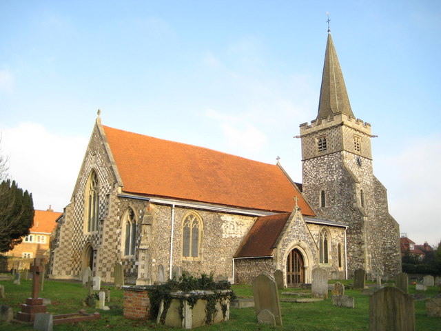
English: Church of England parish church of Saint Peter, Burnham, Buckinghamshire: view from the southwest. The tower was built in the 13th century, but its top was rebuilt in 1864 |
| Petsa | |
| Gigikanan | From geograph.org.uk |
| Tagsulat | Nigel Cox |
| Attribution (required by the license) | Nigel Cox / Burnham: St Peter's Church / |
| Camera location | | View this and other nearby images on: OpenStreetMap |
|---|
_heading:45.00&language=ceb)
| Object location | | View this and other nearby images on: OpenStreetMap |
|---|
_heading:45.00&language=ceb)
Pagtugot

|
This image was taken from the Geograph project collection. See this photograph's page on the Geograph website for the photographer's contact details. The copyright on this image is owned by Nigel Cox and is licensed for reuse under the Creative Commons Attribution-ShareAlike 2.0 license.
|
This file is licensed under the Creative Commons Attribution-Share Alike 2.0 Generic license.
Attribution: Nigel Cox
- Libre ka:
- sa pagsabwag – sa pagkopya, pag-apod-apod ug pagsabwag sa hinimo
- sa pag-remix – sa pag-adap sa binuhat
- Ubos sa mosunod nga mga kondisyon:
- atribusyon – Kinahanglan nimo nga hatagan ang angay nga kredito, maghatag usa ka link sa lisensya, ug ipakita kung adunay mga pagbag-o. Mahimo nimo kini buhaton sa bisan unsang makatarunganon nga paagi, apan dili sa bisan unsang paagi nga nagsugyot nga gi-endorso ka sa licensor o ang imong paggamit.
- share parehas – Kung imong gi-remix, gibag-o, o gibase sa materyal, kinahanglan nimo nga iapod-apod ang imong mga kontribusyon sa ilawom sa parehas o katugma nga lisensya sama sa orihinal.
Kaagi sa payl
I-klik ang petsa/oras aron makit-an ang hulagway sa payl niadtong panahona.
| Petsa/Takna | Thumbnail | Mga dimensyon | Tiggamit | Komento | |
|---|---|---|---|---|---|
| kasamtangan | 20:40, 24 Pebrero 2011 | | 640 × 480 (69 KB) | GeographBot | == {{int:filedesc}} == {{Information |description={{en|1=Burnham: St Peter's Church The church with its distinctive chequer-patterned west end dates in parts from the 12th century. Its website is here http://www.stpetersburnham.org/}} |date=2009-01-09 |so |
Mga paggamit sa payl
Ang mosunod nga mga panid misumpay niining payl:
Global nga paggamit sa payl
Kining ubang wiki naggamit ning maong payl:
- Paggamit sa ar.wikipedia.org
- Paggamit sa arz.wikipedia.org
- Paggamit sa cy.wikipedia.org
- Paggamit sa de.wikipedia.org
- Paggamit sa en.wikipedia.org
- Paggamit sa fa.wikipedia.org
- Paggamit sa fr.wikipedia.org
- Paggamit sa it.wikipedia.org
- Paggamit sa lld.wikipedia.org
- Paggamit sa pt.wikipedia.org
- Paggamit sa sv.wikipedia.org
- Paggamit sa www.wikidata.org
- Paggamit sa zh-min-nan.wikipedia.org