
Payl:Cani Islands Aerial-Cropted.jpg

Gidak-on ning maong paunang tan-aw: 800 x 531 ka mga piksel. Uban pang mga resoluyon: 320 x 213 ka mga piksel | 640 x 425 ka mga piksel | 1,024 x 680 ka mga piksel | 1,280 x 850 ka mga piksel | 2,560 x 1,700 ka mga piksel | 4,288 x 2,848 ka mga piksel.
Tibuok resolusyon (4,288 × 2,848 pixels, size sa payl: 6.48 MB, MIME type: image/jpeg)
| Deskripsyon |
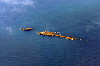
Deutsch: Luftaufnahme der Cani-Inseln (Tunesien) im Mittelmeer English: Aerial view of Cani Islands (Tunisia) in the Mediterranean Français : Les Îles Cani au large de Cap Zebib, nord-est Tunisie |
| Petsa | (UTC) |
| Gigikanan | |
| Tagsulat |
|
| This is a retouched picture, which means that it has been digitally altered from its original version. Modifications: Cropted and contrast. The original can be viewed here: Cani Islands Aerial.jpg:
|
I, the copyright holder of this work, hereby publish it under the following license:
This file is licensed under the Creative Commons Attribution-Share Alike 2.0 Generic license.
- Libre ka:
- sa pagsabwag – sa pagkopya, pag-apod-apod ug pagsabwag sa hinimo
- sa pag-remix – sa pag-adap sa binuhat
- Ubos sa mosunod nga mga kondisyon:
- atribusyon – Kinahanglan nimo nga hatagan ang angay nga kredito, maghatag usa ka link sa lisensya, ug ipakita kung adunay mga pagbag-o. Mahimo nimo kini buhaton sa bisan unsang makatarunganon nga paagi, apan dili sa bisan unsang paagi nga nagsugyot nga gi-endorso ka sa licensor o ang imong paggamit.
- share parehas – Kung imong gi-remix, gibag-o, o gibase sa materyal, kinahanglan nimo nga iapod-apod ang imong mga kontribusyon sa ilawom sa parehas o katugma nga lisensya sama sa orihinal.
Original upload log
This image is a derivative work of the following images:
- File:Cani_Islands_Aerial.jpg licensed with Cc-by-sa-2.0
- 2009-05-19T12:16:18Z FlickreviewR 4288x2848 (6145915 Bytes) Replacing image by its original image from Flickr
- 2009-05-19T10:53:52Z Telim tor 1024x680 (394607 Bytes) == Beschreibung == {{Information |Description= {{de|Luftaufnahme der Cani-Inseln (Tuinesien) im Mittelmeer}} {{en|Aerial view of cani Islands (Tunusia) in the Mediterranean}} |Source=[http://www.flickr.com/photos/t_abdelmoume
Uploaded with derivativeFX
Kaagi sa payl
I-klik ang petsa/oras aron makit-an ang hulagway sa payl niadtong panahona.
| Petsa/Takna | Thumbnail | Mga dimensyon | Tiggamit | Komento | |
|---|---|---|---|---|---|
| kasamtangan | 00:38, 25 Enero 2013 | | 4,288 × 2,848 (6.48 MB) | Slick-o-bot | Bot: convert to a non-interlaced jpeg (see bug #17645) |
| 18:31, 28 Septiyembre 2009 |  | 4,288 × 2,848 (6.01 MB) | M0tty | {{Information |Description={{de|Luftaufnahme der Cani-Inseln (Tunesien) im Mittelmeer}} {{en|Aerial view of Cani Islands (Tunisia) in the Mediterranean}} {{fr|Les Îles Cani au large de Cap Zebib, nord-est Tunisie}} |Source=*[[:File:Cani_Islands_Aerial.jp |
Mga paggamit sa payl
Ang mosunod nga mga panid misumpay niining payl:
Global nga paggamit sa payl
Kining ubang wiki naggamit ning maong payl:
- Paggamit sa ar.wikipedia.org
- Paggamit sa ca.wikipedia.org
- Paggamit sa cy.wikipedia.org
- Paggamit sa de.wikipedia.org
- Paggamit sa es.wikipedia.org
- Paggamit sa fr.wikipedia.org
- Paggamit sa it.wikipedia.org
- Paggamit sa sv.wikipedia.org
- Paggamit sa www.wikidata.org