
Payl:Cayman Islands location map.svg

Size of this PNG preview of this SVG file: 799 x 319 ka mga piksel. Uban pang mga resoluyon: 320 x 128 ka mga piksel | 640 x 256 ka mga piksel | 1,024 x 409 ka mga piksel | 1,280 x 511 ka mga piksel | 2,560 x 1,022 ka mga piksel | 924 x 369 ka mga piksel.
Tibuok resolusyon (SVG nga payl, nominally 924 × 369 pixels, size sa payl: 33 KB)
| Deskripsyon |
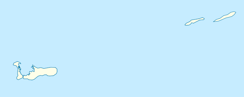
Deutsch: Positionskarte der Kaimaninseln. Geographische Begrenzungen der Karte:
English: Location map of the Cayman Islands. Geographic limits of the map:
|
| Petsa | |
| Gigikanan | Kaugalingong trabaho, using OpenStreetMap Data for the coastlines |
| Tagsulat |
Graphic made by Carport |
Pagtugot
This file is licensed under the Creative Commons Attribution-Share Alike 2.0 Generic license.
- Libre ka:
- sa pagsabwag – sa pagkopya, pag-apod-apod ug pagsabwag sa hinimo
- sa pag-remix – sa pag-adap sa binuhat
- Ubos sa mosunod nga mga kondisyon:
- atribusyon – Kinahanglan nimo nga hatagan ang angay nga kredito, maghatag usa ka link sa lisensya, ug ipakita kung adunay mga pagbag-o. Mahimo nimo kini buhaton sa bisan unsang makatarunganon nga paagi, apan dili sa bisan unsang paagi nga nagsugyot nga gi-endorso ka sa licensor o ang imong paggamit.
- share parehas – Kung imong gi-remix, gibag-o, o gibase sa materyal, kinahanglan nimo nga iapod-apod ang imong mga kontribusyon sa ilawom sa parehas o katugma nga lisensya sama sa orihinal.
Kaagi sa payl
I-klik ang petsa/oras aron makit-an ang hulagway sa payl niadtong panahona.
| Petsa/Takna | Thumbnail | Mga dimensyon | Tiggamit | Komento | |
|---|---|---|---|---|---|
| kasamtangan | 17:07, 23 Nobiyembre 2009 | 924 × 369 (33 KB) | Carport | {{Information |Description={{de|1=Positionskarte der {{w|Kaimaninseln|3=de}}. Geographische Begrenzungen der Karte: * N: 19.84° N * S: 19.14° N * W: 81.52° W * E: 79.66° W}} {{en|1=Location map of the {{w|Cayman Islands}}. Geographic limits of the ma |
Mga paggamit sa payl
More than 100 pages use this file. The following list shows the first 100 pages that use this file only. A full list is available.
- Anchor Point
- Bamboo Bay
- Beach Bay
- Beach Point
- Big Channel
- Bloody Bay
- Bluff Bay
- Boatswain Bay
- Boatswain Point
- Bodden
- Bodden Town
- Cat Head Bay
- Cayman Brac
- Cayman Islands (pagklaro)
- Cedar Point
- Channel Bay
- Charles Bay
- Charles Bight
- Colliers Bay
- Colliers Point
- Colliers Pond
- Conch Point
- Cottage Point
- Cotton Tree Bay
- Crawl Bay
- Deadmans Point
- Dennis Point
- Dolphin Point
- East Channel
- East End
- East Point
- Eden Rocks
- Fisherman Rock
- Fisherman’s Rock
- Flat Rocks
- Frenchman Point
- George Town
- Goat Bay
- Governors Creek
- Great Bluff
- Gun Bluff
- High Rock Point
- Jackson Point
- Jacksons Pond
- Juniper Bay
- Little Cayman
- Little Pedro Point
- Little Sound
- Long Point
- Low Point
- Lower Rocky Point
- Main Channel
- Moon Bay
- Moore Lake
- North Reef
- North Side
- Owen Island
- Palmetto Point
- Pease Bay
- Preston Bay
- Prospect Beach
- Prospect Point
- Rum Point
- Salt Water Pond
- Sand Bluff
- Sand Cay
- Sanders Rock
- Sandy Point
- Scotts Bay
- Sea Pond
- Seven Mile Beach
- Sister Island
- Snipe Point
- South Channel
- South Sound
- South West Point
- Southwest Point
- Spanish Bay
- Sparrowhawk Point
- Spot Bay
- Stake Bay
- Tarpon Lake
- The Bight
- The Channel
- The Narrows
- The Rock
- Water Cay
- Water Point
- Wearis Bay
- Welch Point
- Welch Point (punta sa Kapupud-ang Keyman)
- West Bay
- West Bay (kapital sa rehiyon)
- West Bay (luuk sa Kapupud-ang Keyman, lat 19,35, long -81,40)
- West End
- West End Point
- West End Point (punta sa Kapupud-ang Keyman, lat 19,66, long -80,12)
- West End Point (punta sa Kapupud-ang Keyman, lat 19,68, long -79,90)
- White Bay
- White Bay (luuk sa Kapupud-ang Keyman)
View more links to this file.
Global nga paggamit sa payl
Kining ubang wiki naggamit ning maong payl:
- Paggamit sa af.wikipedia.org
- Paggamit sa an.wikipedia.org
- Paggamit sa ar.wikipedia.org
- Paggamit sa ast.wikipedia.org
- Paggamit sa ba.wikipedia.org
- Paggamit sa be.wikipedia.org
- Paggamit sa bg.wikipedia.org
- Paggamit sa cs.wikipedia.org
- Paggamit sa da.wikipedia.org
- Paggamit sa de.wikipedia.org
- George Town (Cayman Islands)
- Grand Cayman
- Little Cayman
- Cayman Brac
- Wikipedia:Kartenwerkstatt/Positionskarten/Nordamerika
- Vorlage:Positionskarte Cayman Islands
- Benutzer:Carport/Galerie
- Wikipedia:Kartenwerkstatt/Archiv/2009-11
- Truman Bodden Sports Complex
- CONCACAF U-20-Meisterschaft der Frauen 2014
- Owen Island (Cayman Islands)
- Edward Bodden Airfield
- Paggamit sa de.wikivoyage.org
- Paggamit sa en.wikipedia.org
View more global usage of this file.