
Payl:Champlainmap fr.svg

Size of this PNG preview of this SVG file: 465 x 470 ka mga piksel. Uban pang mga resoluyon: 237 x 240 ka mga piksel | 475 x 480 ka mga piksel | 760 x 768 ka mga piksel | 1,013 x 1,024 ka mga piksel | 2,026 x 2,048 ka mga piksel.
Tibuok resolusyon (SVG nga payl, nominally 465 × 470 pixels, size sa payl: 99 KB)
Mubong sugid:
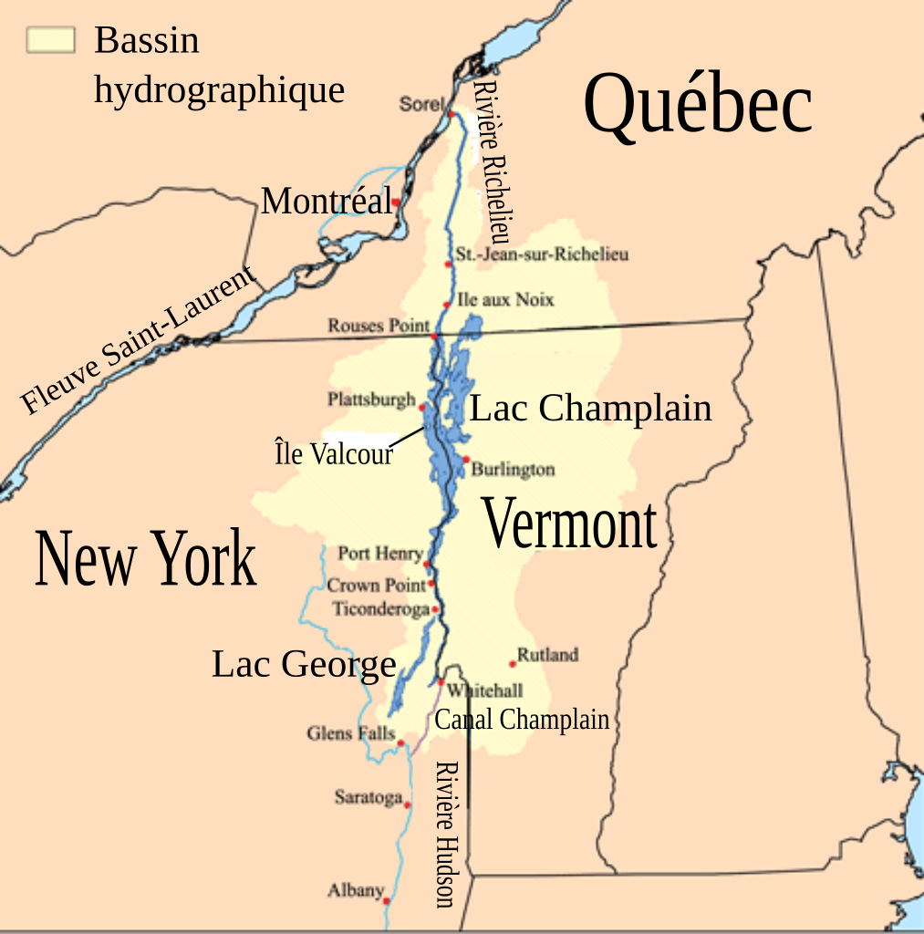
| Deskripsyon | Cette carte montre le bassin hydrographique du Lac Champlain et de la rivière Richelieu. L'auteur original a utilisé les données du USGS, Bureau du recensement des États-Unis et de Digital Chart of the World data. |
| Petsa | (UTC) |
| Gigikanan | Champlainmap.png |
| Tagsulat |
|
| SVG genesis |
| This is a retouched picture, which means that it has been digitally altered from its original version. The original can be viewed here: Champlainmap.png:
|
Pagtugot
I, the copyright holder of this work, hereby publish it under the following license:
This file is licensed under the Creative Commons Attribution-Share Alike 2.5 Generic license.
- Libre ka:
- sa pagsabwag – sa pagkopya, pag-apod-apod ug pagsabwag sa hinimo
- sa pag-remix – sa pag-adap sa binuhat
- Ubos sa mosunod nga mga kondisyon:
- atribusyon – Kinahanglan nimo nga hatagan ang angay nga kredito, maghatag usa ka link sa lisensya, ug ipakita kung adunay mga pagbag-o. Mahimo nimo kini buhaton sa bisan unsang makatarunganon nga paagi, apan dili sa bisan unsang paagi nga nagsugyot nga gi-endorso ka sa licensor o ang imong paggamit.
- share parehas – Kung imong gi-remix, gibag-o, o gibase sa materyal, kinahanglan nimo nga iapod-apod ang imong mga kontribusyon sa ilawom sa parehas o katugma nga lisensya sama sa orihinal.
Original upload log
This image is a derivative work of the following images:
- File:Champlainmap.png licensed with Cc-by-sa-2.5
- 2011-03-28T23:38:51Z Gilbertus 465x470 (36608 Bytes) retrait du cadre
- 2006-07-26T17:29:43Z Kmusser 500x500 (34969 Bytes)
- 2006-07-26T17:02:12Z Kmusser 500x500 (34791 Bytes) This is a map showing the [[:en:Lake Champlain|Lake Champlain]] - [[:en:Richelieu River|Richelieu River]] watershed. I made using [[:en:United States Geological Survey|USGS]], [[:en:United States Census Bureau|Census Bureau]
Uploaded with derivativeFX
Kaagi sa payl
I-klik ang petsa/oras aron makit-an ang hulagway sa payl niadtong panahona.
| Petsa/Takna | Thumbnail | Mga dimensyon | Tiggamit | Komento | |
|---|---|---|---|---|---|
| kasamtangan | 02:00, 26 Disyembre 2011 | | 465 × 470 (99 KB) | Pierre cb | == {{int:filedesc}} == {{Information |Description=Cette carte montre le bassin hydrographique du Lac Champlain et de la rivière Richelieu. L'auteur original a utilisé les données du [[:fr:United States |
Mga paggamit sa payl
Ang mosunod nga mga panid misumpay niining payl:
Global nga paggamit sa payl
Kining ubang wiki naggamit ning maong payl:
- Paggamit sa en.wikipedia.org
- Paggamit sa fr.wikipedia.org
- Paggamit sa la.wikipedia.org
- Paggamit sa pt.wikipedia.org
- Paggamit sa www.wikidata.org