Payl:China Fujian2 location map.svg

Page contents not supported in other languages.
Gikan sa Wikipedia, ang gawasnong ensiklopedya

Tibuok resolusyon(SVG nga payl, nominally 780 × 818 pixels, size sa payl: 277 KB)

Kining maong payl gikan sa Wikimedia Commons ug mahimong gigamit sa ubang proyekto. Ang deskripsyon niini didto gipakita sa ubos.

Mubong sugid:

Deskripsyon
Deutsch: Positionskarte von Fujian, Volksrepublik China

Quadratische Plattkarte, N-S-Streckung 111 %. Geographische Begrenzung der Karte:

  • N: 28.5° N
  • S: 23.3° N
  • W: 115.5° O
  • O: 121.0° O
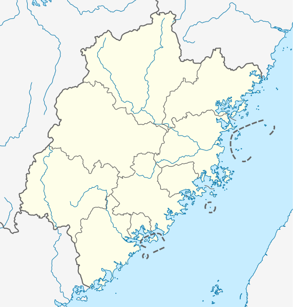
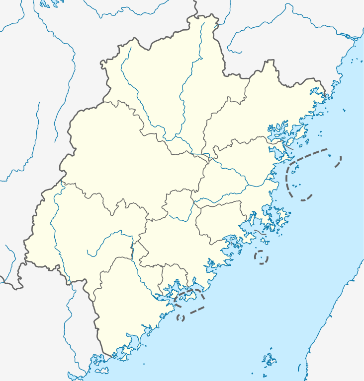
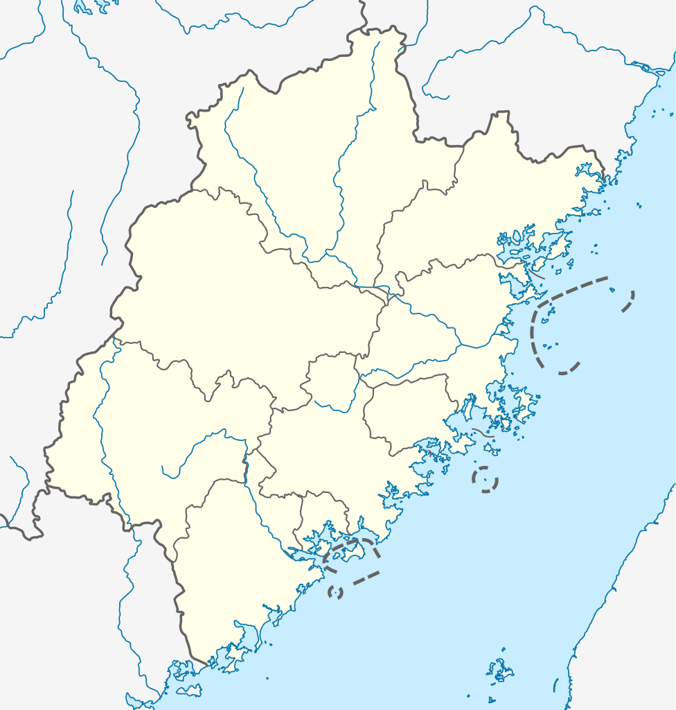
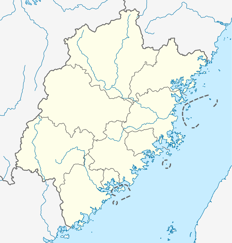
English: Location map of Fujian, People's Republic of China
(Note: the insular counties of Kinmen (Quemoy) and Lienchiang (Matsu Islands), Taiwan (ROC), are shown with dashed lines.)

Equirectangular projection, N/S stretching 111 %. Geographic limits of the map:

  • N: 28.5° N
  • S: 23.3° N
  • W: 115.5° E
  • E: 121.0° E
Petsa
Gigikanan

Kaugalingong trabaho, using

Tagsulat NordNordWest
Pagtugot
(Paggamit pag-usab niini nga file)

I have published this file as author NordNordWest under the "CC-BY-SA-3.0-DE" in Wikipedia. This means that free, commercial usage outside of Wikipedia is permitted under the following licence terms:

Please send me a specimen copy or the URL of the website where the file is used.

Please write an email to nnwest[at]web.de if you

  • need my postal address for sending a specimen copy
  • have further questions about the terms of the licence

PS: In case of refusal of the above terms the author reserves the right to take legal action.

w:en:Creative Commons
atribusyon share parehas
This file is licensed under the Creative Commons Attribution-Share Alike 3.0 Germany license.
Libre ka:
  • sa pagsabwag – sa pagkopya, pag-apod-apod ug pagsabwag sa hinimo
  • sa pag-remix – sa pag-adap sa binuhat
Ubos sa mosunod nga mga kondisyon:
  • atribusyon – Kinahanglan nimo nga hatagan ang angay nga kredito, maghatag usa ka link sa lisensya, ug ipakita kung adunay mga pagbag-o. Mahimo nimo kini buhaton sa bisan unsang makatarunganon nga paagi, apan dili sa bisan unsang paagi nga nagsugyot nga gi-endorso ka sa licensor o ang imong paggamit.
  • share parehas – Kung imong gi-remix, gibag-o, o gibase sa materyal, kinahanglan nimo nga iapod-apod ang imong mga kontribusyon sa ilawom sa parehas o katugma nga lisensya sama sa orihinal.
w:en:Creative Commons
atribusyon share parehas
This file is licensed under the Creative Commons Attribution-Share Alike 3.0 Unported license.
Libre ka:
  • sa pagsabwag – sa pagkopya, pag-apod-apod ug pagsabwag sa hinimo
  • sa pag-remix – sa pag-adap sa binuhat
Ubos sa mosunod nga mga kondisyon:
  • atribusyon – Kinahanglan nimo nga hatagan ang angay nga kredito, maghatag usa ka link sa lisensya, ug ipakita kung adunay mga pagbag-o. Mahimo nimo kini buhaton sa bisan unsang makatarunganon nga paagi, apan dili sa bisan unsang paagi nga nagsugyot nga gi-endorso ka sa licensor o ang imong paggamit.
  • share parehas – Kung imong gi-remix, gibag-o, o gibase sa materyal, kinahanglan nimo nga iapod-apod ang imong mga kontribusyon sa ilawom sa parehas o katugma nga lisensya sama sa orihinal.
Kartenwerkstatt
This map has been made or improved in the German Kartenwerkstatt (Map Lab). You can propose maps to improve as well.

Captions

Add a one-line explanation of what this file represents

Items portrayed in this file

depicts English

copyrighted English

20 Hunyo 2011

media type English

image/svg+xml

checksum English

e596af2b9c2a0648e2a815b92b71a7acc5beba40

determination method English: SHA-1 English

data size English

283,322 byte

height English

818 pixel

width English

780 pixel

Kaagi sa payl

I-klik ang petsa/oras aron makit-an ang hulagway sa payl niadtong panahona.

Petsa/TaknaThumbnailMga dimensyonTiggamitKomento
kasamtangan17:21, 14 Oktubre 2020Thumbnail sa bersyon sa 17:21, 14 Oktubre 2020780 × 818 (277 KB)NordNordWestupd
12:18, 20 Hunyo 2011Thumbnail sa bersyon sa 12:18, 20 Hunyo 2011780 × 818 (282 KB)NordNordWest=={{int:filedesc}}== {{Information |Description= {{de|Positionskarte von Fujian, Volksrepublik China}} Quadratische Plattkarte, N-S-Streckung 111 %. Geographische Begrenzung der Karte: * N: 28.5° N * S: 23.3° N

Ang mosunod nga mga panid misumpay niining payl:

Global nga paggamit sa payl

Metadata