
Payl:Cocos (Keeling) Islands location map.svg

Size of this PNG preview of this SVG file: 295 x 600 ka mga piksel. Uban pang mga resoluyon: 118 x 240 ka mga piksel | 236 x 480 ka mga piksel | 378 x 768 ka mga piksel | 504 x 1,024 ka mga piksel | 1,007 x 2,048 ka mga piksel | 772 x 1,569 ka mga piksel.
Tibuok resolusyon (SVG nga payl, nominally 772 × 1,569 pixels, size sa payl: 193 KB)
_Islands_location_map.svg)
Mubong sugid:
| Deskripsyon |
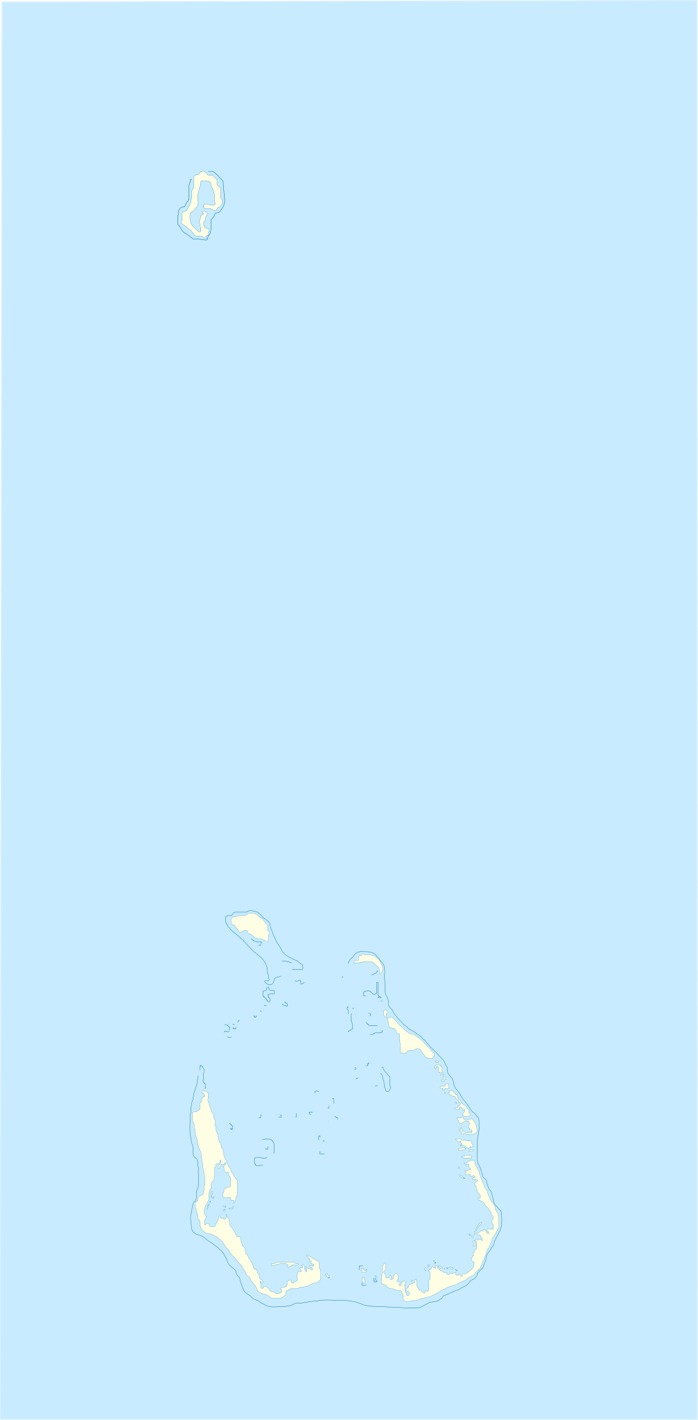
English: Location map of Cocos_(Keeling)_Islands
Equirectangular projection. Geographic limits of the map:
Français : Carte de localisation des Îles Cocos
projection equirectangulaire. Les limites géographiques sont
|
| Petsa | |
| Gigikanan | Kaugalingong trabaho |
| Tagsulat | Xfigpower |
la vectorisation à main levée s'est appuyé sur Image:Cocos(keeling)_76.jpg
_76.jpg)
Pagtugot
I, the copyright holder of this work, hereby publish it under the following licenses:

|
Gitugot ang pagkopya, pag-apud-apod o/ug pag-usab ning maong dokumento ubos sa mga termino sa GNU Free Documentation License, Version 1.2 o mas bag-ong bersiyon nga gimantala sa Free Software Foundation; nga walay Invariant Sections, walay Front-Cover Texts, ug walay Back-Cover Texts. Ang kopya sa lisensiya gilakip sa bahin nga giulohang GNU Free Documentation License. |
This file is licensed under the Creative Commons Attribution 3.0 Unported license.
- Libre ka:
- sa pagsabwag – sa pagkopya, pag-apod-apod ug pagsabwag sa hinimo
- sa pag-remix – sa pag-adap sa binuhat
- Ubos sa mosunod nga mga kondisyon:
- atribusyon – Kinahanglan nimo nga hatagan ang angay nga kredito, maghatag usa ka link sa lisensya, ug ipakita kung adunay mga pagbag-o. Mahimo nimo kini buhaton sa bisan unsang makatarunganon nga paagi, apan dili sa bisan unsang paagi nga nagsugyot nga gi-endorso ka sa licensor o ang imong paggamit.
You may select the license of your choice.
Kaagi sa payl
I-klik ang petsa/oras aron makit-an ang hulagway sa payl niadtong panahona.
| Petsa/Takna | Thumbnail | Mga dimensyon | Tiggamit | Komento | |
|---|---|---|---|---|---|
| kasamtangan | 10:17, 4 Agosto 2010 | | 772 × 1,569 (193 KB) | Xfigpower | {{Information |Description={{en|1=Location map of Cocos_(Keeling)_Islands}} Equirectangular projection. Geographic limits of the map: * N: 11°45' S * S: 12°15' S * W: 96°45' E * E: 97°00 E}} {{fr|1=Carte de lo |
Mga paggamit sa payl
Ang mosunod nga 85 panid misumpay niining payl:
- Alor Batu Kapala
- Alor Pinyu
- Bantam Village
- Bechat Besar
- Burial Island
- Burton Point
- Burton Point (punta sa Kapupud-ang Cocos)
- Cocos Island Airport
- Cocos Islands
- Cocos Islands (pagklaro)
- Direction Island
- Direction Island (pulo sa Kapupud-ang Cocos)
- Dymoke Shoal
- East Cay
- Gooseberry Island
- Home Island
- Home Island (pulo sa Kapupud-ang Cocos)
- Horsburgh Island
- Horsburgh Island (pulo sa Kapupud-ang Cocos)
- Keeling Islands
- Klapa Tuju
- North Keeling Island
- North Lagoon
- North Lagoon (lanaw sa Kapupud-ang Cocos, lat -12,17, long 96,83)
- Port Refuge
- Port Refuge (dunggoanan sa Kapupud-ang Cocos, lat -12,08, long 96,87)
- Port Refuge (dunggoanan sa Kapupud-ang Cocos, lat -12,10, long 96,87)
- Port Refuge (pundohanan)
- Possession Point
- Possession Point (punta sa Kapupud-ang Cocos)
- Prison Island
- Prison Island (pulo sa Kapupud-ang Cocos)
- Pulo Cheplok
- Pulo Gangsa
- Pulo Kambing
- Pulo Klapa Satu
- Pulo Maria
- Pulo Panjang
- Pulu Ampang
- Pulu Ampang Kechil
- Pulu Belan
- Pulu Belan (pulo, lat -12,20, long 96,88)
- Pulu Belan Madar
- Pulu Blekok
- Pulu Jembatan
- Pulu Kembang
- Pulu Labu
- Pulu Maria
- Pulu Pandan
- Pulu Pasir
- Pulu Siput
- Pulu Wa-idas
- Pulu Wak Banka
- Ross
- Ross Island
- Selma
- Selma Island
- South Island
- South Island (pulo sa Kapupud-ang Cocos)
- South Keeling Islands
- South Lagoon (lanaw sa Kapupud-ang Cocos)
- Tanjong Klikil
- Tanjong Pugi
- Telok Gerongjeng
- Telok Semberang
- Telok Semberang (luuk, lat -12,20, long 96,90)
- Teluk Jambu
- Trannies Beach
- Turk Reef
- Ujong Pulo Dekat
- Ujong Pulu Jau
- Ujong Tanjong
- Ujong Tanjong (punta sa Kapupud-ang Cocos)
- West Cay
- West Island
- West Island (pulo sa Kapupud-ang Cocos, lat -12,18, long 96,83)
- West Island (ulohang dakbayan)
- Western Entrance
- Western Entrance (agianan nga nabigasyon)
- Workhouse Island
- Wreck Point
- Wreck Point (punta sa Kapupud-ang Cocos)
- Gumagamit:Lsjbot/Duplicates/Cocos Islands
- Gumagamit:Lsjbot/Duplicates/Cocos Islands (kapuloan sa Cocos Islands, lat -12,00, long 96,83)
- Plantilya:Location map Cocos (Keeling) Islands
Global nga paggamit sa payl
Kining ubang wiki naggamit ning maong payl:
- Paggamit sa af.wikipedia.org
- Paggamit sa an.wikipedia.org
- Paggamit sa ar.wikipedia.org
- Paggamit sa ast.wikipedia.org
- Paggamit sa ba.wikipedia.org
- Paggamit sa bn.wikipedia.org
- Paggamit sa bs.wikipedia.org
- Paggamit sa ckb.wikipedia.org
- Paggamit sa cs.wikipedia.org
- Paggamit sa da.wikipedia.org
- Paggamit sa de.wikipedia.org
- Paggamit sa de.wikivoyage.org
- Paggamit sa el.wikipedia.org
- Paggamit sa en.wikipedia.org
- Paggamit sa eo.wikipedia.org
- Paggamit sa es.wikipedia.org
- Paggamit sa fa.wikipedia.org
- Paggamit sa frr.wikipedia.org
- Paggamit sa fr.wikipedia.org
View more global usage of this file.
_Islands_location_map.svg)
_Islands_location_map.svg)