
Payl:Corse region relief location map.jpg

Gidak-on ning maong paunang tan-aw: 304 x 600 ka mga piksel. Uban pang mga resoluyon: 121 x 240 ka mga piksel | 243 x 480 ka mga piksel | 824 x 1,625 ka mga piksel.
Tibuok resolusyon (824 × 1,625 pixels, size sa payl: 324 KB, MIME type: image/jpeg)
Mubong sugid:
| Camera location | | View this and other nearby images on: OpenStreetMap |
|---|
| Deskripsyon |
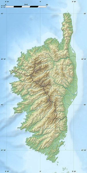
English: Blank physical map of the region of Corsica, France, for geo-location purpose, with distinct boundaries for departments and arrondissements as they are since January 2010.
The former version of the map shows the boundaries as they were until December 2009. Français : Carte physique vierge de la région Corse, France, destinée à la géolocalisation, avec limite distincte des départements et arrondissements tels que depuis janvier 2010. L'ancienne version de la carte montre le découpage administratif tel qu'il était jusqu'en décembre 2009. Scales: 1:520,000 (precision: 130 m) for the topography; 1:7,420,000 (precision: 1,855 m) for the bathymetry
Geographic limits of the map:
|
||
| Petsa | 2008-08, modified 02-2010 | ||
| Gigikanan |
Kaugalingong trabaho
|
||
| Tagsulat | Eric Gaba (Sting - fr:Sting) | ||
| Pagtugot (Paggamit pag-usab niini nga file) |
|
||
| Other versions |
|

Pagtugot
I, the copyright holder of this work, hereby publish it under the following licenses:
This file is licensed under the Creative Commons Attribution-Share Alike 3.0 Unported license.
- Libre ka:
- sa pagsabwag – sa pagkopya, pag-apod-apod ug pagsabwag sa hinimo
- sa pag-remix – sa pag-adap sa binuhat
- Ubos sa mosunod nga mga kondisyon:
- atribusyon – Kinahanglan nimo nga hatagan ang angay nga kredito, maghatag usa ka link sa lisensya, ug ipakita kung adunay mga pagbag-o. Mahimo nimo kini buhaton sa bisan unsang makatarunganon nga paagi, apan dili sa bisan unsang paagi nga nagsugyot nga gi-endorso ka sa licensor o ang imong paggamit.
- share parehas – Kung imong gi-remix, gibag-o, o gibase sa materyal, kinahanglan nimo nga iapod-apod ang imong mga kontribusyon sa ilawom sa parehas o katugma nga lisensya sama sa orihinal.

|
Gitugot ang pagkopya, pag-apud-apod o/ug pag-usab ning maong dokumento ubos sa mga termino sa GNU Free Documentation License, Version 1.2 o mas bag-ong bersiyon nga gimantala sa Free Software Foundation; nga walay Invariant Sections, walay Front-Cover Texts, ug walay Back-Cover Texts. Ang kopya sa lisensiya gilakip sa bahin nga giulohang GNU Free Documentation License. |
You may select the license of your choice.
Kaagi sa payl
I-klik ang petsa/oras aron makit-an ang hulagway sa payl niadtong panahona.
| Petsa/Takna | Thumbnail | Mga dimensyon | Tiggamit | Komento | |
|---|---|---|---|---|---|
| kasamtangan | 13:50, 18 Hulyo 2010 | | 824 × 1,625 (324 KB) | Sting | Color profile |
| 18:33, 22 Pebrero 2010 |  | 824 × 1,625 (317 KB) | Sting | Updated arrondissments boundaries of Haute-Corse | |
| 19:50, 14 Agosto 2008 |  | 824 × 1,625 (315 KB) | Sting | == Summary == {{Location|42|12|00|N|09|03|00|E|scale:2000000}} <br/> {{Information |Description={{en|Blank physical map of the region of Corsica, France, for geo-location purpose, with distinct boundaries for departments and arrondissement |
Mga paggamit sa payl
Ang mosunod nga 2 panid misumpay niining payl:
Global nga paggamit sa payl
Kining ubang wiki naggamit ning maong payl:
- Paggamit sa als.wikipedia.org
- Paggamit sa ang.wikipedia.org
- Paggamit sa ar.wikipedia.org
- Paggamit sa ast.wikipedia.org
- Paggamit sa bg.wikipedia.org
- Paggamit sa bn.wikipedia.org
- Paggamit sa bs.wikipedia.org
- Paggamit sa ca.wikipedia.org
- Paggamit sa cs.wikipedia.org
- Paggamit sa de.wikipedia.org
- Paggamit sa de.wikivoyage.org
- Paggamit sa dsb.wikipedia.org
- Paggamit sa el.wikipedia.org
- Paggamit sa en.wikipedia.org
View more global usage of this file.