
Payl:EU-Ireland.svg

Size of this PNG preview of this SVG file: 713 x 600 ka mga piksel. Uban pang mga resoluyon: 285 x 240 ka mga piksel | 571 x 480 ka mga piksel | 913 x 768 ka mga piksel | 1,218 x 1,024 ka mga piksel | 2,435 x 2,048 ka mga piksel | 2,045 x 1,720 ka mga piksel.
Tibuok resolusyon (SVG nga payl, nominally 2,045 × 1,720 pixels, size sa payl: 7.33 MB)
Mubong sugid:
| Deskripsyon |
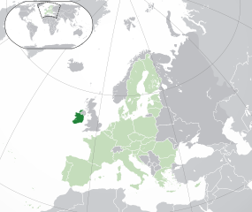
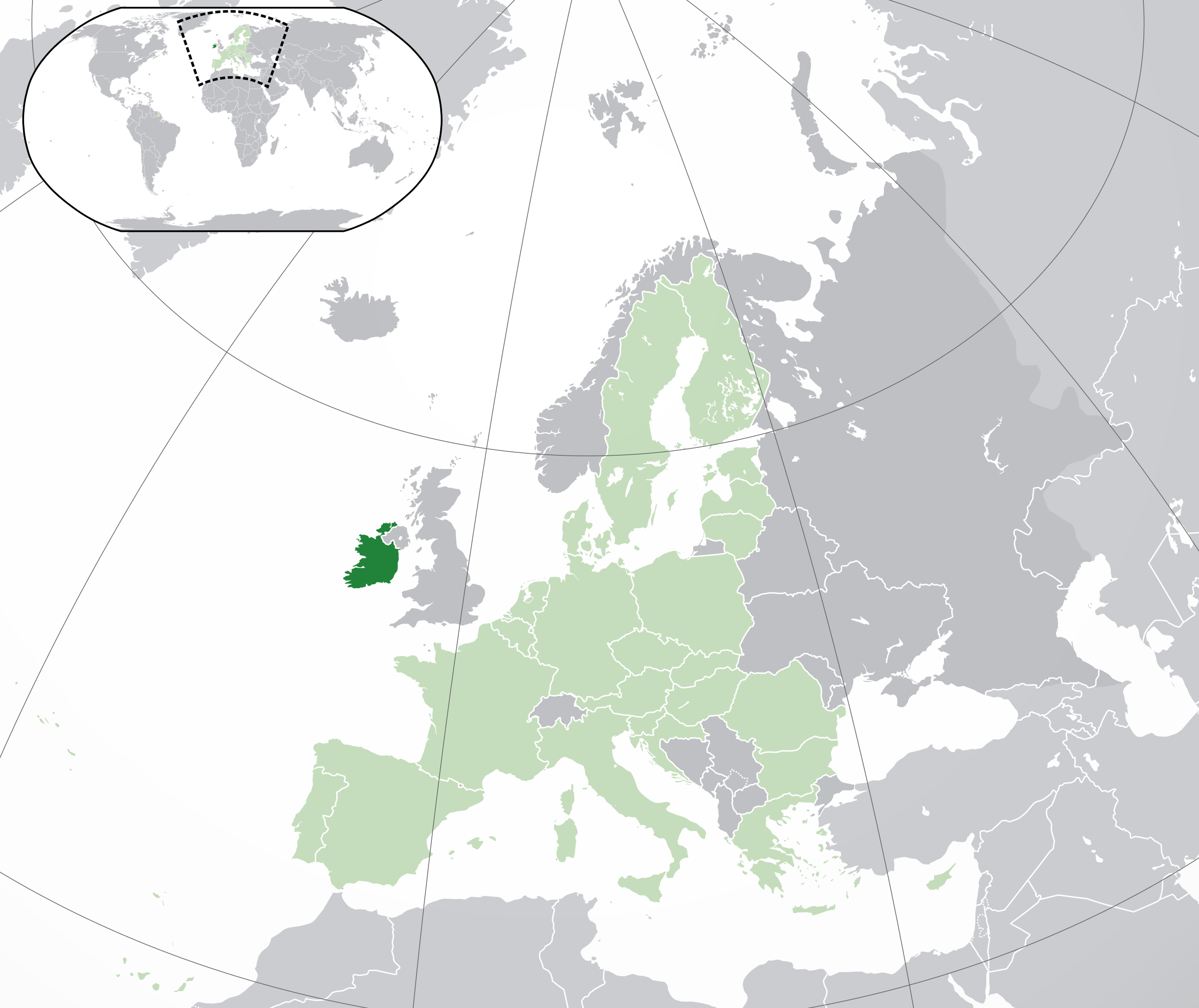
English: (Dark-Green) Republic of Ireland. (Light-Green) The rest of the European Union (EU). (Dark-gray) The rest of Europe. (Light-gray) The surrounding region.
See also: |
| SVG genesis | |
| Petsa | |
| Gigikanan | |
| Tagsulat | NuclearVacuum |
| Other versions |
|


_in_Europe.png)
Pagtugot
I, the copyright holder of this work, hereby publish it under the following licenses:
This file is licensed under the Creative Commons Attribution-Share Alike 3.0 Unported license.
- Libre ka:
- sa pagsabwag – sa pagkopya, pag-apod-apod ug pagsabwag sa hinimo
- sa pag-remix – sa pag-adap sa binuhat
- Ubos sa mosunod nga mga kondisyon:
- atribusyon – Kinahanglan nimo nga hatagan ang angay nga kredito, maghatag usa ka link sa lisensya, ug ipakita kung adunay mga pagbag-o. Mahimo nimo kini buhaton sa bisan unsang makatarunganon nga paagi, apan dili sa bisan unsang paagi nga nagsugyot nga gi-endorso ka sa licensor o ang imong paggamit.
- share parehas – Kung imong gi-remix, gibag-o, o gibase sa materyal, kinahanglan nimo nga iapod-apod ang imong mga kontribusyon sa ilawom sa parehas o katugma nga lisensya sama sa orihinal.

|
Gitugot ang pagkopya, pag-apud-apod o/ug pag-usab ning maong dokumento ubos sa mga termino sa GNU Free Documentation License, Version 1.2 o mas bag-ong bersiyon nga gimantala sa Free Software Foundation; nga walay Invariant Sections, walay Front-Cover Texts, ug walay Back-Cover Texts. Ang kopya sa lisensiya gilakip sa bahin nga giulohang GNU Free Documentation License. |
You may select the license of your choice.
| Annotations | This image is annotated: View the annotations at Commons |
Kaagi sa payl
I-klik ang petsa/oras aron makit-an ang hulagway sa payl niadtong panahona.
| Petsa/Takna | Thumbnail | Mga dimensyon | Tiggamit | Komento | |
|---|---|---|---|---|---|
| kasamtangan | 05:03, 1 Pebrero 2020 | | 2,045 × 1,720 (7.33 MB) | Rob984 | UK and Gibraltar have left the EU. New base which includes all of Portugal's islands within frame, as well as Arctic Russian islands part of Europe. Also fixed Flevoland in the Netherlands. |
| 20:31, 25 Oktubre 2016 |  | 2,045 × 1,720 (7.32 MB) | Giorgi Balakhadze | Rv of sockpuppet and per COM:OVERWRITE | |
| 15:59, 18 Marso 2015 |  | 2,045 × 1,720 (7.38 MB) | Mapclean | Reverted to Leftcry's version, please go to your talk page | |
| 14:07, 21 Pebrero 2015 |  | 2,045 × 1,720 (2.62 MB) | VS6507 | Spain. Greece. Slovakia. Cyprus. Romania VETO | |
| 19:37, 16 Nobiyembre 2014 |  | 2,045 × 1,720 (7.38 MB) | Leftcry | Reverted to version as of 15:40, 6 August 2014 Please go to your talk page | |
| 16:34, 16 Nobiyembre 2014 |  | 2,045 × 1,720 (2.62 MB) | A2D2 | The map must show the original de-jure status with no breakaway regions, as it was originally created. An alternative map showing the de-facto status with breakaway regions needs to be created instead. | |
| 15:48, 16 Nobiyembre 2014 |  | 2,045 × 1,720 (7.38 MB) | A2D2 | Reverted to version as of 10:27, 13 July 2014 | |
| 15:40, 6 Agosto 2014 |  | 2,045 × 1,720 (7.38 MB) | Rob984 | Sudan | |
| 10:27, 13 Hulyo 2014 |  | 2,045 × 1,720 (7.38 MB) | Rob984 | More accurate coastline, borders, etc. Slightly different centre point. Added gradient and longitude and latitude lines. Otherwise it's difficult to tell what kind of projection this is and therefore potentially misleading. | |
| 09:14, 1 Hulyo 2013 |  | 2,045 × 1,720 (2.62 MB) | U5K0 | croatia |
Mga paggamit sa payl
Ang mosunod nga mga panid misumpay niining payl:
Global nga paggamit sa payl
Kining ubang wiki naggamit ning maong payl:
- Paggamit sa ady.wikipedia.org
- Paggamit sa af.wikipedia.org
- Paggamit sa ami.wikipedia.org
- Paggamit sa ar.wikipedia.org
- جمهورية أيرلندا
- مستخدم:ElWaliElAlaoui/ملعب 8
- معاملة المثليين في جمهورية أيرلندا
- العلاقات الأنغولية الأيرلندية
- العلاقات الأيرلندية الكورية الجنوبية
- العلاقات الإريترية الأيرلندية
- العلاقات الأيرلندية السويسرية
- العلاقات الألمانية الأيرلندية
- العلاقات الأيرلندية الليختنشتانية
- العلاقات البوليفية الأيرلندية
- العلاقات الأيرلندية الموزمبيقية
- العلاقات الألبانية الأيرلندية
- العلاقات البلجيكية الأيرلندية
- العلاقات الإثيوبية الأيرلندية
- العلاقات الأيرلندية البيلاروسية
- العلاقات الأيرلندية الطاجيكستانية
- العلاقات الأيرلندية الروسية
- العلاقات الأيرلندية الرومانية
- العلاقات الأرجنتينية الأيرلندية
- العلاقات الأيرلندية الغامبية
- العلاقات الأيرلندية القبرصية
- العلاقات الأيرلندية السيراليونية
- العلاقات الأيرلندية النيبالية
- العلاقات الأيرلندية الليبيرية
- العلاقات التشيكية الأيرلندية
- العلاقات الأيرلندية الميانمارية
- العلاقات السعودية الأيرلندية
- العلاقات الأيرلندية الكندية
- العلاقات الأيرلندية الزيمبابوية
- العلاقات الإسرائيلية الأيرلندية
- العلاقات البالاوية الأيرلندية
- العلاقات الأيرلندية المالية
- العلاقات الأيرلندية النيجيرية
- العلاقات اليمنية الأيرلندية
- العلاقات الأيرلندية الفانواتية
- العلاقات الغابونية الأيرلندية
- العلاقات البنمية الأيرلندية
- العلاقات الأيرلندية الكوبية
- العلاقات الأيرلندية الجورجية
- العلاقات التونسية الأيرلندية
- العلاقات الأيرلندية الكورية الشمالية
- العلاقات الهندية الأيرلندية
- العلاقات الإيطالية الأيرلندية
- العلاقات الأيرلندية الناوروية
- العلاقات الأسترالية الأيرلندية
- العلاقات الأيرلندية الزامبية
View more global usage of this file.