Jump to content

Payl:Enloe Dam.jpg

Page contents not supported in other languages.
Gikan sa Wikipedia, ang gawasnong ensiklopedya

Tibuok resolusyon(4,719 × 3,680 pixels, size sa payl: 1.82 MB, MIME type: image/jpeg)

Kining maong payl gikan sa Wikimedia Commons ug mahimong gigamit sa ubang proyekto. Ang deskripsyon niini didto gipakita sa ubos.

Mubong sugid:

Deskripsyon

This is an image of a place or building that is listed on the National Register of Historic Places in the United States of America. Its reference number is 78002764.

Petsa
Gigikanan

Historic American Engineering Record; Library of Congress HAER WASH,24-ORO.V,1-5

This image is available from the United States Library of Congress's Prints and Photographs division
under the digital ID hhh.wa0183.
This tag does not indicate the copyright status of the attached work. A normal copyright tag is still required. See Commons:Licensing.

العربية  беларуская (тарашкевіца)  বাংলা  čeština  Deutsch  English  español  فارسی  suomi  français  galego  עברית  magyar  Bahasa Indonesia  italiano  日本語  lietuvių  македонски  മലയാളം  Nederlands  polski  português  português do Brasil  română  русский  sicilianu  slovenčina  slovenščina  Türkçe  українська  简体中文  繁體中文  +/−

Tagsulat Harvey S. Rice
Other versions
image extraction process
This file has been extracted from another file
: VIEW SHOWING SPILLWAY AND DIVERSION CHANNEL OF RAZED POWERHOUSE, LOOKING NORTHWEST - Enloe Dam, On Similkameen River, Oroville, Okanogan County, WA HAER WASH,24-ORO.V,1-5.tif
original file
Object location48° 57′ 57″ N, 119° 30′ 03″ W Kartographer map based on OpenStreetMap.View this and other nearby images on: OpenStreetMapinfo

Pagtugot

Public domain This image or media file contains material based on a work of a National Park Service employee, created as part of that person's official duties. As a work of the U.S. federal government, such work is in the public domain in the United States. See the NPS website and NPS copyright policy for more information.

Captions

Add a one-line explanation of what this file represents

Items portrayed in this file

depicts English

48°57'56.999"N, 119°30'2.999"W

Kaagi sa payl

I-klik ang petsa/oras aron makit-an ang hulagway sa payl niadtong panahona.
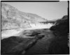
Petsa/TaknaThumbnailMga dimensyonTiggamitKomento
kasamtangan02:27, 28 Marso 2009Thumbnail sa bersyon sa 02:27, 28 Marso 20094,719 × 3,680 (1.82 MB)Martin H.High res; cropped
01:02, 25 Septiyembre 2008Thumbnail sa bersyon sa 01:02, 25 Septiyembre 2008640 × 508 (38 KB)Murderbike~commonswiki{{Information |Description={{en|1=The Enloe Dam near Oroville, Washington.}} |Source=http://memory.loc.gov/cgi-bin/displayPhoto.pl?path=/pnp/habshaer/wa/wa0100/wa0183/photos&topImages=168475pr.jpg&topLinks=168475pv.jpg,168475pu.tif&title=5.%20%20VIEW%20SH

Ang mosunod nga mga panid misumpay niining payl:

Global nga paggamit sa payl

Kining ubang wiki naggamit ning maong payl:

Metadata