
Payl:Fife Ness Lighthouse - geograph.org.uk - 937536.jpg
Walay mas taas nga resolusyon.
Fife_Ness_Lighthouse_-_geograph.org.uk_-_937536.jpg (640 × 427 pixels, size sa payl: 248 KB, MIME type: image/jpeg)
Mubong sugid:
| Deskripsyon |
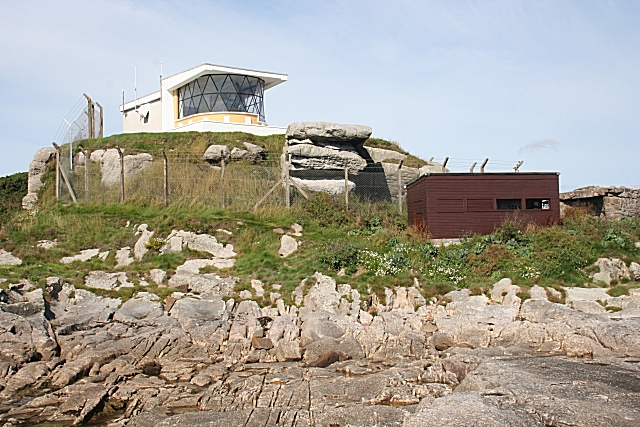
English: Fife Ness Lighthouse. Located at the easternmost point of Fife, marking the north side of the entrance to the Firth of Forth. An example of a low-rise lighthouse. The dark hut below and to the right is a birdwatching hide. Large numbers of birds pass close by just offshore on migration every spring and autumn. |
| Petsa | |
| Gigikanan | From this image at geograph.org.uk; transferred by User:JotaCartas using geograph_org2commons. |
| Tagsulat | Anne Burgess |
| Pagtugot (Paggamit pag-usab niini nga file) |
Creative Commons Attribution Share-alike license 2.0 |
| Attribution (required by the license) | Anne Burgess / Fife Ness Lighthouse / |
| Camera location | | View this and other nearby images on: OpenStreetMap |
|---|
| Object location | | View this and other nearby images on: OpenStreetMap |
|---|
_region:GB-GBN_heading:337.00&language=ceb)
Pagtugot

|
This image was taken from the Geograph project collection. See this photograph's page on the Geograph website for the photographer's contact details. The copyright on this image is owned by Anne Burgess and is licensed for reuse under the Creative Commons Attribution-ShareAlike 2.0 license.
|
This file is licensed under the Creative Commons Attribution-Share Alike 2.0 Generic license.
Attribution: Anne Burgess
- Libre ka:
- sa pagsabwag – sa pagkopya, pag-apod-apod ug pagsabwag sa hinimo
- sa pag-remix – sa pag-adap sa binuhat
- Ubos sa mosunod nga mga kondisyon:
- atribusyon – Kinahanglan nimo nga hatagan ang angay nga kredito, maghatag usa ka link sa lisensya, ug ipakita kung adunay mga pagbag-o. Mahimo nimo kini buhaton sa bisan unsang makatarunganon nga paagi, apan dili sa bisan unsang paagi nga nagsugyot nga gi-endorso ka sa licensor o ang imong paggamit.
- share parehas – Kung imong gi-remix, gibag-o, o gibase sa materyal, kinahanglan nimo nga iapod-apod ang imong mga kontribusyon sa ilawom sa parehas o katugma nga lisensya sama sa orihinal.
Kaagi sa payl
I-klik ang petsa/oras aron makit-an ang hulagway sa payl niadtong panahona.
| Petsa/Takna | Thumbnail | Mga dimensyon | Tiggamit | Komento | |
|---|---|---|---|---|---|
| kasamtangan | 19:29, 4 Marso 2010 | | 640 × 427 (248 KB) | File Upload Bot (Magnus Manske) | == {{int:filedesc}} == {{Information |Description={{en|1=Fife Ness Lighthouse}} |Source=From [http://www.geograph.org.uk/photo/937536 this image] at [http://geograph.org.uk geograph.org.uk]; transferred by User:JotaCartas using [http://toolserver.org/ |
Mga paggamit sa payl
Ang mosunod nga mga panid misumpay niining payl:
Global nga paggamit sa payl
Kining ubang wiki naggamit ning maong payl:
- Paggamit sa cs.wikipedia.org
- Paggamit sa de.wikipedia.org
- Paggamit sa en.wikipedia.org
- Paggamit sa fr.wikipedia.org
- Paggamit sa ga.wikipedia.org
- Paggamit sa www.wikidata.org