
Payl:Forest fire mae hong son province 01.jpg

Gidak-on ning maong paunang tan-aw: 800 x 455 ka mga piksel. Uban pang mga resoluyon: 320 x 182 ka mga piksel | 640 x 364 ka mga piksel | 1,024 x 582 ka mga piksel | 1,280 x 727 ka mga piksel | 1,920 x 1,091 ka mga piksel.
Tibuok resolusyon (1,920 × 1,091 pixels, size sa payl: 774 KB, MIME type: image/jpeg)
Mubong sugid:
| Deskripsyon |
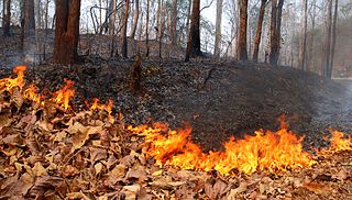
English: A forest fire along road 108 between Mae Sariang and Khun Yuam, in Mae Hong Son province. It was one of the many fires that day. This is done mainly so that the Astraeus asiaticus (English: false earthstar; Thai script: เห็ดเผาะ; Thai het pho) fungus (which fetches a high price on the Thai market) are easier to find. The fires completely denude the undergrowth and affects the wildlife but most of the trees are not really affected. |
| Petsa | |
| Gigikanan | Kaugalingong trabaho |
| Tagsulat | Takeaway |
| Camera location | | View this and other nearby images on: OpenStreetMap |
|---|
Pagtugot
I, the copyright holder of this work, hereby publish it under the following licenses:
This file is licensed under the Creative Commons Attribution-Share Alike 3.0 Unported license.
- Libre ka:
- sa pagsabwag – sa pagkopya, pag-apod-apod ug pagsabwag sa hinimo
- sa pag-remix – sa pag-adap sa binuhat
- Ubos sa mosunod nga mga kondisyon:
- atribusyon – Kinahanglan nimo nga hatagan ang angay nga kredito, maghatag usa ka link sa lisensya, ug ipakita kung adunay mga pagbag-o. Mahimo nimo kini buhaton sa bisan unsang makatarunganon nga paagi, apan dili sa bisan unsang paagi nga nagsugyot nga gi-endorso ka sa licensor o ang imong paggamit.
- share parehas – Kung imong gi-remix, gibag-o, o gibase sa materyal, kinahanglan nimo nga iapod-apod ang imong mga kontribusyon sa ilawom sa parehas o katugma nga lisensya sama sa orihinal.

|
Gitugot ang pagkopya, pag-apud-apod o/ug pag-usab ning maong dokumento ubos sa mga termino sa GNU Free Documentation License, Version 1.2 o mas bag-ong bersiyon nga gimantala sa Free Software Foundation; nga walay Invariant Sections, walay Front-Cover Texts, ug walay Back-Cover Texts. Ang kopya sa lisensiya gilakip sa bahin nga giulohang GNU Free Documentation License. |
You may select the license of your choice.
Kaagi sa payl
I-klik ang petsa/oras aron makit-an ang hulagway sa payl niadtong panahona.
| Petsa/Takna | Thumbnail | Mga dimensyon | Tiggamit | Komento | |
|---|---|---|---|---|---|
| kasamtangan | 08:25, 24 Marso 2010 | | 1,920 × 1,091 (774 KB) | Takeaway | {{Information |Description={{en|1=A forest fire along the road from Mae Sariang to Khun Yuam, Mae Hong Son province. It was one of the many fires that day.}} |Source={{own}} |Author=Takeaway |Date=2010-03-14 |Permission= |other_versions= |
Mga paggamit sa payl
Ang mosunod nga mga panid misumpay niining payl:
Global nga paggamit sa payl
Kining ubang wiki naggamit ning maong payl:
- Paggamit sa ar.wikipedia.org
- Paggamit sa de.wikipedia.org
- Paggamit sa en.wikipedia.org
- Paggamit sa hi.wikipedia.org
- Paggamit sa ml.wikipedia.org
- Paggamit sa nl.wikipedia.org
- Paggamit sa sv.wikipedia.org
- Paggamit sa szl.wikipedia.org
- Paggamit sa th.wikipedia.org
- Paggamit sa vi.wikipedia.org
- Paggamit sa www.wikidata.org